Goldenplug
Hero Member
- Jul 30, 2014
- 777
- 1,078
- Detector(s) used
- Garrett ace 250 8.5 x 11 dd coil, teknetics t2, sniper coil, dd coild, lesche digger, gator tool, garrett propointer.
- Primary Interest:
- All Treasure Hunting
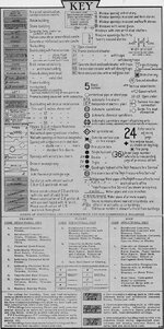
 Hello everybody. My question for the informed privy digger is: How do you read the outhouse locations on a map like this? It’s an 1876 insurance map. The key indicates the [X] is an outhouse. Is that telling me the general location is (for example) in the back? According to this all the properties have a very long “outhouse” in the back which can’t possibly be right. It is like that street after street. Anybody ever run into this? Is it maybe that it’s not indicating a privy but a stable? I would assume most if not all residences should have a privy in 1876. Correct? Thanks
Amazon Forum Fav 👍


Last edited: