The Pearl Ship

Isayhello2u

Full Member
Sep 15, 2006
110
27
california
Primary Interest:
Other
i haven't been here for a while but will toss my two cents in again.

what changed the pattern of the how the lower Colorado river flooded and flowed was the arrival of the Americans.

if left alone the Colorado with its tidal bore would have shifted both its main channel and the location of its mouth with frequency and over wide distances miles apart. hence some of the early mapping confusion
a Spanish explorer renaming the river because its mouth was miles/leagues from where a previous explorer
charted it. The British Lt. Hardy esp had trouble finding the Colorado's mouth.
this shifting is a natural phenomenon that occurs in most rivers with large tidal bores.

some of the steamships were able to go as far as Callville when the water was high.
http://www.quehoposse.org/steamboatplaque.html


things Americans did in the early days to keep the Colorado in what has become the main channel

in one of the travel journals describing a steamship trip up the colorado from the mouth.
the writer describes how when encountering a sandbar the boat reversed and used its paddles to dig
the channel deeper.

when the spring floods did bring down silt and snags that damned the river and started flooding the
palo verde vally california in the early 1900s. these natural dams were set with dynomite
and exploded by the local homesteaders (I once knew someone who had this as his first paid job)

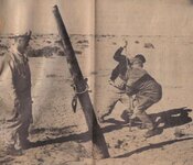
the thing that really killed the river and made it stay as we know it today of course is the dams
starting with the building of the Yuma dam which cut travel up river and down off.

cyas laters guys
 

Isayhello2u

Full Member
Sep 15, 2006
110
27
california
Primary Interest:
Other
just wondering about the outlet from the ancient lake. I've been told it goes by split mountain to laguna salada and that the watermarks of the outflow are still visible. anyone have any photos of this?
am unable to go look for myself.
 

pegleglooker

Bronze Member
Jun 9, 2006
1,857
237
Banning, California
Detector(s) used
ace 250
Primary Interest:
All Treasure Hunting
Hey all,
As far as the old coastline is concerned I have seen a lot of it out by Travertine Point. It basically borders that Torres Martinez res on the W side. I was just out there on Mon ( 7/14 ) I'll post some pixs here. As far as Split Mt is concerned I have read about a waterway that once went thru it. Here's a quote from " Anza Borrego Guide Book " by Parker ( 1957 ):
" Legend states that Fish Creek in relatively recent times was a sluggish flowing creek, and it's sandstone and fanglomerate ( ? ) floor was pitted with huge potholes, full of water, many of them containing fish. The floods of 1916, according to the old timers, laid a carpet of sand and rock which effectually filled in the potholes, leaving the wash as it is seen today. "
This also goes along with a story of a desert rat named Butcherknife Ike That said he found the remnants of a ship while camping overnight in the area. I haven't been that way yet, but I WILL be there this winter for sure.
I do have a interest in the Split Mt connection, however I just don't know how deep the waterway could have been. If the flood of 1916 dropped sand onto the desert floor, then just how low was the floor before ??

PLL

Picture 013.jpg

Picture 015.jpg

Picture 016.jpg
 

Isayhello2u

Full Member
Sep 15, 2006
110
27
california
Primary Interest:
Other
Nice pictures. the other problem of finding how deep the outlet was is that area is being slowly uplifted
but the idea is that the entire colorado terminated in the ancient lake. the egress from the lake being the outflow (the amarillo, yellow western river) by split mountain (a rocky channel) into laguna salada when the laguna salada is filled it would be easy to enter from the ocean (may even have been part of the ocean at the time in question). This being described as a shorter / better route to get a ship into the ancient lake than up the colorado river.
 

pegleglooker

Bronze Member
Jun 9, 2006
1,857
237
Banning, California
Detector(s) used
ace 250
Primary Interest:
All Treasure Hunting
Hello Isayhello2u,
Your waterway is a very interesting route, one I have thought of before. There is even a pix of a guy in the 60's who found a boat out in the northern end of Salada.

lostship3.jpg

I just got a book called North to California by Paul A Meyers, it's the 1st volume of a 2 volume set. Basically talking about ALL explorers to California via land or water. He talks about how Alacron sailed up the Colorado past Yuma in 1540. During this route they had a helluva time getting thru. There was no dicussion about a alternate route up thru the Salada, which most likely means it was dry or not deep enough for ships ( even the ones with shallow bottoms ). I do find it interesting that the quote above is from a 1957 Anza Borrego book and quotes how potholes with fish in it were seen by the oldtimers. The is the same quote by Anza himself in 1774/5/6 I can't remember which one, it might be above somewhere. Maybe there was a waterway thru Split Mt and down the Carrizo Corridor... It's possible. Do you have anything more on this idea ??

PLL
 

Attachments

  • lostship3.jpg
    lostship3.jpg
    44.6 KB · Views: 1,822

crawdad

Newbie
May 21, 2009
3
0
Mission Texas
Detector(s) used
home made
Bob MCkne on old cattleman said thair was a old ship in the mud Hills SE.ov fishcreek mts with just the Ribs showing around 1938
 

Oroblanco

Gold Member
Jan 21, 2005
7,838
9,830
DAKOTA TERRITORY
Detector(s) used
Tesoro Lobo Supertraq, (95%) Garrett Scorpion (5%)
WELCOME TO TREASURENET CRAWDAD! :icon_thumright: Thanks for the info too! Please post more? Thank you in advance,
Oroblanco
:coffee2:
 

ghostdog

Sr. Member
Apr 22, 2007
286
15
Re: The Pearl Ship /Yuma desert

Barry Storm for sure, and Karl von Mueller I think, both refer to incidents in their books of private planes flying over the Yuma desert,and the pilots spotting the masts of ships or ships themselves in the desert. In one case a pilot went back by jeep,but could not locate the ship. I drive to Vegas often, and in a desolite spot in desert dunes, before Yerma, going North off the Hiway I keep spotting what look likes ships ribs sticking out of the sand. Probably modern,although the surrpunding area looks like it could have been a harbor at one time.
 

Isayhello2u

Full Member
Sep 15, 2006
110
27
california
Primary Interest:
Other
just a heyas .. welcome to crawdad.

on the question i was asked a year ago but didn't answer about the alternate route

if you can get a small paddlewheel steam ship up the colorado to callville then you could get a caravel of about the same size someplace up the western river on the tidal bore if it existed.

btw does anyone know anything about an early map of the region that shows the Gila reaching the gulf
without merging with the Colorado first ?
 

surrealpillow

Tenderfoot
Jun 6, 2009
5
6
I've researched a good bit on this subject and it's my belief that there is
more than one ship in this area due to the variations in the accounts describing the
locations.
I am very interested in the viking ship, as the earth was warmer and sea levels were higher in the 11Th and 12Th centuries it seems reasonable that a good part of this area was under water at that time since it is below sea level even today and little is known about the actual extent of viking travel into the Americas.
Secondly, the idea of there being a Chinese junk, as new evidence is coming out every year supporting china's travel to America.(there are some very compelling and interesting books/websites on these subjects if anyone is interested.)
Lastly the caravel seems the most plausible. I don't believe that it necessarily has to be Spanish or that of Juan De Iturbe. (I've been trying to get ahold of first hand or government documentation of De Iturbe actually loosing a ship.)
Supposing a ship sent from wherever ended up in lake Cahuilla and none of the crewmen returned to tell about it, there would be no documentation other than that of a missing ship, of which there are many. If the ship was a private or pirating vessel there likely would be no documentation at all.
So anyway that's just a summary of my views. Of course there are certain spots I think a ship might be hiding for certain reasons & my motivation is not to find pearls or treasure but a piece of history.
As per the last post, i have seen a lot of old maps of this region but don't recall specifically seeing one that showed the Gila emptying directly into the gulf.
If anyone is interested in sharing information or even an expedition let me know. I regret jumping in on this topic so late, as I'm new to this forum.
cheers!
 

pegleglooker

Bronze Member
Jun 9, 2006
1,857
237
Banning, California
Detector(s) used
ace 250
Primary Interest:
All Treasure Hunting
hey gang,
Well some will tell you, that this and the pegleg smith story are my two MOST favorite. I have dug loooong and deep on this. Surrealpillow, I have been in contact with a researcher in Madrid ( the Spanish archives ), to check on the same thing. But frankly right now I do NOT have $2K to invest in this ( times being they way they are ). But if you find anything PLEASE send me a PM.... I would like to hear what you found - if you are willing to share -. Sayhello there are many, many old maps, but I don't remember one that showed the Gila as a river going into the gulf. However, the Colorado may have been " mislabeled " as the Gila, and maybe that's what you are referring to ??? Here's a map from 1702, that shows the Gila flowing into the Colorado ( I know it's no help - sorry - ). The oldest map I know of is 1587 and there is also a Dutch map from 1602, but both show the Colorado. In fact the dutch one doesn't even show the Gila at all.... But if you find something....... I'm all ears..

PLL
 

Oroblanco

Gold Member
Jan 21, 2005
7,838
9,830
DAKOTA TERRITORY
Detector(s) used
Tesoro Lobo Supertraq, (95%) Garrett Scorpion (5%)
WELCOME TO TREASURENET Surrealpillow! :thumbsup:


Please do continue! I too think it a good possibility that there could be more than one lost ship in the desert. I have been trying to locate photos of the "Viking ship" which was supposedly photographed. Juan de Iturbe made it back to "civilization" or we would not even know the story of the Pearl ship, and there was an investigation according to at least one source. So you may be able to locate original documents in this case. With the other ships it is another question. If a Viking ship did end up trapped in Lake Coahuilla, there is little chance of any written record, though the Mayo Indians of Mexico have a legend that might "fit" with Vikings, and Mayos were known for often having blond hair and blue eyes. The English pirate or privateer ship Content is another candidate, but "officially" it is just another lost ship. The UK has good records of ships, but when one just disappeared we don't have any record. I look forward to reading more, and our amigo Pegleglooker has a great deal of info I hope he won't mind sharing! ;D
Oroblanco
 

pegleglooker

Bronze Member
Jun 9, 2006
1,857
237
Banning, California
Detector(s) used
ace 250
Primary Interest:
All Treasure Hunting
hey gang,
SENOR ORO!!!!!! Ola Amigo..... How goes it ??? I hope the cattle ( or horses I don't remember ) are in their corrals and snug like bug.....I'm VERY glad to see you are still being as active as you can be, with work and all. And I humbly thank you for the " kudos " about the pearl ship. It's true I have been researching this for YEARS and have gained a sizable library of sorts. If anyone has any questions ( that I can answer ) I am all ears and will gladly share what I have...As for the viking ship, the photo was shown to Myrtle Botts by a traveling prospector. Botts was in the Terra Blanca Mts off the S2 near the Canebrake canyon, Botts was the head librarian in Julian and a avid flower lover. After sharing a meal with the prospector, he told here where the ship was located and she did find it !!! But as she was leaving, a earthquake struck and the side of the hill fell taking the ship with it to the bottom of the canyon...

terra blanca mts.jpg

I am of belief that Iturbe NEEDS to be researched in the archive to either say he is... or is not one of the top candidates... The other is the captain of the Content Thoams Cavendish and there are several smaller " pirates that worked up and down the Baja and Californian coast....

enjoy
PLL
 

bobinsd

Sr. Member
Oct 20, 2005
491
250
San Diego California
Detector(s) used
Bounty Hunter
Primary Interest:
All Treasure Hunting
I received a recent photo of a petroglyph from the Pinto Canyon area just north of the Mex. border from a hiker. The obvious striking image of a single sail/mast (square rig) can be seen among the stick figures. This area is many miles from the coast and just north of La Rumorosa, which overlooks Laguna Salada, and is in the vicinity of the sighting of the Vikiing Dragon ship supposedly found in the mountains of this region.
Anyone interested in mor details, just ask here.
 

Attachments

  • petroglyphs.jpg
    petroglyphs.jpg
    23.3 KB · Views: 1,779

pegleglooker

Bronze Member
Jun 9, 2006
1,857
237
Banning, California
Detector(s) used
ace 250
Primary Interest:
All Treasure Hunting
hey gang,
Hey Bob, do you know if the rock art has been dated by anyone ?? I also think that the Laguna Salada area " may " be one of the the hotspots for a lost ship.... Or at least the Viking Saga, getting back to the rock, what elevation was it found at and what direction was it facing ( N S E or W ). And lastly was found on the northern end, maybe near Davies Canyon ? Looking forward to your answer.....

Thx
PLL
 

Oroblanco

Gold Member
Jan 21, 2005
7,838
9,830
DAKOTA TERRITORY
Detector(s) used
Tesoro Lobo Supertraq, (95%) Garrett Scorpion (5%)
HOLA mi amigo Pegleglooker! Thank you for asking - been busy as h-ll and often don't get home so can't get online much. Fortunately now that the cattle are in the summer pasture (branding etc is done) I hope to get home more often. I hope you are doing well and look forward to more of your posts. :read2: :thumbsup:
your amigo in 'Dakota Territory'
Roy ~ Oroblanco
:coffee:
 

bobinsd

Sr. Member
Oct 20, 2005
491
250
San Diego California
Detector(s) used
Bounty Hunter
Primary Interest:
All Treasure Hunting
I picked up the recent issue today and read the article, which had no pics. The author, a respected wedding photog, sent me all the pics from the trip. It is obviously legit. South of the border near La Rumorosa, there are many similar markings in the mountains. Google la rumorosa). The article is at http://www.sandiegoreader.com/news/2009/jun/03/cover/

And the website pics are at http://robertmarcos.com/pinto-canyon. I have asked the author if he had the GPS coordinates of the site but have not received a reply. I ask all Tnetters NOT to contact him because I have not explained to him the possible significance of the artwork, and he is (according to his article) upset at fing a picture of a boat rather than a saber tooth cat.

I will keep you informed if I get a response to the GPS request. In the meantime, please respect his privacy...he knows nothing of Tnet.

Bob
 

Top Member Reactions

Users who are viewing this thread

Latest Discussions

Top