mrs.oroblanco
Silver Member
- Jan 2, 2008
- 4,356
- 427
- Detector(s) used
- Tesoro Lobo & Garrett Stinger
- Primary Interest:
- All Treasure Hunting
Re: The "Peralta" Stone Maps --- On Their Own
Joe,
Thanks, but, Starman talked about it before that.
Starman wrote:
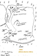
And, I'd simply like to know how he knew we were in Fish Creek Canyon.
Beth
BTW: post #136
Joe,
Thanks, but, Starman talked about it before that.
Starman wrote:
Roy,
It is good to see you made it back from Fish Creek Canyon. I have been told some very strange folks live in the area
And, I'd simply like to know how he knew we were in Fish Creek Canyon.
Beth
BTW: post #136