The Peralta Stone Maps, Real Maps to Lost Gold Mines or Cruel Hoax?

Do you think the Peralta stone maps are genuine, or fake?


  • Total voters
    121

mrs.oroblanco

Silver Member
Jan 2, 2008
4,356
427
Black Hills of South Dakota
Detector(s) used
Tesoro Lobo & Garrett Stinger
Primary Interest:
All Treasure Hunting

gollum

Gold Member
Jan 2, 2006
6,729
7,596
Arizona Vagrant
Detector(s) used
Minelab SD2200D (Modded)/ Whites GMT 24k / Fisher FX-3 / Fisher Gold Bug II / Fisher Gemini / Schiebel MIMID / Falcon MD-20
Primary Interest:
All Treasure Hunting
Oroblanco said:
Most likely the Superstitions, yet what about those two water courses? They may be rivers or creeks, but there are no such matching parallel waterways in the Superstitions. Finding a map in Arizpe does not mean that map must apply to Arizpe either; it could be a map of Guatemala's highlands unless it is marked with place names that clearly identify where it applies. There are other areas that will "fit" those stone maps, regardless of those who claim they will only fit the Superstitions, and which include those two water courses along the sides of the maps, even within Arizona. There is no "pinnacle" marked on them, no Four Peaks either, which one would expect for a map of the Superstitions after all. Besides, the stone maps were not found IN the Superstitions for that matter.
Roy

PS I will be absent more often in the coming weeks, nothing wrong just very bizzie; so I will fall behind in the discussions. I will try to catch up when possible but will not be able to keep up.

Remember Roy,

MOST LIKELY! I guess you forgot that part. The stones were found within five miles of the Supers (until somebody shows me something other than an active imagination I will go with what Travis Tumlinson said).

YES Roy. The maps COULD POSSIBLY refer to the Guatemala Highlands. Is that more likely than a place within five miles of where they were found? NO.

MOST LIKELY! PERIOD!

If YOU found the stones under the floor of the Arizpe Mission, and there were no markings that POSITIVELY identified the area they referred to, where would you start looking? Guatemala? Unless you are somehow related to BB, I highly doubt it. HAHAHA You would start your investigation using Arizpe Mission at the center of the search. WHY? Because with a lack of evidence to the contrary, the MOST LIKELY place is the area in which they were found.

Best-Mike
 

OP
OP
Oroblanco

Oroblanco

Gold Member
Jan 21, 2005
7,838
9,830
DAKOTA TERRITORY
Detector(s) used
Tesoro Lobo Supertraq, (95%) Garrett Scorpion (5%)
gollum said:
Roy,

I don't assume anything. I read the story:

".........they bought two burros and pack saddles, bedding, grub, etc. To the tune of eighty-four dollars; packed up and started back for their mine."

That was the last anybody saw of them (except for whomever killed them). There are three possibilities:

1. Indians: their bodies were found stripped just like as if they had been killed by Apache. If Indians HAD killed them, that would explain why the saddlebags were left behind.

2. The Swamper from a saloon at the King disappeared right after the two soldiers left. When he returned, he lied about having been in Florence. Soon after some tough questioning, he disappeared forever (Well, almost forever).

3. In the Holmes Manuscript, Waltz told Dick Holmes that he had murdered the two soldiers and made it look like an Indian depredation.

Best-Mike

Didn't the swamper TAKE the gold from the two soldiers? There should not be any saddlebags of gold to find. Indians have been known to dump out the contents of saddlebags (and even flour sacks) in order to make use of the bags. Also, the two soldiers were killed on their way returning TO the mine, not coming back from it, they had left their gold in town because they had exchanged it for MONEY remember? If it were saddlebags of COINS now we would have a different deal.

Gollum also wrote
Remember Roy,

MOST LIKELY! I guess you forgot that part. The stones were found within five miles of the Supers (until somebody shows me something other than an active imagination I will go with what Travis Tumlinson said).

YES Roy. The maps COULD POSSIBLY refer to the Guatemala Highlands. Is that more likely than a place within five miles of where they were found? NO.

MOST LIKELY! PERIOD!

If YOU found the stones under the floor of the Arizpe Mission, and there were no markings that POSITIVELY identified the area they referred to, where would you start looking? Guatemala? Unless you are somehow related to BB, I highly doubt it. HAHAHA You would start your investigation using Arizpe Mission at the center of the search. WHY? Because with a lack of evidence to the contrary, the MOST LIKELY place is the area in which they were found.

Best-Mike

How far do you say southern Arizona is, <Pimeria Alta specifically> from the site where the stone maps were found? If I found stone maps under the floor of a mission in Arizpe or in Norse ruins in Greenland, I would first try to find the correct geography to match the markings on the maps, not make assumptions about them having to fit some place very close to where the maps were found. Too many people make the instant assumption that the stone maps MUST go to the Superstitions, when there is nothing on them that absolutely MUST, undeniably, be the Superstitions. I don't even think the Superstitions are "MOST LIKELY" - the water courses just don't match very well, sorry but that is a personal opinion so I don't expect you will agree.

**I don't know that the stone maps MUST go to Pimeria Alta either, but it is interesting and those two north-flowing rivers seem to work very well, along with the various hills, mountains and landmarks - even the trail which seems to put the "heart" not far from Reyes visita in the Santa Rita mountains. This idea may be heresy to those who are convinced the stone maps are of the Superstitions, but it is just an idea. Not a personal attack. **
Roy
 

gollum

Gold Member
Jan 2, 2006
6,729
7,596
Arizona Vagrant
Detector(s) used
Minelab SD2200D (Modded)/ Whites GMT 24k / Fisher FX-3 / Fisher Gold Bug II / Fisher Gemini / Schiebel MIMID / Falcon MD-20
Primary Interest:
All Treasure Hunting
Oroblanco said:
gollum said:
Roy,

I don't assume anything. I read the story:

".........they bought two burros and pack saddles, bedding, grub, etc. To the tune of eighty-four dollars; packed up and started back for their mine."

That was the last anybody saw of them (except for whomever killed them). There are three possibilities:

1. Indians: their bodies were found stripped just like as if they had been killed by Apache. If Indians HAD killed them, that would explain why the saddlebags were left behind.

2. The Swamper from a saloon at the King disappeared right after the two soldiers left. When he returned, he lied about having been in Florence. Soon after some tough questioning, he disappeared forever (Well, almost forever).

3. In the Holmes Manuscript, Waltz told Dick Holmes that he had murdered the two soldiers and made it look like an Indian depredation.

Best-Mike

Didn't the swamper TAKE the gold from the two soldiers? There should not be any saddlebags of gold to find. Indians have been known to dump out the contents of saddlebags (and even flour sacks) in order to make use of the bags. Also, the two soldiers were killed on their way returning TO the mine, not coming back from it, they had left their gold in town because they had exchanged it for MONEY remember? If it were saddlebags of COINS now we would have a different deal.

Gollum also wrote
Remember Roy,

MOST LIKELY! I guess you forgot that part. The stones were found within five miles of the Supers (until somebody shows me something other than an active imagination I will go with what Travis Tumlinson said).

YES Roy. The maps COULD POSSIBLY refer to the Guatemala Highlands. Is that more likely than a place within five miles of where they were found? NO.

MOST LIKELY! PERIOD!

If YOU found the stones under the floor of the Arizpe Mission, and there were no markings that POSITIVELY identified the area they referred to, where would you start looking? Guatemala? Unless you are somehow related to BB, I highly doubt it. HAHAHA You would start your investigation using Arizpe Mission at the center of the search. WHY? Because with a lack of evidence to the contrary, the MOST LIKELY place is the area in which they were found.

Best-Mike

How far do you say southern Arizona is, <Pimeria Alta specifically> from the site where the stone maps were found? If I found stone maps under the floor of a mission in Arizpe or in Norse ruins in Greenland, I would first try to find the correct geography to match the markings on the maps, not make assumptions about them having to fit some place very close to where the maps were found. Too many people make the instant assumption that the stone maps MUST go to the Superstitions, when there is nothing on them that absolutely MUST, undeniably, be the Superstitions. I don't even think the Superstitions are "MOST LIKELY" - the water courses just don't match very well, sorry but that is a personal opinion so I don't expect you will agree.

**I don't know that the stone maps MUST go to Pimeria Alta either, but it is interesting and those two north-flowing rivers seem to work very well, along with the various hills, mountains and landmarks - even the trail which seems to put the "heart" not far from Reyes visita in the Santa Rita mountains. This idea may be heresy to those who are convinced the stone maps are of the Superstitions, but it is just an idea. Not a personal attack. **
Roy

WRONG

Maybe your crystal ball showed you that they were on the way TO their mine, but the ONLY thing we KNOW is that they left the Silver King going to their mine. Is there some way you can divine whether they were on the way there or on their way back to the Silver King when they were murdered? If you can do that, then you should be able to tell us whether Walter Gassler was on his way into or out of the mountains when he died (no absolute proof that his pack contained ore)? Had Adolph Ruth already found the mine before he was murdered? Remember, he did write Vene Vidi Vici in his notes.

The swamper was a clubfoot. What do you think would happen if he shot one of the men off his burro? That thing would take off like a shot throwing everything on its' back all over the place. Think old clubfoot would have been able to chase down a running burro? I don't. Remember the Skeleton Canyon Story (near the border Skeleton Canyon).

I would first try to find the correct geography to match the markings on the maps, not make assumptions about them having to fit some place very close to where the maps were found.

ARE YOU REALLY SAYING THAT YOU WOULD NOT BEGIN YOUR SEARCH USING THE PLACE YOU FOUND THE STONES AS GROUND ZERO? REALLY? YOU WOULDN'T START THERE? NOW YOU ARE MAKING ABSOLUTELY NO SENSE.

If you (REALLY) think that neither the Gila nor Queen Creek works, then you are one of a VERY FEW people that have ever examined them that thinks so. I honestly think that now you are just arguing for the sake of arguing.

Mike
 

OP
OP
Oroblanco

Oroblanco

Gold Member
Jan 21, 2005
7,838
9,830
DAKOTA TERRITORY
Detector(s) used
Tesoro Lobo Supertraq, (95%) Garrett Scorpion (5%)
Gollum wrote
I honestly think that now you are just arguing for the sake of arguing.

Well you are mistaken, but I am going to bow out anyway; I won't be able to keep up too well with this (or any) discussion in near future anyway and have not made one bit of progress in trying to get you to see this from a different angle. Yes, I am saying that I would NOT immediately assume that a set of stone maps must apply to a nearby point, and that I would see what area would fit them best before trying to use them. I don't believe that you would make instant assumptions either. I think that if you were to look at the courses of those two streams, compared with those on the stone maps, you MIGHT agree that neither the Gila and Salt nor the Gila and Queen creek are such a good fit, but clearly they match better than any other possibility in your view. I think you are wrong on a whole series of points in this but no amount of arguing seems to make any difference, and your approach certainly doesn't change my view.

Good luck and good hunting Mike and everyone, I hope you find the treasures that you seek.
Oroblanco
 

Blindbowman

Bronze Member
Aug 15, 2007
2,042
978
Primary Interest:
All Treasure Hunting
no boys do i need to remind you , that you are both wrong ... lol
 

Attachments

  • chicomoztoc codex 1.jpg
    chicomoztoc codex 1.jpg
    13.1 KB · Views: 1,517

somehiker

Silver Member
May 1, 2007
4,365
6,426
Primary Interest:
All Treasure Hunting
Blindbowman said:
no boys do i need to remind you , that you are both wrong ... lol

I'd agree Bob,that they are.
Then again,I've always figgered that BB is more than a little bit lost as well.....SH.
 

Blindbowman

Bronze Member
Aug 15, 2007
2,042
978
Primary Interest:
All Treasure Hunting
somehiker said:
Blindbowman said:
no boys do i need to remind you , that you are both wrong ... lol

I'd agree Bob,that they are.
Then again,I've always figgered that BB is more than a little bit lost as well.....SH.

quarter masters dont get lost ... we just care if we know where we are ...
 

Nov 8, 2004
14,582
11,942
Alamos,Sonora,Mexico
Primary Interest:
All Treasure Hunting
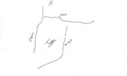
Hi, to stir the pot a bit, as I mentioned, they could refer to the Tayopa zone. The Yaqui and Mayo rivers fit quite well, and curiously enough Arizpe is always associated with the basic Tayopa story ?????? HMMMMMMMMMMMMMMMM

BB?

Don Jose de La Mancha
 

Attachments

  • Stone map.jpg
    Stone map.jpg
    6 KB · Views: 1,141

gollum

Gold Member
Jan 2, 2006
6,729
7,596
Arizona Vagrant
Detector(s) used
Minelab SD2200D (Modded)/ Whites GMT 24k / Fisher FX-3 / Fisher Gold Bug II / Fisher Gemini / Schiebel MIMID / Falcon MD-20
Primary Interest:
All Treasure Hunting
Jose,

Not the correct direction of flow for both rivers.

Buuuuut, a little monkey wrench in the gears could be the word RIO at the right side of the upper waterway (Salt River). In many cases, the letter ""R" or the word "RIO" means that it is a mirror image and everything should be looked at as if in a mirror.

Best-Mike
 

cactusjumper

Gold Member
Dec 10, 2005
7,754
5,388
Arizona
Gentlemen,

I will be happy to show anyone who makes it to the Rendezvous, how exact the Stone Maps are. If you can read a topographic map, and still think the western end of the mountains is not where the maps are drawn from, you may have a vision problem.

You can surmise that they may show another location all you want, but I only ask that you show me such a match. That seems reasonable to me, but then nothing reasonable is ever applied to the maps.

The Priest/Horse map is very suspect, in my mind. In addition to the fact that they publicly came out of the woodwork.......after the fact, so to speak, but the "R" that you speak of seems to be done in the same manner as the zero's that were added by Travis, suggesting that it may have been added after the original carving was done.

While the Stone Maps may have some kind of convoluted code, pointing out real treasure/mine location(s), they are still a simple topographic map. They were drawn from high points in the mountains, but the map showing the trail into the mountains and over the loftiest ridge was drawn from Superstition Peak.

Any code has to be worked from the trail maps. Nothing else is logical. Why create a map of the western end of the range, if the object of interest is somewhere else, not showing or having anything to do with the topography of the maps. :dontknow:

That just gets a bit too convoluted for this poor mind to grasp.

Take care,

Joe Ribaudo
 

Loke

Hero Member
Mar 24, 2010
589
1,383
Republic of Texas
Primary Interest:
All Treasure Hunting
Joe - and I'm ever so sorry for going wildly off the subject - what the heck is your new avatar????
Coquerel?? (am I allowed that word?? _is_ it a word?)

Per
 

cactusjumper

Gold Member
Dec 10, 2005
7,754
5,388
Arizona
Per,

I don't know about a "Coquerel", but a young rooster is called a Cockerel. If my avitar is a youngster, he needs to stay from biker bars if he wants to grow into an old rooster. ;D

Take care,

Joe
 

Loke

Hero Member
Mar 24, 2010
589
1,383
Republic of Texas
Primary Interest:
All Treasure Hunting
*lol* ok, just one more and I'm done with off-subject topics.
How the heck are you allowed to spell out that name?? (c-o-c-k-e-r-e-l).
I tried it first, but then I thought "nah, that's gonna come out as '--deleted--erel' *chuckles* (just as a certain persons lost mine comes out as '--deleted-- Bens Lost Mine')
I had forgotten that you guys call it a 'rooster' - duh!

Per
 

cactusjumper

Gold Member
Dec 10, 2005
7,754
5,388
Arizona
Per,

"How the heck are you allowed to spell out that name?? (c-o-c-k-e-r-e-l)."

I have posted enough times where Jeff knows my heart is pure. :angel7:

You, on the other hand, they probably still have doubts about. :dontknow: :wink:

Take care,

Joe
 

Blindbowman

Bronze Member
Aug 15, 2007
2,042
978
Primary Interest:
All Treasure Hunting
cactusjumper said:
Gentlemen,

I will be happy to show anyone who makes it to the Rendezvous, how exact the Stone Maps are. If you can read a topographic map, and still think the western end of the mountains is not where the maps are drawn from, you may have a vision problem.

You can surmise that they may show another location all you want, but I only ask that you show me such a match. That seems reasonable to me, but then nothing reasonable is ever applied to the maps.

The Priest/Horse map is very suspect, in my mind. In addition to the fact that they publicly came out of the woodwork.......after the fact, so to speak, but the "R" that you speak of seems to be done in the same manner as the zero's that were added by Travis, suggesting that it may have been added after the original carving was done.

While the Stone Maps may have some kind of convoluted code, pointing out real treasure/mine location(s), they are still a simple topographic map. They were drawn from high points in the mountains, but the map showing the trail into the mountains and over the loftiest ridge was drawn from Superstition Peak.

Any code has to be worked from the trail maps. Nothing else is logical. Why create a map of the western end of the range, if the object of interest is somewhere else, not showing or having anything to do with the topography of the maps. :dontknow:

That just gets a bit too convoluted for this poor mind to grasp.

Take care,

Joe Ribaudo

and yes we know . you have told us over and over the dagger points north ... lol .. your wrong but you stand by what you believe ...i can give you that much ...

joe i got to tell you ..

the dagger ,, is not a dagger ... look close friend .. learn from your mistakes
 

Nov 8, 2004
14,582
11,942
Alamos,Sonora,Mexico
Primary Interest:
All Treasure Hunting
Morning Gully, you posted --> Not the correct direction of flow for both rivers.

*******************************
Where on the stone maps does it show dirrection of flow?

I have never even thought of this until now, but I am begining to find many coincidental factors. HMMMM !

Don Jose de La Mancha
 

gollum

Gold Member
Jan 2, 2006
6,729
7,596
Arizona Vagrant
Detector(s) used
Minelab SD2200D (Modded)/ Whites GMT 24k / Fisher FX-3 / Fisher Gold Bug II / Fisher Gemini / Schiebel MIMID / Falcon MD-20
Primary Interest:
All Treasure Hunting
Real de Tayopa Tropical Tramp said:
Morning Gully, you posted --> Not the correct direction of flow for both rivers.

*******************************
Where on the stone maps does it show dirrection of flow?

I have never even thought of this until now, but I am begining to find many coincidental factors. HMMMM !

Don Jose de La Mancha

Typically on maps, a dagger/knife tip points to the North. That would make the rivers on the maps oriented East-West.

Mike
 

cactusjumper

Gold Member
Dec 10, 2005
7,754
5,388
Arizona
Mike,

There is no doubt that the point of the dagger is oriented to the north. On the other hand, It's obvious that the hilt is pointing towards the trail to the heart, which is to the east.

There are many people posting here, who have never been in the Superstitions, or if they have, never left the marked trails.....the one or two times they have taken a hike. Even so, they talk as if they have some kind of expertise or inside knowledge.

Those same people seem unable to read a simple topographic map. For instance, if you can read such a map, you would have no doubts that the Stone Maps are orientated with the start of the trail over the main mountain being at the bottom, which is south, and the point of the dagger is at the top, which is to the north.

You have explained the rule, many times, for the initial approach to reading the Stone Maps. Occam's Razor, or lex parsimoniae. Being a simple man, I slide into that mode rather easily. The answer is just too simple for some of the greater minds here. There just has to be a complicated code that points to ancient civilizations or the patterns of the stars, or a biblical code.....etc.

If my solution is correct, how can they demonstrate their superior intellect? They can't just agree with me, because I am a dumb.......burro, compared to just about anyone. I, of course, have no problem with that assessment, but the Stone Maps are what they are, no matter who tries to twist or turn them into something other than a simple map. ::)

Now if there is some kind of code that pertains to the actual map, :dontknow:
I would like to see that forthcoming. However, that code has to be followed off of the maps, as I have laid them out. Work on that premise and you may just answer the real puzzle.

Just one man's opinion.

Take care,

Joe
 

Nov 8, 2004
14,582
11,942
Alamos,Sonora,Mexico
Primary Interest:
All Treasure Hunting
Gully, you posted -->Typically on maps, a dagger/knife tip points to the North. That would make the rivers on the maps oriented East-West.
************************

A bit of freedom in interpretation is allowed and used here??

Typically is not exact enough. Remember 'your' "R" factor, So they run west > East or East > West or actually N>S ?


Don Josed de la Mancha
 

Top Member Reactions

Users who are viewing this thread

Top