The Square Round Table

Kace

Bronze Member
Aug 15, 2017
2,099
4,910
Detector(s) used
Whites DFX, Whites Bullseye 2 Pointer, Audio 200 D Headphones,
Garrett AT MAX, Garrett Pro-Pointer AT, MS-3 Headphones,
Lesche Digger, Lesche Shovel, 4' T Handle Probe.
GoPro, RC Truck, Drone.
Primary Interest:
Other

franklin

Gold Member
Jun 1, 2012
5,036
7,168
Detector(s) used
Garrett ADS-7X, Fisher Two Box M-Scope, Mother Lode Locator, Dowsing Model 20 Electroscope, White's TM808, White's TM900, Inground Scanners
Primary Interest:
All Treasure Hunting
Has Anyone Heard From Barn? He usually checks in after his Sunday Hunt.

I hope he's okay.

Kace

Most likely disappointed with the ground scanner. Myself I believe they are a piece of high priced junk.
 

franklin

Gold Member
Jun 1, 2012
5,036
7,168
Detector(s) used
Garrett ADS-7X, Fisher Two Box M-Scope, Mother Lode Locator, Dowsing Model 20 Electroscope, White's TM808, White's TM900, Inground Scanners
Primary Interest:
All Treasure Hunting
Barn, if the magnetometer does not work out for you, have you ever considered trying an Arc Geologger hooked up to a deep seeker like a Whites 808? Our 808 has a cave mode which is nice to have also, and with the geologger hooked up it will look very deep. You can view it in real time with a laptop hooked up also.

View attachment 1605122

L.C.

No luck with that machine either? I have not seen any instrument on the market today that will penetrate the ground more than five feet except for The Fisher M-Scope two box.
 

barnhse

Full Member
Oct 7, 2014
132
336
NE Texas
Primary Interest:
All Treasure Hunting
Has Anyone Heard From Barn? He usually checks in after his Sunday Hunt.

I hope he's okay.

Kace
Hi All,

So very sorry I have been so quiet.
After my first experience with a magnetometer on Sunday, I went to see the new Jurassic World movie with two of the wife's grandkids.
Then on Monday, my sweat-shop job had me work straight from 5 am to 8 pm...no wonder I want to find gold and say goodbye to that.

The bottom line is that I will have to call the magnetometer folks and get more advice on how to use that stick.

Since most folks (like me) usually use normal metal detectors or Pulse Induction detectors, this thing is really weird.
It looks like a toy from the Dollar Store.
$300 for a month's rental, and the thing weighs 3 pounds, including the shipping box and box wrapping paper.
So have my doubts...I hope I am wrong...maybe it is a magic wand after all.

One good thing...it is LOT easier than digging holes with my hand auger! :laughing7:

Here are some pics, I hope they don't make this post super long.

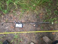
Here is what the stick looks like:
IMG_0181.JPG

For a "grid" that would s-t-r-e-t-c-h way over my primary and secondary target areas, I figured I would take a measurement every 6 feet.
I would walk long-ways first, then walk up-and-down ways.
I didn't bring my 100-foot tape measure, I forgot (so I am old).
So I had to MacGyver a measuring thingee.

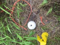
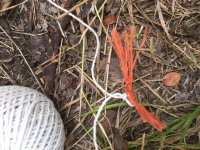
I used a couple of survey flags, a string ball, and a piece of orange plastic rope I found on the road going to the marsh.
IMG_0182.JPG

I had a 16-foot tape measure, so I put two of the survey flags 12 feet apart to easily measure 12-foot sections of the string.
Then I tied (using a slip knot) a short section of the orange rope to 12-foot sections of the string as a marker).
I did this until I ran out of the orange rope used for markers.
IMG_0183.JPG

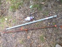
I selected two 2-foot pipes (I have so many extension pipes out there for my hand auger) to use as a guide for a 2-foot wide "grid" path.
The bottle is an empty water bottle (yes, I stay hydrated out there) with my measuring string and markers wrapped around it.
IMG_0186.JPG

I had enough of my MacGyver'd string to tie to each end of the pipes.
This allowed me to s-t-r-e-t-c-h my grid over both my primary and secondary target areas.
I would search 2 "paths", move the pipes over, and repeat.
IMG_0188.JPG
Of course, the shade didn't last long.

I recorded measurements at every orange rope marker, and in the middle of the markers...so every 6 feet.
I searched 6 paths in all on Sunday...twice...once holding the magnetometer vertically, and then again wiggling the stick around to get the max reading.
I only searched the long-ways, not any up-and-down ways.
After thinking about it, maybe using this marked-string technique, I may not even have to search the up-and-down ways after all.
No, I didn't know what I was doing. :dontknow:

I did record all my measurements and won't bore you with all the data or a graph.
The data did not make any sense.
I first need to learn the technique for getting the most accurate measurements by calling the rental place.
My vacation was approved for next week, so I can do all my measurements next week and return the stick.

“Previous journeys in search of treasure have taught me that a zigzag strategy is the best way to get ahead.”
― Tahir Shah, House of the Tiger King: The Quest for a Lost City
 

Last edited:

Kace

Bronze Member
Aug 15, 2017
2,099
4,910
Detector(s) used
Whites DFX, Whites Bullseye 2 Pointer, Audio 200 D Headphones,
Garrett AT MAX, Garrett Pro-Pointer AT, MS-3 Headphones,
Lesche Digger, Lesche Shovel, 4' T Handle Probe.
GoPro, RC Truck, Drone.
Primary Interest:
Other
I'm glad you're okay Barn! I was worried about ya!

I hope the rental place can help you... it does kinda look like a magic wand! lol!

Thanks for the updates and pics... I look forward to it!

Kace
 

Kace

Bronze Member
Aug 15, 2017
2,099
4,910
Detector(s) used
Whites DFX, Whites Bullseye 2 Pointer, Audio 200 D Headphones,
Garrett AT MAX, Garrett Pro-Pointer AT, MS-3 Headphones,
Lesche Digger, Lesche Shovel, 4' T Handle Probe.
GoPro, RC Truck, Drone.
Primary Interest:
Other
Most likely disappointed with the ground scanner. Myself I believe they are a piece of high priced junk.

After him having to bargain Father's Day gifts with his wife, I Really Hoped That would work!

How far down have you had good results with the Fisher 2 Box?

Kace
 

OP
OP
L.C. BAKER

L.C. BAKER

Silver Member
Sep 9, 2012
3,805
4,643
Nebraska City, Nebraska
Primary Interest:
Other
No luck with that machine either? I have not seen any instrument on the market today that will penetrate the ground more than five feet except for The Fisher M-Scope two box.

We have found targets with ours. It has been the deepest machine we have used so far, but in our case, there has been nothing important buried deeper than five feet (yet). I am not familiar with the Fisher. The two box is easier to use in the grassy areas, but not so good in the brushy ones. We have to use something smaller to weave around the trees. I am holding out for GPR. Our trail has produced using a selection of detectors dating back to the 1970's and it has gotten better with time and technology. The thing that has helped us the most is our growing knowledge of the symbolism and their use of it on the maps.

L.C.
 

Last edited:
OP
OP
L.C. BAKER

L.C. BAKER

Silver Member
Sep 9, 2012
3,805
4,643
Nebraska City, Nebraska
Primary Interest:
Other
Barn, besides the obvious question of why did the map get published, I would ask myself who made the map, why did they need a map, and who was the map made for? Did they make it for themselves? In all of the cases, I have studied about these men they use a line to bury the goods on. That line may extend from the place you are standing to another place you can see from there, or it may extend for miles to the other place. The map is really just a picture of that line and how to find it. A map is a key to finding those lines and in our case, it was also how they hid the starting point. You had to have the map(s) to find it. They buried headings and distances in the ground because without the starting point they are useless. The trusted wealthy K.G.C. members who buried these caches had no personal intent to recover the wealth for themselves but to use it later to overthrow the Lincoln regime they felt they had lost control of the country to. When the O.A.K. was spawned they did just that very thing, but with some of the cache money and dirty politics and investing not guns and bullets as they had first conceived. RETRIBUTION came and went quietly until the litigation with the Federal Government started in the early 1900's. There was also more than one regrouping and renaming of the K.G.C. after 1863 and some members were cut out even if they did not know it, and continued living in their own little bubbles. I believe in some cases whole states and all of their castles were removed without their knowledge of the severance. In your case, there is a good chance that they were savvy about what was left there in the 1920's.
"In order to feed the demand for capital to finance construction, bond sellers courted retail investors, selling them shares in these commercial ventures as well as bonds backed by the properties -- a precursor to the modern markets' complex forms of securitization. Previously, only institutional investors, such as banks and insurance companies, were the sources of such funds.
"Demand was such that a real estate securities exchange was created in 1929 and commercial mortgage-backed securities quickly grew into one of the largest classes of investment assets of the 1920s, raising more than $4.1 billion from 1,090 bond offerings between 1919 and 1931. Among the reasons for this rapid growth was the presence of small investors who, it turned out, relied on poorly supported assertions of asset value provided by a few large intermediaries in a market with little centralization or regulatory oversight. “The public was the obvious but critical third party in the real estate securities boom of the 1920s,” Goetzmann and Newman write. “It is not clear whether building companies viewed the public as an attractive (if ignorant) source of capital or as a lender of last resort. Anecdotal evidence suggests the latter, as do the empirical results of this study."
Securitization in the 1920s

The question is, did they use the cache we are looking for to invest or did they need it too? What I do know for sure is that they made billion$ more and they died filthy rich with secrets.

L.C.
 

Last edited:

barnhse

Full Member
Oct 7, 2014
132
336
NE Texas
Primary Interest:
All Treasure Hunting
Barn, besides the obvious question of why did the map get published, I would ask myself who made the map, why did they need a map, and who was the map made for? Did they make it for themselves? In all of the cases, I have studied about these men they use a line to bury the goods on. That line may extend from the place you are standing to another place you can see from there, or it may extend for miles to the other place. The map is really just a picture of that line and how to find it. A map is a key to finding those lines and in our case, it was also how they hid the starting point. You had to have the map(s) to find it. They buried headings and distances in the ground because without the starting point they are useless. The trusted wealthy K.G.C. members who buried these caches had no personal intent to recover the wealth for themselves but to use it later to overthrow the Lincoln regime they felt they had lost control of the country to. When the O.A.K. was spawned they did just that very thing, but with some of the cache money and dirty politics and investing not guns and bullets as they had first conceived. RETRIBUTION came and went quietly until the litigation with the Federal Government started in the early 1900's. There was also more than one regrouping and renaming of the K.G.C. after 1863 and some members were cut out even if they did not know it, and continued living in their own little bubbles. I believe in some cases whole states and all of their castles were removed without their knowledge of the severance. In your case, there is a good chance that they were savvy about what was left there in the 1920's.
"In order to feed the demand for capital to finance construction, bond sellers courted retail investors, selling them shares in these commercial ventures as well as bonds backed by the properties -- a precursor to the modern markets' complex forms of securitization. Previously, only institutional investors, such as banks and insurance companies, were the sources of such funds.
"Demand was such that a real estate securities exchange was created in 1929 and commercial mortgage-backed securities quickly grew into one of the largest classes of investment assets of the 1920s, raising more than $4.1 billion from 1,090 bond offerings between 1919 and 1931. Among the reasons for this rapid growth was the presence of small investors who, it turned out, relied on poorly supported assertions of asset value provided by a few large intermediaries in a market with little centralization or regulatory oversight. “The public was the obvious but critical third party in the real estate securities boom of the 1920s,” Goetzmann and Newman write. “It is not clear whether building companies viewed the public as an attractive (if ignorant) source of capital or as a lender of last resort. Anecdotal evidence suggests the latter, as do the empirical results of this study."
Securitization in the 1920s

The question is, did they use the cache we are looking for to invest or did they need it too? What I do know for sure is that they made billion$ more and they died filthy rich with secrets.

L.C.

Hi L.C.,

I would L-O-V-E to know who made the map...and if there was a bird's eye view version of the map, too.
Sad to say, I have no clue where to even start that research.

All I knew (and all I still know) was to try to find a KGC cache...
and it had to be within driving distance for me because all the KGC caches were hard to find and get to.
I accepted that it would take many trips to any potential KGC dig site and would take me a really long time to retrieve anything.

The only faint glimer of hope I had for finding a KGC cache near me was the 3 page story/map in that stupidly-over-priced, poorly witten book...
then when I found the marsh it must be on, the story made more and more sense...
and when I traced the ship and wagon route and why they would go that way, it made even more sense, too.
In fact, the more I learn, the more it makes sense.

Hence, over time, I convinced myself the story/map just might be true after all. :)

"Hope is definitely not the same thing as optimism.
It is not the conviction that something will turn out well,
but the certainty that something makes sense,
regardless of how it turns out."
— Vaclav Havel
:icon_sunny:

Anyway, I still plan to see if the cache is there...that way I will know. (unless the marsh kills me first...it tries, y'know)
There is only one place in the whole gosh-dang marsh that matches that silly map.
Livin' the dream.
 

Last edited:

franklin

Gold Member
Jun 1, 2012
5,036
7,168
Detector(s) used
Garrett ADS-7X, Fisher Two Box M-Scope, Mother Lode Locator, Dowsing Model 20 Electroscope, White's TM808, White's TM900, Inground Scanners
Primary Interest:
All Treasure Hunting
After him having to bargain Father's Day gifts with his wife, I Really Hoped That would work!

How far down have you had good results with the Fisher 2 Box?

Kace

Kace, Where there is not much iron ore such as in Bedford County Virginia which has a ton of iron ore everywhere. A two box or any metal detector is useless. But in normal ground I have used the Fisher M-Scope with good results. It has two frequencies. One of the frequencies I have picked up an underground storm drain that is about two feet in diameter by maybe 15 ir 20 feet long at a depth of 18 feet. The other frequency will go about one half that distance for a similar object. I have used the TM-808, TM-900 and the Garrett Deep Seeking two box with all of these I have been able to only pick up between 4 and 5 feet in depth. Others can make other claims but they will have to show me first before I will believe it. A White's TM will pick up a railroad car in air test about 10 feet and that it is it, a wall of steel.
 

OP
OP
L.C. BAKER

L.C. BAKER

Silver Member
Sep 9, 2012
3,805
4,643
Nebraska City, Nebraska
Primary Interest:
Other
Hi L.C.,

I would L-O-V-E to know who made the map...and if there was a bird's eye view version of the map, too.
Sad to say, I have no clue where to even start that research.

All I knew (and all I still know) was to try to find a KGC cache...
and it had to be within driving distance for me because all the KGC caches were hard to find and get to.
I accepted that it would take many trips to any potential KGC dig site and would take me a really long time to retrieve anything.

The only faint glimer of hope I had for finding a KGC cache near me was the 3 page story/map in that stupidly-over-priced, poorly witten book...
then when I found the marsh it must be on, the story made more and more sense...
and when I traced the ship and wagon route and why they would go that way, it made even more sense, too.
In fact, the more I learn, the more it makes sense.

Hence, over time, I convinced myself the story/map just might be true after all. :)

"Hope is definitely not the same thing as optimism.
It is not the conviction that something will turn out well,
but the certainty that something makes sense,
regardless of how it turns out."
— Vaclav Havel
:icon_sunny:

Anyway, I still plan to see if the cache is there...that way I will know. (unless the marsh kills me first...it tries, y'know)
There is only one place in the whole gosh-dang marsh that matches that silly map.
Livin' the dream.

Spoken like a true treasure hunter Barn!

L.C.:occasion14:
 

Kace

Bronze Member
Aug 15, 2017
2,099
4,910
Detector(s) used
Whites DFX, Whites Bullseye 2 Pointer, Audio 200 D Headphones,
Garrett AT MAX, Garrett Pro-Pointer AT, MS-3 Headphones,
Lesche Digger, Lesche Shovel, 4' T Handle Probe.
GoPro, RC Truck, Drone.
Primary Interest:
Other
Kace, Where there is not much iron ore such as in Bedford County Virginia which has a ton of iron ore everywhere. A two box or any metal detector is useless. But in normal ground I have used the Fisher M-Scope with good results. It has two frequencies. One of the frequencies I have picked up an underground storm drain that is about two feet in diameter by maybe 15 ir 20 feet long at a depth of 18 feet. The other frequency will go about one half that distance for a similar object. I have used the TM-808, TM-900 and the Garrett Deep Seeking two box with all of these I have been able to only pick up between 4 and 5 feet in depth. Others can make other claims but they will have to show me first before I will believe it. A White's TM will pick up a railroad car in air test about 10 feet and that it is it, a wall of steel.

Thanks franklin.... I've never used those....That's Good To Know. I've only used GPR's, Game Finders, Metal Detectors, Aqua Views and Drones... Oh and my trusty GoPro and Extendable Mirror to look for snakes before I go in! lol!!

Kace
 

Last edited:

Kace

Bronze Member
Aug 15, 2017
2,099
4,910
Detector(s) used
Whites DFX, Whites Bullseye 2 Pointer, Audio 200 D Headphones,
Garrett AT MAX, Garrett Pro-Pointer AT, MS-3 Headphones,
Lesche Digger, Lesche Shovel, 4' T Handle Probe.
GoPro, RC Truck, Drone.
Primary Interest:
Other
Hi L.C.,

I would L-O-V-E to know who made the map...and if there was a bird's eye view version of the map, too.
Sad to say, I have no clue where to even start that research.

All I knew (and all I still know) was to try to find a KGC cache...
and it had to be within driving distance for me because all the KGC caches were hard to find and get to.
I accepted that it would take many trips to any potential KGC dig site and would take me a really long time to retrieve anything.

The only faint glimer of hope I had for finding a KGC cache near me was the 3 page story/map in that stupidly-over-priced, poorly witten book...
then when I found the marsh it must be on, the story made more and more sense...
and when I traced the ship and wagon route and why they would go that way, it made even more sense, too.
In fact, the more I learn, the more it makes sense.

Hence, over time, I convinced myself the story/map just might be true after all. :)

"Hope is definitely not the same thing as optimism.
It is not the conviction that something will turn out well,
but the certainty that something makes sense,
regardless of how it turns out."
— Vaclav Havel
:icon_sunny:

Anyway, I still plan to see if the cache is there...that way I will know. (unless the marsh kills me first...it tries, y'know)
There is only one place in the whole gosh-dang marsh that matches that silly map.
Livin' the dream.


Barn are you familiar with Okie's Blog? It's not a discussion forum like here... it's a blog and research site only.

He's not a KGC Mega Vault Believer and he does not believe in any Template or Dalton and Howk Stories but he's got a lot of information on his blog that you might find useful. He's more into cache, outlaw and Spanish treasure. In some cases what some might call a KGC Treasure, he might call it Spanish or Outlaw.

He does discuss Dalton and Howk though and has a lot of letters and maps from Howk and Dalton as well as their history. If I remember right he used to be a believer but proved to himself otherwise.

Anyway the information on his blog I think is useful to any type of treasure hunter regardless of beliefs of origin.

Like I said before... I Think Treasure is Treasure...It Really Doesn't Matter Where It Came From To Me.

Kace
 

barnhse

Full Member
Oct 7, 2014
132
336
NE Texas
Primary Interest:
All Treasure Hunting
Hi All,

I am not familiar with Okie's Blog, Kace...I'll Google it and have a peek at it.

Regarding my rented magnetometer...."Now we're cookin'!"
(I also say that every July and August here in the Texas heat) :tongue3:
------------------------------------------------------
I called the magnetometer folks and talked to their technical support person, Bill.
He was a nice old fella, like me.

Bill explained the quickest way to get the maximum read on my rented magnetometer.
I wasn't doing it right. (of course, their magnetometer operating instructions were hard for me to understand, with no pictures either…and nothing on YouTube)
Since I didn't know the right peak measurement technique, then no wonder my readings from last Sunday didn't make any sense.

Bill, said that it "should" take me about 30 seconds to measure each point.
So I figure 1 minute for me since I am old and slow.

I calculate ~120 points to go over all three of my search areas completely.
Twice that to walk from point to point, record the numbers, layout my grid line, drink water, rest in the shade, etc.
So theoretically, I can make a complete pass on all three target areas in less than one day.

Then I can go home and enter all my data in a spreadsheet, play with graphs, and try not to make typos or be stupid.
Then the next day, I would go back to the marsh to search better in the best areas. (theoretically)
------------------------------------------------------
I told Bill the dimensions of the safe and how deep it was buried (top of safe is 20 feet down from the surface).
Bill said no problem. (ha, if he only knew all the problems I have had so far)
For that size safe (3X3X4 feet), my rented magnetometer should detect it 40 to 50 feet down.

His only hesitation was that the soil was full of hematite, so he really didn't know how that would affect the reading values.
(here comes the loophole, I thought) :wink:

However, the magnetometer measured values will show the difference in iron affecting the magnetic field of the earth.
A safe made of wrought iron "should" more than offset the hematite.

Additionally, the actual numerical measurement values shouldn't be a problem if they are off with the hematite sand...if the hematite sand was fairly constant across the search area.
I am to look at only the difference in the measurement values.
------------------------------------------------------
Most all my previous measurements from last Sunday were like 48.xyz numbers.
Bill said for the safe at 20ish feet down, the difference should
be like between 48.1xx vs. 48.2xx, if I was lucky
(or like between 48.125 and 48.150, if I was unlucky).
------------------------------------------------------
BTW, I know where a long pipeline is buried in the swamp, so I can first test the magnetometer there to see if I am being sold (er, rented) a bunch of "swamp gas".
------------------------------------------------------
What did the paper clip say to the magnet? I find you very attractive.
What did the KGC safe say to the magnetometer? Find me if you can.
 

Last edited:

barnhse

Full Member
Oct 7, 2014
132
336
NE Texas
Primary Interest:
All Treasure Hunting
Hi All,

I captured magnetometer numbers today on 2 of my 3 target areas.

So far, I don't see the safes.

Tomorrow will mag scan my 3rd and last target area.
 

OP
OP
L.C. BAKER

L.C. BAKER

Silver Member
Sep 9, 2012
3,805
4,643
Nebraska City, Nebraska
Primary Interest:
Other
I like the Okie blog you mentioned Kace, a lot of info on there to be had. I have had another project going this week that has been time-consuming. I thought surely carrying a body wrapped in a trash bag into my garage would have aroused my neighbor's suspicion yesterday evening..... ???

4th,2018.jpg
 

Last edited:

Kace

Bronze Member
Aug 15, 2017
2,099
4,910
Detector(s) used
Whites DFX, Whites Bullseye 2 Pointer, Audio 200 D Headphones,
Garrett AT MAX, Garrett Pro-Pointer AT, MS-3 Headphones,
Lesche Digger, Lesche Shovel, 4' T Handle Probe.
GoPro, RC Truck, Drone.
Primary Interest:
Other
Hi All,

I captured magnetometer numbers today on 2 of my 3 target areas.

So far, I don't see the safes.

Tomorrow will mag scan my 3rd and last target area.

Hoping For The Best!

Kace
 

Kace

Bronze Member
Aug 15, 2017
2,099
4,910
Detector(s) used
Whites DFX, Whites Bullseye 2 Pointer, Audio 200 D Headphones,
Garrett AT MAX, Garrett Pro-Pointer AT, MS-3 Headphones,
Lesche Digger, Lesche Shovel, 4' T Handle Probe.
GoPro, RC Truck, Drone.
Primary Interest:
Other
I like the Okie blog you mentioned Kace, a lot of info on there to be had. I have had another project going this week that has been time-consuming. I thought surely carrying a body wrapped in a trash bag into my garage would have aroused my neighbor's suspicion yesterday evening..... ???

View attachment 1607106

Always Nice To Know That Your Neighbors Are Keeping A Watchful Eye! ROFL!

Kace
 

barnhse

Full Member
Oct 7, 2014
132
336
NE Texas
Primary Interest:
All Treasure Hunting
Hoping For The Best!

Kace

Today, Sunday, I remeasured all my measurements for my target areas 1 and 2 again.
I wanted to make sure I was doing everything right before moving to my last target area.

Of course, measurements were different, but I increased my magnetometer skill level.
If I were kind, I'd make a YouTube video about how to do it.
Right now, the Texas weather is too hot for me to be kind.

Anyway, I was in the marsh from 6 am to 2 pm today honing my "skills"...my back doesn't like me tonight.

After measuring multiple times in the Texas sun, I now have exactly one place in combined target areas 1 and 2 that might have something down there.
Problem is, that one place doesn't match the map too well...so I have my doubts.
I can dig it later.

Anyway, now that I am "skilled-up" with the magic-wand magnetometer, measuring target area 3 should go quickly tomorrow.

I have all week off...wish I could use it traveling to NM for the Fenn treasure, I would only need one search-day.
But it takes two days (each way to get there)...and next Saturday is "visit-elderly-mom-on-Saturday-weekend"...oh well.
 

OP
OP
L.C. BAKER

L.C. BAKER

Silver Member
Sep 9, 2012
3,805
4,643
Nebraska City, Nebraska
Primary Interest:
Other
Barn sounds to me like you have things going just fine and you are getting it done. Don't be discouraged by any negative results in the field. It is ALL good information to a treasure hunter because you know more than you did before you tried something out that didn't quite pan out. It requires a lot of passion and patience and I believe you have plenty of both.
Good Luck on your quest.

L.C.
 

Last edited:

Top Member Reactions

Users who are viewing this thread

Top