UncleMatt
Bronze Member
- Jul 14, 2012
- 2,389
- 2,530
- Detector(s) used
- Garrett Infinium & Gold Bug II, Bazooka Super Prospector Sluice
- Primary Interest:
- All Treasure Hunting
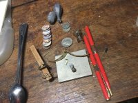
nice ground work
It appears Big Tujunga Reservoir is south of HWY 14 on the other side of the highway far from where the parcels were mapped out by Garry in post #178. Are we sure about that mapping Garry?


.jpg")


I like my wine with a little reading material....quit stalling....<img src="http://www.treasurenet.com/forums/attachment.php?attachmentid=1094740"/>[/
Ok stop it you two. You are fogging up my screen.