Abandoned village hunt! with, research, mapping and lidar tips

DownEast_Detecting

Sr. Member
Feb 26, 2020
428
1,101
Maine
Detector(s) used
Garrett AT Pro, Minelab CTX 3030
Primary Interest:
All Treasure Hunting
ok this is going to be a doozy. i apologize in advance but if you like history, maps, research and relics stay with me. This is my abandoned village site, there is not a lot of info on it. But people were here from 1820-1940. It use to be the main road that connected two larger towns back in the day. It had its own school house and general store with a dance hall on the second floor(red circle). Both the vertical and horizontal roads are just paths now. (See map below) Some think after the highway was built. The reason to take this road was gone. and the village failed. Or it could be that in some spots if you dig down past a foot you hit ledge. So their farms could have failed. Or all the men going off to the civil war. (this is the place i found my model 1826 shoulder belt plate and infantry officers cuff buttons) Some not coming back to their wives and kids. Others coming back to get their family and move to better farmland. Either way everybody left by 1940 i think most were gone at the end of the 19th century. Its a large site. around 1 mile from the large barn cellar hole at the bottom (light blue) to the house cellar hole at the top(white circle). I live pretty close so i always am just picking one home site and search around it for an hour or so. This weekend i put in the longest hunt ive done. 3 hours on Friday, 7 hours on Saturday and 2 hours this morning. I searched ALL over and got some first's and great finds. Im amazed how much ive gotten since i know its been hunted by others before. i ran into one guy last summer.
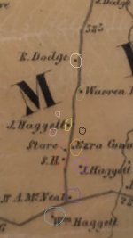
Below is a topo map from 1857 showing most of the houses and school house and store with the 2nd floor dance hall. Next to that is the lidar from the same area. I have circled the different buildings in corresponding colors so you can see their cellar holes on the lidar map. Also there were several mica, feldspar and mineral mines. Some bigger ones just south of map. There are some smaller ones (circled in pink) on maps below. also the town has a rather large dump (circled in black) in edition to the smaller individual pits and privies.
This took me most of the second have of the day to clean finds, picture them, and put together this post. Maybe i went a little far, but i like to be thorough. and i know some of you enjoy the history and maps and such.
1E321E56-6BD0-477F-BD97-EE9DAA07DAD9.jpeg
19235623-D9FC-45D1-A503-F27C0CE711DE.jpeg


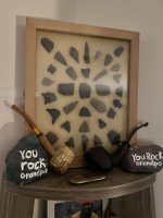
and now here are my finds
BD9975F3-7DB0-4247-BEB4-6EE983A20BCE.jpeg

all of them together
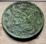
6B2C3302-115B-477C-AD6D-469B371E3E47.jpeg
A37ACCB9-0FC2-497F-9118-117AAB55E2D7.jpeg

#1 1842 large cent
#2 1865 2 cent piece again in amazing condition, just like my 1871 Indian head penny i found here. There must be something in the soil up on top of the hill.

CCD4471E-A176-4159-9FFC-06D7DA6043B1.jpeg
F686DF77-549E-4B5E-B865-768AF1519A5E.jpeg

#3 1929 mercury dime and #4 old Chinese coin?
#5 1891 Indian head penny and #5 again whoops i think this thing is from one of the first combination pad locks, only had 8 numbers? haha #6 spoon bowl

9F025753-FB24-4732-8ED7-BFFD80E78C60.jpeg
7C4137CE-A2CE-4F7F-B7B8-99FEFDC7BC3B.jpeg

#7 Spoons. amazing how many times ill find a spoon from going into the backyard areas finding the biggest boulder and searching all around it. I figure people must have had picnics on the rock.
#8 baby spoon handle? its small. #9 is the biggest silverware piece i have ever found. It must of been a serving spoon or something. Also someone definitely carved a P into the back right?

20EA138E-BE2E-4C39-B90E-27F272C39187.jpeg
4ACF9528-D455-4EF3-BA17-B913A3587DB3.jpeg

#10 Crotal bell how old im not sure. has a number 2 stamped at the top. and i swear there is a 1 stamped near the slit. # 11 is a women's Timex watch. Not super old probably 1960's? im not sure.
# 12 is a bell. I found this in sort of the backyard of the school area. In my mind it was on the outside to ring. to get kids back to school. But who knows. #13 is a friggin lobstah pickah guy.

49F4F930-02BC-4542-B334-5B2D8E7D580E.jpeg
7F334B66-B6A7-41B5-8FB2-749C578FE4C8.jpeg

#14 is maybe pocket watch cover? does it have another P carved into it? it was in the same lot as the serving spoon with a P on it too. Maybe the same persons.
#15 i dont know. Toy wheel? its heavy.
#16 bits of mica. I fInd lots of this in house lots digging. There was a mica and feldspar mine in this town. #17 some type of Santa Claus pin? #18 thought it might be modern but could also be on old 2 piece shoe button or something not sure.

F31CF78C-87BA-4054-B383-3ACB722A552B.jpeg
46FDB117-F205-479F-AA79-A92C37925322.jpeg

#19 #20 #21 #22 Flat buttons not sure on age. #21 still has some gold gilt on it. #23 im not sure. Thought it was a modern snap from jeans, but not sure. #24 is probably the best back condition button ive ever dug. Still has all its gilt. I had a heart attack when i saw it in the dirt at first. Thought it was a gold coin.
I keep track of all my finds on GPS mapping program. This is a 1900 topo map from that app. all numbers correspond to my finds above.
Significant finds from previous hunts
#25 1871 Indian head penny
#26 US army Model 1826 Enlisted mans shoulder belt plate( civil war eagle plate)
#27 infantry officers coat cuff buttons(2)

B264E9E9-C272-430A-9C44-2F6D0808251C.jpeg

and all the junk.

CE1432E8-362F-4F85-874C-79E9A090DBAE.jpeg
FA5B1621-120F-47D8-8ACB-82A8EC706498.jpeg

This is the towns dump on left. (circled in black on map.) Every home or building has a little dump pit out back somewhere but this is a pretty large dump for the whole village.
one of the nicer cellar holes on right.(circled light purple on map)

8B945204-FB33-46B7-9873-07C8AF90D286.jpeg
4057E9C8-79BD-44C3-9B28-77E2CCC8CAE6.jpeg

one of the smaller mica or feldspar cuts on left. Exploratory dig maybe. (circled in pink on map)
spoil pile from the smaller mine on right


589ED882-D481-4CE2-A2DC-3F9618ED4C03.jpeg

left over equipment from smaller mica or feldspar mine. top of steam boiler?
 

Attachments

  • F574FD22-D2B0-4EB8-9DFD-C2B0DCAD5328.jpeg
    F574FD22-D2B0-4EB8-9DFD-C2B0DCAD5328.jpeg
    120.1 KB · Views: 89
  • 558F3168-C5D8-4F4F-A835-B70B124D13E8.jpeg
    558F3168-C5D8-4F4F-A835-B70B124D13E8.jpeg
    257.5 KB · Views: 32
Last edited:
Upvote 36

pepperj

Gold Member
Feb 3, 2009
37,797
140,326
🥇 Banner finds
1
Detector(s) used
Deus, Deus 2, Minelab 3030, E-Trac,
Primary Interest:
Relic Hunting
Well done on the recoveries.
The 2 cent piece really survived well compared to the IH pennies.
Nice layout of the post a lot of time was spent documenting the finds and pictures.
Here's the 1895 bicycle lock, very cool.
Screen Shot 2023-07-31 at 6.54.42 AM.png
 

grasshopper

Bronze Member
Aug 13, 2007
1,827
2,733
Upstate NY
🥇 Banner finds
1
Detector(s) used
XP Deus/Deus 2
Primary Interest:
All Treasure Hunting
Great finds and interesting post!!
Is that an app you're using for the lidar? Just curious. I use lidar data at work so I always do my sleuthing with GIS software, but am interested in how other people go about it.
 

OP
OP
DownEast_Detecting

DownEast_Detecting

Sr. Member
Feb 26, 2020
428
1,101
Maine
Detector(s) used
Garrett AT Pro, Minelab CTX 3030
Primary Interest:
All Treasure Hunting
That item you call a steam boiler too kind of looks like part of a still.
it could be. I just know it was next to the small mining site. so related to their operation.

Well done on the recoveries.
The 2 cent piece really survived well compared to the IH pennies.
Nice layout of the post a lot of time was spent documenting the finds and pictures.
Here's the 1895 bicycle lock, very cool.
Thanks pepper! So up on the hill coins seem to do way better. Different soil or less water in the ground? This is the IHP i dug awhile ago up on the hill. Same as the 2 cent piece. Friggin mint guy. That Large cent was down in the flat, lower elevation.
Yes that's my lock alright! i like it, simple.
9237A6D0-5EEE-4E58-8DBD-2F90AC97D573.jpeg

Great finds and interesting post!!
Is that an app you're using for the lidar? Just curious. I use lidar data at work so I always do my sleuthing with GIS software, but am interested in how other people go about it.
thanks grasshopper, First off i use the gaia gps app to keep track of EVERYTHING!!! they dont even get that they made the metal detectors dream site/app. I mark all my sites and cellar holes and all my finds. Dig a good target? stop dont move pull out your phone and mark a way point at your location. when you click on them (they appear as way points) you can have pictures notes about them. Lat and Long, elevation. I put pictures of the lidar cellar holes attached to the home site way points. And pics of my finds clean and in the hole. Just a great way to try and get a picture of what was going on in a large town like this. But useful for all finds/sites. You can just keep all the info on these sites withing the app. Pretty sweet. Plus you can put on a 1900 historic topo and put the slider on half way transparently. With up to date satellite behind it. You might have to pay for that feature not sure. (i do pay 40 or something a year) But that means you can look all over the place. zoom in if there is a road or a black square on the 1900 topo and nothing but woods on the satellite. Boom you have a potential site. for there was a building or road that is no longer there. I have over 300 sites within 50 miles of me. Most just from doing that. Then do more research and find out which houses are really old. Of course they are only potential sites until you find out who's land they are on. And get a permission, but sometimes they could be on public stuff like parks. Not to mention turning on record a track. so it keeps track of you where ever you go. Really handy when you have made as many trips out there as i have. Want to know some places you have never searched. Boom avoid all the colored lines. lol
Screenshot (90).png


965EEF3A-F1D8-44C1-887F-63E6032B6B7A.jpeg
7C9CFFCE-0CAD-495E-A7FE-1472B4894C49.jpeg
268334CA-C7DF-4FAB-AF01-6EB6C238FAC0.png


Screenshot (93).png
Screenshot (92).png


Lidar is amazing!!! you can tell so much from the info. Farmland, Stonewalls, old roads, cellar holes. on the one below i believe you can see the old road that goes to house(cellar hole) than you can see the path he walked to the outhouse. could be to an out building or something else but you get it. i dont believe anyone has an app for lidar. so i have to use an internet browser on my phone. safari is my go to on my phone, so i have location turned off for that. i open firefox if i want to use my location on the lidar mobile app/webpage. then bam there is a beautiful web app for lidar. It has a Maine State lidar layer that was done in 2019. It only goes down so far, cant zoom in. But great for looking at large areas for cellar holes. But there is the United States Geological Survey 3DEPEI layer. With that i can zoom in as much as i want. This is what i use when i hit the crosshairs to find my location. Then i navigate the blue dot(me) towards the cellar hole on lidar. Boom amazing! Cant tell you how useful this is in an area you have never been. In the middle of the woods. Just head towards the dark rectangle.
E4021780-F415-403E-BBE2-6DC079B22FE8.jpeg
D03BB56E-D93A-4721-8E41-A5BB53FF0DA7.jpeg


well i just gave away a lot of good info. Hopefully some people read this and gain some new tools in the search. Or it reinforced what they were already doing. Good luck on the hunt!
 

robertk

Bronze Member
May 16, 2023
2,076
9,706
Missouri
Detector(s) used
XP Deus II
White's Spectra v3i
Garrett Ultra GTA 1000
Whites Coinmaster
Primary Interest:
All Treasure Hunting
Just one question on the LiDAR, if I may. I’ve seen several references to it, and your usage of it looks amazing. But I never seem to see a link to what site people use to get these images. I found one government site (USGS, I think) but all it would do is give me a “data set” or something, I didn’t see a way to actually view images like what you show here?
 

pepperj

Gold Member
Feb 3, 2009
37,797
140,326
🥇 Banner finds
1
Detector(s) used
Deus, Deus 2, Minelab 3030, E-Trac,
Primary Interest:
Relic Hunting
You certainly have the right tools in mapping and locating sites. Well done.
I wish I could figure out if the Lidar is fully available for my area.
 

pepperj

Gold Member
Feb 3, 2009
37,797
140,326
🥇 Banner finds
1
Detector(s) used
Deus, Deus 2, Minelab 3030, E-Trac,
Primary Interest:
Relic Hunting
Just one question on the LiDAR, if I may. I’ve seen several references to it, and your usage of it looks amazing. But I never seem to see a link to what site people use to get these images. I found one government site (USGS, I think) but all it would do is give me a “data set” or something, I didn’t see a way to actually view images like what you show here?
Same here, topographical or other mapping but not the grey scale where it shows defined details.
 

Centsless Detecting

Bronze Member
Aug 13, 2017
1,310
3,783
Milwaukee WI
🥇 Banner finds
2
Detector(s) used
-Minelab Equinox 800 with 11" and 6" coils -Minelab Manticore-
-Garett AT Pinpointer-
Primary Interest:
All Treasure Hunting
Fantastic research. Lidar is truly an amazing tool we now have access to. Are you on a private permission or is that public land? You definitely have a place to hunt for many lifetimes. Too bad we only get one.
 

OP
OP
DownEast_Detecting

DownEast_Detecting

Sr. Member
Feb 26, 2020
428
1,101
Maine
Detector(s) used
Garrett AT Pro, Minelab CTX 3030
Primary Interest:
All Treasure Hunting
Nicely done and congrats on your many nice recoveries!
thank you scruggs
Just one question on the LiDAR, if I may. I’ve seen several references to it, and your usage of it looks amazing. But I never seem to see a link to what site people use to get these images. I found one government site (USGS, I think) but all it would do is give me a “data set” or something, I didn’t see a way to actually view images like what you show here?
USGS thats where my national layer comes from. Maine did their own Lidar over the state in 2019. But i can only zoom in so far before it disappears. Thats when i click on the USGS 3DEPEIevation Lidar hill shade layer. I can zoom in as much as i want with that. If i can't really see the cellar hole in the wild. Once i get close to it, I zoom in all the way. So i can walk my little blue dot to the hole, until im standing in it.
You certainly have the right tools in mapping and locating sites. Well done.
I wish I could figure out if the Lidar is fully available for my area.
I promise you it is. See all that grey below? Thats the USGS 3DEPEIevation Lidar hill shade layer. That is literately ALL of North America. From Alaska to above Greenland in Canada to Mexico.
ADC0D14F-3280-42D4-9445-2BCA9883EF60.jpeg


Fantastic research. Lidar is truly an amazing tool we now have access to. Are you on a private permission or is that public land? You definitely have a place to hunt for many lifetimes. Too bad we only get one.
Thanks...its on public land. Im sure its been hunted a lot. But every time i go i find something. Really only 2 cellar holes are easily visible, you would have to know where the others are or you would walk right next to them and not know they are there. Ive come across holes that were not filled in. That really gets me going, they may not be right on the walking path. But if the right person were to step into one. Im sure that would get us hunters banned. I have seen evidence of bottle diggers in the cellar holes. I guess none of them have ever found the big town dump. Thats where i would start if i was into that.
 

BennyV

Hero Member
Feb 22, 2021
900
1,513
Primary Interest:
All Treasure Hunting
it could be. I just know it was next to the small mining site. so related to their operation.


Thanks pepper! So up on the hill coins seem to do way better. Different soil or less water in the ground? This is the IHP i dug awhile ago up on the hill. Same as the 2 cent piece. Friggin mint guy. That Large cent was down in the flat, lower elevation.
Yes that's my lock alright! i like it, simple.
View attachment 2096867

thanks grasshopper, First off i use the gaia gps app to keep track of EVERYTHING!!! they dont even get that they made the metal detectors dream site/app. I mark all my sites and cellar holes and all my finds. Dig a good target? stop dont move pull out your phone and mark a way point at your location. when you click on them (they appear as way points) you can have pictures notes about them. Lat and Long, elevation. I put pictures of the lidar cellar holes attached to the home site way points. And pics of my finds clean and in the hole. Just a great way to try and get a picture of what was going on in a large town like this. But useful for all finds/sites. You can just keep all the info on these sites withing the app. Pretty sweet. Plus you can put on a 1900 historic topo and put the slider on half way transparently. With up to date satellite behind it. You might have to pay for that feature not sure. (i do pay 40 or something a year) But that means you can look all over the place. zoom in if there is a road or a black square on the 1900 topo and nothing but woods on the satellite. Boom you have a potential site. for there was a building or road that is no longer there. I have over 300 sites within 50 miles of me. Most just from doing that. Then do more research and find out which houses are really old. Of course they are only potential sites until you find out who's land they are on. And get a permission, but sometimes they could be on public stuff like parks. Not to mention turning on record a track. so it keeps track of you where ever you go. Really handy when you have made as many trips out there as i have. Want to know some places you have never searched. Boom avoid all the colored lines. lol
View attachment 2096870

View attachment 2096868 View attachment 2096878 View attachment 2096869

View attachment 2096872 View attachment 2096871


Lidar is amazing!!! you can tell so much from the info. Farmland, Stonewalls, old roads, cellar holes. on the one below i believe you can see the old road that goes to house(cellar hole) than you can see the path he walked to the outhouse. could be to an out building or something else but you get it. i dont believe anyone has an app for lidar. so i have to use an internet browser on my phone. safari is my go to on my phone, so i have location turned off for that. i open firefox if i want to use my location on the lidar mobile app/webpage. then bam there is a beautiful web app for lidar. It has a Maine State lidar layer that was done in 2019. It only goes down so far, cant zoom in. But great for looking at large areas for cellar holes. But there is the United States Geological Survey 3DEPEI layer. With that i can zoom in as much as i want. This is what i use when i hit the crosshairs to find my location. Then i navigate the blue dot(me) towards the cellar hole on lidar. Boom amazing! Cant tell you how useful this is in an area you have never been. In the middle of the woods. Just head towards the dark rectangle.
View attachment 2096876 View attachment 2096875

well i just gave away a lot of good info. Hopefully some people read this and gain some new tools in the search. Or it reinforced what they were already doing. Good luck on the hunt!
Thanks for sharing all this info. For some reason I have no LIDAR options available. See below
 

Attachments

  • FB7CB71D-DFDF-4FEB-ACFA-E3E9B25D4D3A.jpeg
    FB7CB71D-DFDF-4FEB-ACFA-E3E9B25D4D3A.jpeg
    1.8 MB · Views: 26
OP
OP
DownEast_Detecting

DownEast_Detecting

Sr. Member
Feb 26, 2020
428
1,101
Maine
Detector(s) used
Garrett AT Pro, Minelab CTX 3030
Primary Interest:
All Treasure Hunting
Thanks for sharing all this info. For some reason I have no LIDAR options available. See below
whats #6 down from the top in your photo. 3DEP Elevation Hill Shade? that looks like a winner
Great finds and thank you for adding another tool to my belt.
Thanks and your welcome. Glad to help another hunter. (As long as you aren't in my area of Maine) lol
 

Top Member Reactions

Users who are viewing this thread

Latest Discussions

Top