TheHarleyMan2
Bronze Member
- Joined
- Feb 27, 2008
- Messages
- 1,594
- Reaction score
- 465
- Golden Thread
- 0
- Location
- Never Know I May Live Next To You!
- Detector(s) used
- GTI 2500/Bounty Hunter
Minelab Equinox 800
- Primary Interest:
- All Treasure Hunting
- #1
Thread Owner
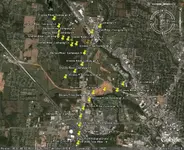
For those who want to search for Civil War relics this may be worth looking into. I had bought a book on "The West Point Atlas of War" The Civil War. I found some of the readings and maps interesting so I thought I would share some of my findings from the Bull Run Campaign 2 and 3 of the positions of Bohnam's, Longstreet's, Early's, Ewell's, D. R. Jones, and Holmes' positions on the First Bull Run Campaign: 2 and 3.
Campaign 2 situation 11:30 am July 21, 1861
Campaign 3 situation 2:00 pm July 21, 1861
Campiagn 4 situation 4:00 pm July 21 1861
Someone in that area may be worth to metal detect for civil war era relics. Below are my Google Earth grid coordinates and who was placed where. You will have to copy and paste onto Google Earth. If I still lived in Virginia I would certainly look into mding there. Maybe worth a try.
Bonham's troop Bull Run Campaign 2, 3, and 4 positions;
38 47' 44.43 N 77 27' 34 W
Longstreet's troop Bull Run Campaign 2, 3, and 4 positions;
38 48' 06.37 N 77 26' 58.21 W
38 48' 08.74 N 77 26' 52.05 W
38 48' 10.72 N 77 26' 44.00 W
Possible Early's Bivouac/Reserves 11;30 am July 21, 1861;
38 47' 46.27 N 77 26' 37.41 W
Ewell's troop positions;
38 46' 44.20 N 77 25' 44.05 W
38 46' 35.57 N 77 25' 20.45 W
38 46' 20.13 N 77 25' 04.68 W
38 46' 57.26 N 77 24' 56.13 W
Possible area or Holmes' Bivouac/Reserves 11:30 am July 21, 1861;
38 45' 34.91 N 77 25' 59.95 W
Possible general area First Bull Run Campaign 2 position of D. R. Jones' troops 11:30 am July 21, 1861;
38 48' 07.72 N 77 25' 06.25 W
In First Bull Run Campaign 3 and 4 positions. D. R. Jones' troops crossed the river and was placed about this area 2:00 pm July 21, 1861;
38 47' 15.65 N 77 26' 10.58 W