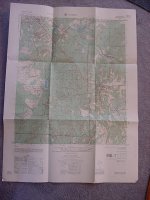
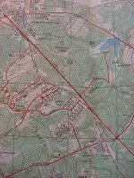
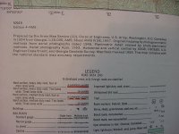
I bought some things at the flea market this weekend, and inside one of the items there was a 1954 Army Corp. of Engineers map of Cusseta, Georgia (Chattahoochee County). It is a topography map, approx. 2' x 3' in size.
I see things on there like:
Railroads, streams, lakes, cemeteries, schools, etc., etc
The map could possibly help you locate some long lost detecting spots?
I really have no need for it, so I would like to send it to someone FREE of charge.
Please reply only if you are in that area and would use it.
First come, first served.
****Please PM me if interested********
Thanks,
MM