DOC NOSS-Victorio Peak OR The Caballo Mountains

whiskeyrat

Hero Member
May 7, 2012
539
1,246
mid Michigan
Primary Interest:
Prospecting
New Mexico 10-24-16 014.jpg
Go that way, its right up there.
 

on the hunt

Full Member
Feb 26, 2014
141
101
Primary Interest:
All Treasure Hunting
Treasminder2 I have to agree with you on the best invention ever brother! By the way I really enjoy reading all your posts and thank you for putting up the link about Dan Fry awesome read. I am a big George Van Tassel fan and haven't heard about Dan until you posted the link and come to find out those's guys where buddy's back in the 50's and done a lot of work together at giant rock back in the day. It's a damn shame they took out Van Tassel before he and the guys got the integratron fired up and running.
 

on the hunt

Full Member
Feb 26, 2014
141
101
Primary Interest:
All Treasure Hunting
LOL Damn good title I know I would be the first one in line to buy the book Treasminder! I haven't heard about the meeting at white sands but don't you know old Eisenhower flipped out when he seen that.
 

nmth

Sr. Member
Oct 11, 2012
251
567
NM/AZ
Detector(s) used
V3(i), ATX, uMax, Gold Bug, TM808, Custom
Here's a picture of the hole and ladder for ya'

I have found old woodworks with mine frames made of 4x4 posts that fell apart like aerogell held together with dried scotch tape, so I myself skipped the adventure...

Boulderhole.JPG

View attachment 1374589 Whiskey
take the camera to this Padre La Rue Vault , go down the wood ladder watch that last rung , it's loose .
go down into the side tunnel that goes up under the Boulder

at 12 feet , you come to a Round Vertical shaft dug like a Well , it goes down 22 feet .

Lower your Vid Camera down the shaft to a foot above bottom

turn it 360 degrees real slow

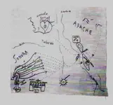
Circled in red , the boulder with the Vault underneath

blue is the shaft ( west side of Boulder )

next is how to find it
 

nmth

Sr. Member
Oct 11, 2012
251
567
NM/AZ
Detector(s) used
V3(i), ATX, uMax, Gold Bug, TM808, Custom
I think that Rog was so focused on the really good stuff way back when that he neglected to take more mundane pictures.

Here's a picture of the green gate at the big boulder where it is convenient enough to just park and walk the rest of the way.

TM2, I wondered about those rocks on rocks; thought they were prospectors' high-grade leavings. Guess my miner's soul is showing...

Modoc is at the end of the road.

!Be safe and don't ruin stuff, people!

JK_at_Green_Gate.JPG

View attachment 1374592
It's an easy walk from where you park to the Vault

as you walk to the vault , you may see small rocks set atop boulders
those were trail markers

opposite side of the Boulder from the shaft , you will find the debris left by the folks who dug it up
3 LB Folgers Coffee cans
Jack Daniels Bottles
old Can food cans .

have fun
but be sure to film the bottom of the shaft .

The pit from surface to doorway into tunnel is 17 ft

12 feet down at an angel through the tunnel to the mouth of the Vertical Shaft

from floor of tunnel to bottom of Vertical Shaft is 22 feet .

The camera must travel at least 21 feet down into the Shaft .

you look for any side opening at the bottom or any Glyphs ( painted or carved )
 

Real of Tayopa

Bronze Member
Sep 4, 2016
1,942
9,101
Mexico
Primary Interest:
All Treasure Hunting
ok Rog. so the lil map has nothing to do with Tayopa, question, why does the name Tayopa appear three times. and it is a looong ways away from Chiapas, part of my old stomping grounds..The dotted lines merely indicate converging trails and the Rio del Norte is a long way away from Chiapas, etc, etc.


undecyphered.jpg
 

Attachments

  • 2.jpg
    2.jpg
    25.9 KB · Views: 125
Last edited:

nmth

Sr. Member
Oct 11, 2012
251
567
NM/AZ
Detector(s) used
V3(i), ATX, uMax, Gold Bug, TM808, Custom
WHERE ?????????!!!!!!!!!!!!!!!!!!

Interesting that you give out so much data and no answer to this yet as far as I can tell by anyone else.

Answer: almost without a doubt, the Shandon Placer or there abouts, though it's not the only place...

I'm still looking elsewhere for the wire gold I've seen samples of - very pretty.

The Shandon area is mostly private land, and people seem to be treating it as a free for all. Making messes, etc. I remember years back when it was a nice quiet place and there were no squatters.

PM for more if you want, but I think you are not a miner. But, there's lots of Gold near or in the Caballos, so local sources for some caches is very feasible.

Good story about a huge P wood log hauled back to town; when hosed down, it yielded a nice little nugget.
 

Real of Tayopa

Bronze Member
Sep 4, 2016
1,942
9,101
Mexico
Primary Interest:
All Treasure Hunting
ok, well lets get at it then. I say that the lil map IS 100% Jesuit. Why did you pick on the 1646 and not the 1861 ? Both of which are important to the Jesuit connection, also why the Bishop's staff - the curved snake looking thing. And the map shows the Gila river, plus it plainly calls the Mt range Caballo and -----

!646 was when Tayopa was in bonanza, and the1861 was the start of the American Civil war, when the Jesuits officially gave up on retrieving the caballo depositories.

That will do for starters/
 

Last edited:

whiskeyrat

Hero Member
May 7, 2012
539
1,246
mid Michigan
Primary Interest:
Prospecting
View attachment 1374592
It's an easy walk from where you park to the Vault

as you walk to the vault , you may see small rocks set atop boulders
those were trail markers

opposite side of the Boulder from the shaft , you will find the debris left by the folks who dug it up
3 LB Folgers Coffee cans
Jack Daniels Bottles
old Can food cans .

have fun
but be sure to film the bottom of the shaft .

The pit from surface to doorway into tunnel is 17 ft

12 feet down at an angel through the tunnel to the mouth of the Vertical Shaft

from floor of tunnel to bottom of Vertical Shaft is 22 feet .

The camera must travel at least 21 feet down into the Shaft .

you look for any side opening at the bottom or any Glyphs ( painted or carved )

My camera is good down to 165 ft
360 degree rotation, full color, waterproof
wr
 

nmth

Sr. Member
Oct 11, 2012
251
567
NM/AZ
Detector(s) used
V3(i), ATX, uMax, Gold Bug, TM808, Custom
that was a Joke post , like i need to chase a placer ,

I thought so, but thought others might be interested. Some of us like minerals (sniff, sniff, boo hoo) and they are easier to hunt down...

There was some Caballos vs Victorio Peak debate going back and forth a while back and I wanted to reinforce that there *is* good gold not only right in Sierra Caballo, but also all around, especially to the West.

Plus, I found the p wood tree nugget story fun, though I did not see it with my own eyes - too many years back.

So, if I am reading this thread correctly lately, you (TM2) think there are NO old stashes in the Caballos or Vic Peak? It's all in the Organs? Maybe I am oversimplifying.

Where does that place the square thing with the cross (or what is it) just north of the range labelled Caballos on the 'Lil map? I was thinking it was Black Mesa past the Fra Cristobals. In your version would it be the Dona Ana's or ?

What about starting an Organ Mountains non-Jesuit Treasure Theory thread to focus the great content that you have been posting lately? I have a few tidbits I may be able to throw in the mix, at least in the geology and pictures from the field department. I'm also interested in the Vic vs Cab part along the lines it has been discussed earlier separately as well.

For the Organs, you all will want to be cognizant of the land status as it is now, and the pending Monument debacle was well - stroke of a pen my $@^!@%. Plus, there's lots of non-human snakes in the field, too, so be double careful.
 

whiskeyrat

Hero Member
May 7, 2012
539
1,246
mid Michigan
Primary Interest:
Prospecting
the original mining districts are currently being "reorganized" in the caballos under the still current mining laws.
When successful, the mining districts will once again make the laws and tell the BLM and FS what to do.
If the Organ Mountains were once again organized into the original mining districts, it may be possible to claim the land back for the miners.
It worked in California, now it is underway in New Mexico.
just something to investigate.
wr
 

Top Member Reactions

Users who are viewing this thread

Top