Dock Hollow, frenchburg Ky.

boomer

Sr. Member
Jul 8, 2003
487
523
kentucky
Detector(s) used
army all terrain
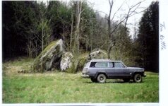
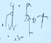
I have received several PM's on how to find sites from some of the Spanish/French maps that have been put up. first, always remember that the Spanish always had store houses. to keep the kings goodies safe. it doesn't matter if they where working for the crown are they were working for them self's. sometimes mines would be booby trapped with hidden rock falls or powder pored of the floor of the mine shaft. think and look close to your surrounding's. The French were more easy going and did not have the strict code the Spanish had. I get the feeling the priest/monks took care of the codes and how they were used on carvings and rock sculpture's. so far it seems the Spanish/French always had their store houses near by. I know some of the areal photo and topo maps are not detailed enough, so I thought I would give more detailed info on locations. this first one is 3 miles southeast of frenchburg ky between dock hollow and rt. 460 and the park above dock hollow. at the end of Clifton creek is the large rock known as tea kettle looks like a handle and spout, at one time their were carvings all over it. lucky I made drawings of those. below is photo of same and one part of one of the carvings. later this week I will put the location of where hopefully something is still buried.
 

Attachments

  • tea kettle.jpg
    tea kettle.jpg
    165.5 KB · Views: 277
  • tea kettle 1 maps.jpg
    tea kettle 1 maps.jpg
    26.1 KB · Views: 451

KY Hiker

Bronze Member
Oct 28, 2014
1,537
3,220
North Central Kentucky
Detector(s) used
Whites
Primary Interest:
All Treasure Hunting
Last edited:
OP
OP
boomer

boomer

Sr. Member
Jul 8, 2003
487
523
kentucky
Detector(s) used
army all terrain
HIKER: yes indian creek is one of the main indian trails going north from the crossroads at McKee ky. east to war fork up to battyville than past natural bridge state park. than across the red river to indian creek than up same, cross over 460 to wynn branch, up cliffton creek, to beaver creek. wynn branch is interesting, along the face of the hill/cliff at the end facing west there are places that looked to be dug, also a rock that was carved, not sure if it was the face of a bear or mountain lion. also next to it is a flat rock with vary faint lines on it. I could make out a flipe or fllape, like the one carved on caney creek on the little sandy river in Elliott county. the tea kettle rock
is at the mouth of wynn branch and Clifton creek on the east side. I hope to have the waybills set up on how to find the buried stuff and the mines by sunday. I know the mines are still there. the big IF is, are the buried stuff is still there.
 

KY Hiker

Bronze Member
Oct 28, 2014
1,537
3,220
North Central Kentucky
Detector(s) used
Whites
Primary Interest:
All Treasure Hunting
I can't wait to read it!
I thought there was discussion of Beaver Creek possibly matching one of the maps in a thread on here? Maybe it was about the tea kettle rock... I can't remember.
 

Top Member Reactions

Users who are viewing this thread

Top