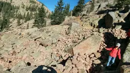
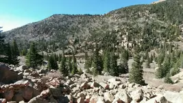
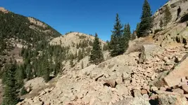
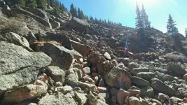
Found some hand stacked rocks way back in the woods.

diggingthe1

Silver Member
Joined
Feb 11, 2015
Messages
2,697
Reaction score
6,534
Golden Thread
0
Location
Victor, CO...City of Mines
Detector(s) used
Minelab EQ800, Ex2
Primary Interest:
All Treasure Hunting
img20161211_061639.webpimg20161211_061904.webpimg20161211_062005.webpimg20161211_032848.webp
Took a huge hike down a remote Colorado Mt. About 3 hours down my boys eyeball these strange formations. Barely visible from the bushwack trail. I was reading some old gold forums about old timers hand stacking rocks afterward and it made sense.
We will do the hike again, very remote. Hopefully we can spend some time and get down to some undisturbed bedrock. How would you go about mining this area? Haul buckets to the stream about one half mile away, or drywash? I mainly just wanted to share my story, and get some ideas. Its an insane hike, I don't want to pack too much in unless its worth it!!! Hope you are 'll finding color:)
 

Upvote 0
View attachment 1390306View attachment 1390307View attachment 1390309View attachment 1390328
Took a huge hike down a remote Colorado Mt. About 3 hours down my boys eyeball these strange formations. Barely visible from the bushwack trail. I was reading some old gold forums about old timers hand stacking rocks afterward and it made sense.
We will do the hike again, very remote. Hopefully we can spend some time and get down to some undisturbed bedrock. How would you go about mining this area? Haul buckets to the stream about one half mile away, or drywash? I mainly just wanted to share my story, and get some ideas. Its an insane hike, I don't want to pack too much in unless its worth it!!! Hope you are 'll finding color:)

It looks to me like there are hand stacked rock in the top center photo (lower left corner) and lower left photo (center). They appear to be photos of the same rocks from different angles.
Mike
 

Interesting pictures, any chance those little walls could be to hide someone? Defense or hunting? Just a guess. Beautiful country over there!
 

Interesting pictures, any chance those little walls could be to hide someone? Defense or hunting? Just a guess. Beautiful country over there!
or shelter
 

The most important thing is you HAVE to make sure it's not claimed! Claim jumping can get you in deep trouble. Claim owners rely on those stones for a living and don't take kind to people stealing them. I believe they also have a set season to mine for gems, so that could get you in trouble also. Please don't take this lightly.
 

The area is not claimed from what I can tell on Colorado land matters website. I thought they were ancient shelters which is why I followed my boys up there. It wouldn't make any sense, someone was looking for something. The area has not been disturbed fir a while. It will be exciting to find out what. I was looking for something to tell me from the rocks around but didn't see anything at the time. It is about 50 feet x 50 feet. They couldn't move the big rocks. The rocks on the left told me bedrock was close so I assumed gold. I appreciate all the responses. The area was in the vicinity of Pike's Peak. Do most telluride minerals look the same like in the Cripple Creek district?
 

Well, since you are in the Pikes Peak region, I would think the tellurides you find would look like those. There are samples in the Cripple Creek Mining Museum. I have to admit, having seen a fair amount of telluride ores from Cripple Creek, they don't all look alike or even like ore--but they are dense (heavy). Some have flecks of gold you can see but not most that I have seen.

If grass has grown up in the stacked material, at that altitude, it is old. Please keep us posted, though other than research, there is not you can do until about end of May, early June. At least today it looks like we may hit 40 degrees; nice after the extremely cold weather last week here in Colorado.
 

Thanks Dave, I have looked those Samples very well. I'll have to bump this thread up in the spring and show off all the goodies. We are planning a trip in the fall when the leaves are turning:) Thanks again everybody for the wonderful knowledge. You gold hunters know the true meaning of work:) Happy Hunting
 

First off you have to do your due diligence and make sure you're good to go on that. This means going to the county recorders office and looking at the records for that area. You can also see if there have been any claims there in the past and possibly what they were mining. Then I'd do an exploratory trip with gear to do either dry panning or a small puffer drywasher. There is no need to haul anything big in till you've proven that there is something/enough there to make it worth the effort.
 

Looks like typical breakdown at timberline.(Freeze/thaw) You could poke around for a pocket. Check for claim markers. (posts)
Pegmatite is nice. It looks like 11000' or higher from the trees. Altitude makes me tired.
 

Is that in the Catamount area?

Taken from: History and Mysteries of Catamount Ranch Open Space
By: Kim Carsell and Kim Long
Teller County Division of Parks

"An interesting story that may explain the presence of the many scattered glory holes around the Catamount area was printed in the Gazette Telegraph on July 11, 1948. It was regarding a lost mine on Catamount Creek. The article states that there was an old miner who struck a vein of gold somewhere along the South Fork of the Catamount Creek in 1905 or 1906. He traveled through Green Mountain Falls with his three burros on his way to the Golden Cycle Mill in Colorado Springs. Rumors were that the old man carried ore “richer than anything that was ever found in Cripple Creek.” Many speculated that the mines location was somewhere along the South Fork of the Catamount Creek, but others claimed he had no mine at all and was actually carrying high-grade ore down from the Cripple Creek area. Enough people believed it to be near the Catamount area, that multiple prospector holes were dug all around the area. CROS also contains its fair share of prospector holes that may have been spurred on by one such miner. On his last trip to Colorado Springs, he was admitted to the hospital for tuberculosis. While on his ”death bed,” he was asked to reveal the location of his mine, but he refused saying, “let them find it the way I found it. But it will be hard to do. I have planted trees on the dump” (Dudley, 1948)."
 

Look for trash around the area if old timers were there they left trash. They would not carry it out. You maybe able to tell what time the work was done.
 

Is that in the Catamount area?

Taken from: History and Mysteries of Catamount Ranch Open Space
By: Kim Carsell and Kim Long
Teller County Division of Parks

Thanks for the story, I have not heard that one. It is not quite in that area, but you never know. I will have to keep my eyes open in that area. There is also a tale of a wealthy miner that no one could ever follow leaving Victor and returning with high grade. Thanks for the post.
 

Look for trash around the area if old timers were there they left trash. They would not carry it out. You maybe able to tell what time the work was done.

The local historical society will be able to date the site by the type of tin cans left behind.
 

Was at this spot a few times through the years , In our opinion these walls were built by the Utes , probably for vision quest or harvesting eagle feathers , doubt very seriously it was for defense due to its location. We didn't see anything that suggested mining or gem hunting at this spot . Good luck in the hunt !
 

On the miner who would disappear on the peak ,,,, I believe I found his shaft complete with squared timbers stacked under a tree and his lunch box sitting on top of them, his cabin , and stock corral , we found a small pile of bottles out the front door. I have not been to it for years,since my last heart attack, want to make a try for it this year , the shaft is about 30 feet deep and has a drift going off to the north we never had any rope so have not been down it. It will be a great site for detecting and checking out that shaft . If my heart won't let me get return, bug me some and I'll turn you on to it and some other sites up there
 

Thanks for the posts Charlie, Ill pick your brain this spring before we head back there. We would love the company. All the rocks were moved out which sure makes me think mining... but my first hunch was Native American. Definatly worth the adventure especially for the boys sake:) Your spot about the disappearing miner sure is intriguing. That would be hard to do alone.
 

On the east side of Pikes Peak, I have found mine shafts off of a road so old its barely existent that heads down next to a creek called Sweet Water Creek that eventually feeds into South Cheyenne Creek. You get to it from Gold Camp road that is blocked off that eventually merges onto Old Stage Road when it turns into High Gold Camp Road headed to Cripple Creek. If you go to far down, you end up at private property, but one of them I have not ventured in, because its been covered up partially, and the other probably goes in about 20 meters.

Has anyone found any interesting Ute artifacts or ruins on or around Pikes Peak, I have found some old Ute forts at Red Rocks Open Space, and some Prayer Trees on Manitou Mountain.

There were some spots around Lake Lorraine that I have read about. I can't remember what book. I'm sure they camped or hunted around most lakes. There are artifacts found all over the peak, dating long before the Utes. I'm sure it has been a destination place forever. The sun first touches this peak:) Its a great mountain to explorer. You should start a thread in native American forum about pikes peak. I bet we would both learn a lot.
 

Last edited:
There were some spots around Lake Lorraine that I have read about. I can't remember what book. I'm sure they camped or hunted around most lakes. There are artifacts found all over the peak, dating long before the Utes. I'm sure it has been a destination place forever. The sun first touches this peak:) Its a great mountain to explorer. You should start a thread in native American forum about pikes peak. I bet we would both learn a lot.

Awesome, thanks for the quick reply, I actually bushwhacked on the east side at 10k FT for most of last winter, a humbling experience to say the least. Ive gone into a in depth study of the Utes and went through the historical records at the library and have been surprised why there are not archeological sites on the Pikes Peak shelf, you have them all around, Colorado Springs, Rampart Range, Cripple Creek, Muller State Park (to name a few) but yet so far no evidence of any investigation on Pikes Peak itself. I even went to the local schools here in Colorado Springs and their guess is ether lack of funding or bureaucracy with the National Forest Service. Whatever the reason may be, I have yet to even find a statement that any type of investigation has been done so far. Pikes Peak is a center piece of the highest importance for the Utes so I am is curious. With that said, that does leave room for cultural discoveries :).
 

Also, did you mean Lake Moraine where early homesteaders settled before they were kicked out by the forest service later? If im incorrect, could you point me in the right direction of Lake Lorraine? Thank you.
 

Top Member Reactions

Users who are viewing this thread

Back
Top Bottom