Welcome to Treasurenet !!
Can't help you with its value but I can tell you that his address in 1922 was 109 North Market Street in Chicago.
Source: 1922 American Book Trade Manual.
Don.......
While you wait for other responses, you may wish to contact the Library of Congress Map Department using this form: https://ask.loc.gov/map-geography
Don.....
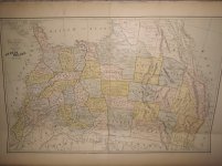
George F. Cram was in partnership with Rufus Blanchard from 1867 but Cram took full control of the business in 1869, at which time he renamed it as the “George F. Cram” company.
Lots of other dating clues such as: the “Dominion of Canada” didn’t exist under that name until 1867, and the “Indian Territory” shown had already been eroded by 1890 before it ceased to exist in 1907 when it was annexed to become Oklahoma. More specifically, Dakota is shown as a single territory (ie pre-1899) with borders consistent with post-1869, but missing the small Niobrara River area that was transferred to Nebraska in 1882.
So, you could put it somewhere between 1869 and 1881. These kinds of maps had large print runs and, without any special interest such as railroads or whatever, I doubt that it would fetch more than about $15.
So, you could put it somewhere between 1869 and 1881. These kinds of maps had large print runs and, without any special interest such as railroads or whatever, I doubt that it would fetch more than about $15.
Sorry... correction to what I said there. I had that the wrong way round. Since the Niobrara River region is shown in Nebraska not in Dakota, the map must be 1882 or later.
And since there's no Oklahoma, it can't be later than 1907 and more probably not later than the 1890s.