PatrickD
Hero Member
- #1
Thread Owner
Hi Everyone,
I posted this information in the Maps forum but thought it made more sense to be put here in the state area.
Here is a link to historic Texas maps. They are Sanborn insurance maps and date back to the 1800s.
Sanborn Maps of Texas - Perry-Castañeda Map Collection - UT Library Online
Many of the maps have detail identifying the original location of buildings and what businesses were there. This has helped me doing local research.
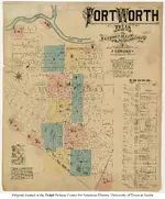
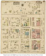
Here are two examples from the Fort Worth maps. These are from 1885. One is the total area mapped (being the original downtown area) and the next one is a segment with more detail.
 -
- 
I hope this helps you with your research.
Happy Hunting.
Patrick
I posted this information in the Maps forum but thought it made more sense to be put here in the state area.
Here is a link to historic Texas maps. They are Sanborn insurance maps and date back to the 1800s.
Sanborn Maps of Texas - Perry-Castañeda Map Collection - UT Library Online
Many of the maps have detail identifying the original location of buildings and what businesses were there. This has helped me doing local research.
Here are two examples from the Fort Worth maps. These are from 1885. One is the total area mapped (being the original downtown area) and the next one is a segment with more detail.
 -
- 
I hope this helps you with your research.
Happy Hunting.
Patrick


