How deep???

Tony_agr

Jr. Member
Joined
Jun 1, 2014
Messages
83
Reaction score
55
Golden Thread
0
Location
Placerville
Detector(s) used
Fisher Gold Bug
Falcon MD20
Primary Interest:
Prospecting
Frustration is setting in.. I live in an area that historically produced 100's of thousand of onces, at least according to western mining history web page
I cleared tons of Blackberry bushes to access this creek that no one has worked for at least 100 years, there is quartz everywhere, no large boulders but all of the indicators are there.. my issue is this how deep do I have to dig before I should find some pannable or sluicable gold?? I have run a lot of dirt,clay,gravel etc and have found some small flake, I have tried to dig to bedrock but never have hit is as it seems that the bedrock is nothing but slate on its side.. unfortunately my creek access is right on the downstream side of a 2' culvert and there is a pond above that..its making me crazy, should I try and bust up the slate??? or Just keep going at the clay which is 8-12" down?.. seriously I'm right in the heart of Placerville gold mining.. I know its here.. but where???? can a small creek not have "normal" bedrock??
 

Upvote 0
You mean the bedrock in place is on its side like books stacked together. That's great bedrock if your on it just open up more surface area and see if you can find where the creek has flowed at other times. Aldo look for evidence of rock stacks and old diggingd. That would be close to where the creek was when that came across it back in the day if it was worked. The only reason not to go strait to bed rock is if you know for sure there are flood layers. That pond and culvert means only the finest gold is being moved into your creek. Any bigger gold is gonna be deeper. What area or state are you in. You can pm me if you don't want to broadcast it
 

He said he was in placerville.

Also any large gold is either going to be deep or above the pond.
Do try and find the old creek bed and see if you can determine where it has meandered.
Regarding the vertical shale layers..... split those babies, they can act like natural riffles and sometimes you can find a nice little bunch of gold in between them...
It may be pretty fine gold but it all adds up.

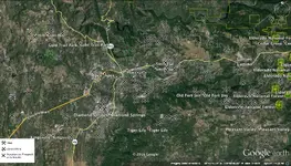
Here are some historic mine sites ..... you can get this info from the USGS maps online.

Placervile.webp
 

Last edited:
I'll just add this; even though you are located in a historically rich mining town there is no guarantee that every small creek bed, wash, drainage has substantial amounts of gold. If you're not getting good results after testing several spots at bedrock level in your creek I would consider prospecting elsewhere - there is a reason they call it prospecting and not finding. Also, quartz is incredibly common and it's presence isn't a guarantee of the presence of gold either. :2barsgold:
 

Last edited:
I would bust up the slate with a big digging bar then clean it up with a whisk broom -- then test pan it.
I've done this good success.
Good luck
Mike
 

I have a claim north of placerville, I have found at this location gold is only found on or better yet in the bedrock. Same slate as you describe, and I haven't found a single spec in any of the gravels or material otherwise. Drove me crazy for the first year as I'm use to at least color in the gravels I'm normally digging. I've found to look for decomposing slate and breaking it up and panning that and this has led to good results, still not as rich as I hoped but the gold found is usually chunkie. I've found that the creeks and small drainages produce much different than major tributaries nearby where flood gold is common. The flow is much less and the gold moves down twards bedrock rather than downstream more so and is more than likely a lot closer to the source given the circumstances. A lot of the creek beds around gold country were worked hard by the old timers if they had decent gold, so usualy working higher deposits is the way to go. Hope this helps, find some bedrock and you might see better results.
 

If the creek doesn't get 20 feet high in the flood years to move the gold, then the 2ft culverts shows there's not enough flow.
 

Agree with Reed.
PLACER gold is moved and deposited by LARGE hydraulic movement over 1000's and 1000's of years.
(You may not see it now by the way.) That's why I always start with a TERRAIN map and look for areas
that could have had strong water many many years ago. Simple terms.... Look for the "V" in the area.
That low point where an old river flowed.
Example.... There is a corn field near us and you'd never think water flowed through there.
But if you step back and look at the terrain you'll see it's the perfect deep "V" or valley surrounded by hills.
Sure enough, when they till it old large, round, quartz, river rocks come up. It hits the creek where we dredge and it was the
richest ground on the property. There's probably close to a million dollars worth of gold under the field.
So.... look around and think WAY WAY back. Where did the BIG water flows move through the area.
Doc
 

With a lake above where your at you won't be getting any gold traveling down the creek it will stop at the lake, should be gold there from before the lake if your in an area known for gold though.
 

That pond could also only be twenty years old. That usgs map is not very accurate. A lot of its locations are off duplicate and incomplete. mylandmatters is much more useful. The historic claims layer will tell you a whole lot more.
west of 49 is mainly slate and quartz. the cool thing about Pville is you have tertiary influence and a lot of hardrock activity. east out Newtown towards Camino and Pleasant valley there are old gravel channels. they remain in the ridge between town and pleasant Valley road Its the anchient American, Weber cuts it. There was a lot of drifting done Smith Flat. The whole back side of that ridge the south side was hydraulic mined. They never found bedrock south og texas hill in several areas. I lived on cedar ravine. If you drive around back there the road cuts will show you different areas and gravels in place. There were many ricj pay layers even though they werent on bedrock. There is an andesite cap in the area. Thats where Lava Cap winery got its name. I missed that your sidebar said you were in Placerville. One thing about the area around town is that there is very little accesable public lands. mostly private. EVERY drainage has gold.
 

There are many places the numerous waves of miners in the past 160+ years have scoured that area repeatedly repeatedly. Gold miners make the bedrock is a fact in that creek. Marty had a factory on the south end of town for many years and only gold I found was in that righteous flakey black shale type materials. Specks don't float my boat so after numerous samplings said no to anymore time wasted. Lots of luck as some of most RIGHTEOUS poundage streaks have been in spots many folks have said were pounded to death. Just have a ball and enjoy and all else will flow-John
 

There are many places the numerous waves of miners in the past 160+ years have scoured that area repeatedly repeatedly. Gold miners make the bedrock is a fact in that creek. Marty had a factory on the south end of town for many years and only gold I found was in that righteous flakey black shale type materials. Specks don't float my boat so after numerous samplings said no to anymore time wasted. Lots of luck as some of most RIGHTEOUS poundage streaks have been in spots many folks have said were pounded to death. Just have a ball and enjoy and all else will flow-John

I don't know how many times I've worked spots others said were hammered to death or that the Old-timers got it all; I love to take home the gold that's left there . . .

All the best,

Lanny
 

Top Member Reactions

Users who are viewing this thread

Latest Discussions

Back
Top Bottom