Ragnor
Sr. Member
- Joined
- Dec 7, 2015
- Messages
- 445
- Reaction score
- 423
- Golden Thread
- 0
- Primary Interest:
- All Treasure Hunting
I have been evaluating a certain area and after much study I arrived at a rather interesting conclusion. The short version is that the area I am prospecting. A steep, mountainous canyon. Used to be an ancient inland sea or lake. This is supported by the fact that I found a fossilized dolphin bone in a boil hole in the creek at the bottom of the canyon and the following images.
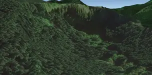
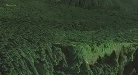
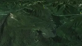
This is the basic Google Earth image, nothing too impressive. The original question haunting me, why is there a flat spot when everything else is mountains? But a couple days ago I noticed the ancient waterfall front and center in the image. "What the hell is that doing there"?, I asked myself.
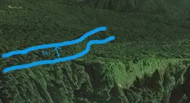
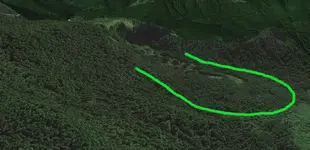
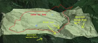
I was also working on looking for high benches, so I created an overlay for the area of interest. Now I noticed a "bench" running the entire perimeter of the flattened area at about the same elevation, with the exception of a massive missing section where the current stream bed is. The "bench" height coincided not only with the ancient waterfall I had observed, but also with the strange ancient river course through the woods along the road that accesses this area on the right. That old stream bed in the mountains has always intrigued me. Now I can see that it used to be the drainage for this ancient lake.
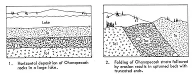
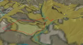
This also coincides with the geological map of the area to some extent.
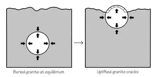
Now the part I don't know is: Does this help me at all with finding any super enriched gold deposits? I do not believe the gold was exposed until the violent uplift of the ridge which split the valley. I hypothesize that the force of this uplift created the hydraulic pressure that created first the waterfall and then blew out the entire canyon wall and drained the lake/sea. Without getting too far into it this event would coincide with the massive destructive event approximately 45 million years ago 'geologic time' (12000 yrs. bible time). So I'm not sure that the lake actually existed in the time that the gold has been exposed to weathering.
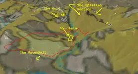
My observations coincide with 1977 evaluation of this mining district as to the descriptions given of the ore bodies and the alteration state of the vein emplacement and heavily altered host rocks. Showing both hydrothermal emplacement and high temperature alteration of the original material.
I figured I'd post it up and see what folks had to say about it all.
Please feel free to share you thoughts on this. Wisdom is found in a multitude of counselors.
This is the basic Google Earth image, nothing too impressive. The original question haunting me, why is there a flat spot when everything else is mountains? But a couple days ago I noticed the ancient waterfall front and center in the image. "What the hell is that doing there"?, I asked myself.

I was also working on looking for high benches, so I created an overlay for the area of interest. Now I noticed a "bench" running the entire perimeter of the flattened area at about the same elevation, with the exception of a massive missing section where the current stream bed is. The "bench" height coincided not only with the ancient waterfall I had observed, but also with the strange ancient river course through the woods along the road that accesses this area on the right. That old stream bed in the mountains has always intrigued me. Now I can see that it used to be the drainage for this ancient lake.

This also coincides with the geological map of the area to some extent.

Now the part I don't know is: Does this help me at all with finding any super enriched gold deposits? I do not believe the gold was exposed until the violent uplift of the ridge which split the valley. I hypothesize that the force of this uplift created the hydraulic pressure that created first the waterfall and then blew out the entire canyon wall and drained the lake/sea. Without getting too far into it this event would coincide with the massive destructive event approximately 45 million years ago 'geologic time' (12000 yrs. bible time). So I'm not sure that the lake actually existed in the time that the gold has been exposed to weathering.

My observations coincide with 1977 evaluation of this mining district as to the descriptions given of the ore bodies and the alteration state of the vein emplacement and heavily altered host rocks. Showing both hydrothermal emplacement and high temperature alteration of the original material.
I figured I'd post it up and see what folks had to say about it all.
Please feel free to share you thoughts on this. Wisdom is found in a multitude of counselors.
Amazon Forum Fav 👍
Last edited:
Upvote
0


