whiskeyrat
Hero Member
- Joined
- May 7, 2012
- Messages
- 539
- Reaction score
- 1,248
- Golden Thread
- 0
- Location
- mid Michigan
- Primary Interest:
- Prospecting
- #1
Thread Owner
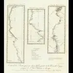
I purchased a cd of old New Mexico Maps.
Its interesting to see how the mountain ranges names moved around from the period of 1800 to 1877.
Kinda seems like if your reading a treasure tale that happened in lets say 1863, and mentions the caballo mountains, you might have to reference a map from 1863 to make sure where the "caballo" mountains were at that time.
The major ranges seem to move around.
Anyway, attached is the maps of 1807 showing the "countries" in northern Mexico and the route and existing villages etc up the Rio Grande to Santa Fe.
Hopefully these will show up and be "seeable"? have not tried this before.
hmmm, seems to be too large its 6.5 mb as a pdf
enjoy
wr


 ?
?

