Is the Pit Mine really the Lost Dutchman mine?

wrmickel1

Bronze Member
Nov 7, 2011
1,854
1,392
Jamestown ND
Detector(s) used
Garrett 2500
Primary Interest:
Other
I did watch that a few days ago but the only thing I came away with from what Ron said is that he has no doubt that the Kochera Ore came from the east side of the mountains and was found out in the Malapais area because the Spanish lost the saddlebag at some point on a trip out of the mountains. I guess one can read between the lines and it's not a great stretch to believe that he's saying it came out of the Silver Chief mine but he doesn't exactly come out and say that.

Joe has been saying the Kochera Ore came out of the Silver Chief for more than a few years, but unless I'm mistaken his belief is very different from what Ron is saying. Joe - correct me if I'm wrong, but you believe that the Ore Ron possesses as "Kochera Ore" came directly out of the Pit Mine and was never found out on Malapais.

Those are 2 different things. Maybe I've been wrong about what Joe has suggested - hopefully he can correct me.

One other thing - does anyone else find it a little odd that Ron would suggest that the best way for the Spanish to leave the mountains from the Roger's Trough area would be to go out through the mountains to the N/NW all the way to the Salt River? I suppose if they were transporting the ore down the Salt River or processing it along the river that may make sense, but to just get out of the mountains and head back to Mexico doesn't it seem like it would be easier to just head south directly out of the mountains?

Must agree with you Cubfan,

No one alive could say which way those donkeys were heading, North South East or West. But there's a few more holes in his story then that, A 75 % chance isn't the best! Now I'll give him his dues, He's a ledgen and the first person I headed for about Ten years ago.

But I'll say his theory is about a 0% chance the mine is the Dutchman's

To many holes in it

babymick1
 

Cubfan64

Silver Member
Feb 13, 2006
2,986
2,790
New Hampshire - USA
Detector(s) used
Fisher CZ21, Teknetics T2 & Minelab Sovereign GT
Primary Interest:
All Treasure Hunting
Paul,

Hope you are staying warm and dreaming of warmer climes.
After dealing with a blizzard today with a foot or more of snow and much higher drifts due to high winds, you know it!! Wife and I have been having serious conversations about the need to put together a plan this year on how and when we can move to an area with little or no snow. My bones ache from today's shoveling!!!
 

markmar

Silver Member
Oct 17, 2012
4,120
6,262
Primary Interest:
All Treasure Hunting
Marius,

Ron has been all over the Superstitions. Not many, still living, who can make that claim......but they are out there. What about you?

Good luck,

Joe

Joe

They are out there like other thousand who were there . I can't see the difference they did in regards the LDM . Just unproven theories and assumptions .

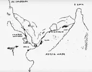
So , you believe everywhere the Perfil map fits , there is a human head profile of stone above a tunnel ? Please answer to this question and leave out what do anyone in those mountains .
 

Last edited:

wrmickel1

Bronze Member
Nov 7, 2011
1,854
1,392
Jamestown ND
Detector(s) used
Garrett 2500
Primary Interest:
Other
Markmar

There's faces in any environment around the world ��
Dogs too ect. It's the brain itself that does this, Facial recognition phenomenon inspired software based
programs in the dawn of the computer age.

Now with that, you should be able to determine weather its man made or just a Out cropping of nature.

good luck, Stay safe and good hunting

babymick1
 

markmar

Silver Member
Oct 17, 2012
4,120
6,262
Primary Interest:
All Treasure Hunting
Markmar

There's faces in any environment around the world ��
Dogs too ect. It's the brain itself that does this, Facial recognition phenomenon inspired software based
programs in the dawn of the computer age.

Now with that, you should be able to determine weather its man made or just a Out cropping of nature.

good luck, Stay safe and good hunting

babymick1

Mickel

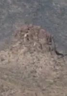
I believe if the profile ( Little man clue ) would been man made , maybe would be more perfect or closer to human face characteristics .
Like you will see in the picture below , the profile was made by the mother Nature and is situated just above the horse head . Look at the profile in the picture and compare it with the profile in the map . I believe the match is about 100% .

Profile.jpg perfil mapa.jpg
 

wrmickel1

Bronze Member
Nov 7, 2011
1,854
1,392
Jamestown ND
Detector(s) used
Garrett 2500
Primary Interest:
Other
Mickel

I believe if the profile ( Little man clue ) would been man made , maybe would be more perfect or closer to human face characteristics .
Like you will see in the picture below , the profile was made by the mother Nature and is situated just above the horse head . Look at the profile in the picture and compare it with the profile in the map . I believe the match is about 100% .

View attachment 1534083 View attachment 1534084


Your image is so small and of poor black and white I'm not sure but
I'm thinking that this boots on the ground pic might help you.


IMG_1657.JPG

It does seam be the same pic,

babymick1
 

wrmickel1

Bronze Member
Nov 7, 2011
1,854
1,392
Jamestown ND
Detector(s) used
Garrett 2500
Primary Interest:
Other
Markmar

Here I'll help you out, Go to google earth and download the Mobile App or computer version which ever works for you.
Don't use other such apps. Google earth only! Now thousands of hikers use this sight and post hundreds of pic's all throughout the superstitions. Hit the blue squares to look at there pics. It puts you in there from your Chair. That The beauty of that app.

babymick1
 

OP
OP
Oroblanco

Oroblanco

Gold Member
Jan 21, 2005
7,838
9,830
DAKOTA TERRITORY
Detector(s) used
Tesoro Lobo Supertraq, (95%) Garrett Scorpion (5%)
Markmar

Here I'll help you out, Go to google earth and download the Mobile App or computer version which ever works for you.
Don't use other such apps. Google earth only! Now thousands of hikers use this sight and post hundreds of pic's all throughout the superstitions. Hit the blue squares to look at there pics. It puts you in there from your Chair. That The beauty of that app.

babymick1

I have to respectfully disagree in part. While your advice is perfectly sound, just a personal opinion but I like Virtual Ocean better than Google Earth. It has a little bit more functions, like being able to swap between the satellite imagery and the USGS topo maps, Google Earth can't do. But I basically agree, stick with the one you are familiar with.

Please do continue,
:coffee2::coffee2:
 

OP
OP
Oroblanco

Oroblanco

Gold Member
Jan 21, 2005
7,838
9,830
DAKOTA TERRITORY
Detector(s) used
Tesoro Lobo Supertraq, (95%) Garrett Scorpion (5%)
I don't know, never looked, as I don't trust hikers pictures to be accurate. It might not.
 

markmar

Silver Member
Oct 17, 2012
4,120
6,262
Primary Interest:
All Treasure Hunting
You have to know , how in the Perfil map , the rock " human " profile is not where the map shows in regards with the cave and tunnel , and the trick is in the word " ESCARCADIA " . Your mistake of this word translation , is because you used modern Spanish , separating some letters to make two or three words that could make sense .
 

coazon de oro

Bronze Member
May 7, 2010
1,625
3,863
texas
Primary Interest:
All Treasure Hunting
Mick,

This photo, said to be taken from Bull Pass by Doc Rosecrans:


It was sent to me this morning by a friend.

Good luck,

Joe

Howdy Joe,

It's clearly not the right profile. Many believe that the profile map fits in different places, but this is not so. It fits in one place only, that is the beauty of a profile map, if it was captured at the spot. If it was done by memory, it may be a little harder to find. I have never tried to find that spot because I have never been in those mountains. This can not be done with g.e., but if you know where Weaver's Needle is, the South Summit, Four Peaks, and a Cavern with a house in that area, it should be easy to find.

That profile is seen from the South looking North, with Weaver's Needle to the left. It has "la cima mas alta en medio" the highest summit in the middle. That is Four Peaks in the far North, seen between what looks like a head, and the South summit.

Homar
 

azdave35

Silver Member
Dec 19, 2008
3,606
8,104
"but if you know where Weaver's Needle is, the South Summit, Four Peaks, and a Cavern with a house in that area, it should be easy to find."

homar..there isnt anything in those mountains that is easy to find
 

coazon de oro

Bronze Member
May 7, 2010
1,625
3,863
texas
Primary Interest:
All Treasure Hunting
"but if you know where Weaver's Needle is, the South Summit, Four Peaks, and a Cavern with a house in that area, it should be easy to find."

homar..there isnt anything in those mountains that is easy to find

Howdy Dave,

More so when some don't even know what to look for, that's why I'm trying to help some understand the map, and what they should be looking for in the picture. If Four Peaks is not visible to the far North, between the rock head, and South summit, they are no where near the right spot. Once you have it in order with W.N. to your left, the rest should not be hard to find. It could also be more likely that it is a fake map.

Homar
 

azdave35

Silver Member
Dec 19, 2008
3,606
8,104
Howdy Dave,

More so when some don't even know what to look for, that's why I'm trying to help some understand the map, and what they should be looking for in the picture. If Four Peaks is not visible to the far North, between the rock head, and South summit, they are no where near the right spot. Once you have it in order with W.N. to your left, the rest should not be hard to find. It could also be more likely that it is a fake map.

Homar
homar....maps and being able to understand them hasn't helped anyone find the mine in 125 years...the area is just too rough ...all the maps in the world isn't going to change that
 

cactusjumper

Gold Member
Dec 10, 2005
7,754
5,389
Arizona
homar....maps and being able to understand them hasn't helped anyone find the mine in 125 years...the area is just too rough ...all the maps in the world isn't going to change that

Hi Dave,

Is it your opinion that the person who found and showed the Pit Mine to our friends found it by accident? Do you know who that person is?

Take care friend,

Joe
 

azdave35

Silver Member
Dec 19, 2008
3,606
8,104
Hi Dave,

Is it your opinion that the person who found and showed the Pit Mine to our friends found it by accident? Do you know who that person is?

Take care friend,

Joe
joe...i'm not sure if they found it by accident or was taken to it...i'm pretty sure i know who you are talking about
 

somehiker

Silver Member
May 1, 2007
4,365
6,426
Primary Interest:
All Treasure Hunting
So why does this shadow person not step forward, or at least allow his friends to share his name ?
There must be a good reason, since a few at least, believe he alone solved the great mystery of the Lost Dutchman Mine.
Perhaps he missed that golden opportunity, in the showing of his discovery to the others, and was no longer able to tell his story.
Was he threatened or worse ? Could it be that there really IS a lot more to the saga of the Silver Chief, that if made public, would place other lives in jeopardy ?
It's been said that one of those he shared his discovery with, eventually organized a group to open that mine and to divide what they found amongst themselves.
Did the shadow person receive a share as well ?
Or was he betrayed ?
Gassler ?...... Shade ?......or maybe even Gassler AND ultimately Shade as well.
 

Last edited:

Top Member Reactions

Users who are viewing this thread

Top