Last chance on the hotspot... Saxon Brooch - UPDATED - GPS-ing

CRUSADER

Gold Member
May 25, 2007
40,890
45,653
ENGLAND
🥇 Banner finds
27
🏆 Honorable Mentions:
1
Detector(s) used
XP Deus II v0.6 with 11" Coil
Primary Interest:
All Treasure Hunting
We had our last chance on the new land hotspot tonight before the crop shows. 2 hours trying to find the extent of the roman area.

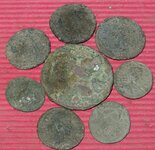
Got 8 roman coins (4 each), which takes us over our 300 target to 306 :thumbsup:

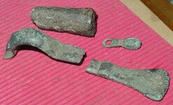
More importantly we shared finding our FIRST ever Anglo-Saxon Brooch. Small-long brooch dating to the 6th century :o I found the bottom piece & shortly after Dad got the middle piece. The top square headed piece is still out there to find. There is remains of the iron pin in the catchplate which indicates it was in the locked position. I'm going to speculate & say that it was a burial good, as it did come off a slight mound. We have GPSed all finds & of course we will be back to find the limits of the site & hopefully the rest of the brooch.

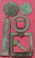
WHAT A GREAT FIELD - Celtic, Roman, Saxon, Medieval
 

Attachments

  • 1.JPG
    1.JPG
    64.7 KB · Views: 990
  • 2.JPG
    2.JPG
    113.1 KB · Views: 983
  • 3.JPG
    3.JPG
    101.6 KB · Views: 978
Upvote 0

shaun7

Gold Member
May 20, 2008
6,193
64
uk
Detector(s) used
tesoro eldorado, tesoro lobo,goldmaxx xp
Re: Last chance on hotspot... Saxon Brooch

nice :thumbsup: them 15 detectorists were obviously not that thorough!
 

jeff of pa

Super Moderator
Staff member
Dec 19, 2003
86,288
60,051
🥇 Banner finds
1
🏆 Honorable Mentions:
1
Primary Interest:
All Treasure Hunting
Re: Last chance on the hotspot... Saxon Brooch

Nice Finds as usual CRUSADER
 

TimC (North Alabama)

Bronze Member
Apr 28, 2007
1,121
9
Cullman, AL
Detector(s) used
Minelabs-Garretts-Fishers-Teknetics-Whites-Nautilus-Tesoros'
Primary Interest:
All Treasure Hunting
Re: Last chance on the hotspot... Saxon Brooch

Wow! the 6th century, that's just too cool. :thumbsup:
 

OP
OP
CRUSADER

CRUSADER

Gold Member
May 25, 2007
40,890
45,653
ENGLAND
🥇 Banner finds
27
🏆 Honorable Mentions:
1
Detector(s) used
XP Deus II v0.6 with 11" Coil
Primary Interest:
All Treasure Hunting
Re: Last chance on the hotspot... Saxon Brooch

Wow, something interesting happened whilst I was out last night. I wonder what I missed ::)
 

shaun7

Gold Member
May 20, 2008
6,193
64
uk
Detector(s) used
tesoro eldorado, tesoro lobo,goldmaxx xp
Re: Last chance on the hotspot... Saxon Brooch

i'm saying nothing :-X

;D ;D ;D
 

OP
OP
CRUSADER

CRUSADER

Gold Member
May 25, 2007
40,890
45,653
ENGLAND
🥇 Banner finds
27
🏆 Honorable Mentions:
1
Detector(s) used
XP Deus II v0.6 with 11" Coil
Primary Interest:
All Treasure Hunting
GPS-ing Ploughed Fields

Here is a short explanation as to why we (Dad & I) think its a good idea to GPS significant finds (this includes most coins & artefact's Medieval & earlier, plus some rarer 17th century stuff):

Most of our best fields have been cultivated since late Bronze Age/Early Iron Age & continued to be farmed into the Roman period & so on. These fields archaeological layers have been messed with for some time. The deeper undisturbed layers will from time to time be ploughed up by modern deep ploughing.

I only detect the ploughed soil & guidelines encourage me not to dig in archaeological layers which I respect.

Some might ask: "Why GPS in a ploughed field, as its probably moved some distance from its drop point?"
Here are examples of that happening:
Soil brought in from miles away & dumped on the land.
Soil dropping off of combines wheels (they carry a ton of soil on all 4 wheels)
Sticking to the plough & dropping off
Soil slippage on hills
Magpies picking up shiny objects :wink: & so on....

So why GPS?
1) The Saxon Brooch is a good example. I found one third, Dad got another & the last bit is still out there (I hope). They were less than 2 metres apart & the break was healed so its not a recent break. Without GPSing finding that spot in the middle of the field would be very difficult.
2) For items that fall under the Treasure Trove Act, I can give a good grid ref. I'm only required by Law to give a six figure reference but I like to be more precise.
3) We have done the most detailed detecting survey ever for our local area. This can be later studied after my death & is useful when planning construction work on the land.
4) The farmers like to know where the finds come from, particularly the ones I have given them. So they get detailed maps of the finds.
5) I can track back finds & coins to the places I found them.
6) Many items do not move as much as you image, specially on the flat fields we detect. So we can study consentrations of finds & even patterns (like linear features, or long gone field boundries). Clearly this will help target future years searchs.
7) I help book writers with there research & they really appreciate this level of detail.
8 ) A whole bunch of historical reasons

There are a few more to, but if anyone can convince me I wasting my time then I will happily stop?
 

grumpyolman

Jr. Member
Jul 18, 2008
92
0
Raymond, WA
Detector(s) used
E-Trac - Tiger Shark - Ace 250 - Fisher 1280-X - White's Dual Field PI
Primary Interest:
All Treasure Hunting
I too use a GPS but it's mostly for SAR work. We use the Universal Transverse Mercator grid system and a mapping program called Terrain Navigator Pro. Might want to check those out. What were the grid coordinates? (Just kidding!) Jim
 

49er

Bronze Member
Feb 21, 2005
1,276
9
Sun City, Arizona
Detector(s) used
Whites..MXT..GMT
Fantastic finds there Crusader. Wish we had the types of digs you have on the other side of the pond....WTG
 

Attachments

  • remvet.jpg
    remvet.jpg
    24.1 KB · Views: 168
  • remvet.jpg
    remvet.jpg
    24.1 KB · Views: 170
OP
OP
CRUSADER

CRUSADER

Gold Member
May 25, 2007
40,890
45,653
ENGLAND
🥇 Banner finds
27
🏆 Honorable Mentions:
1
Detector(s) used
XP Deus II v0.6 with 11" Coil
Primary Interest:
All Treasure Hunting
grumpyolman said:
I too use a GPS but it's mostly for SAR work. We use the Universal Transverse Mercator grid system and a mapping program called Terrain Navigator Pro. Might want to check those out. What were the grid coordinates? (Just kidding!) Jim

Thanks for the info, I have looked at some mapping software for the GPS although its double what the GPS cost. Dad does all of the mapping & likes doing it the hard way. lol
 

Top Member Reactions

Users who are viewing this thread

Top