Map Layover Anyone ?

jeff of pa

Super Moderator
Staff member
Dec 19, 2003
86,207
59,962
🥇 Banner finds
1
🏆 Honorable Mentions:
1
Primary Interest:
All Treasure Hunting
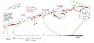
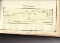
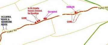
Does anyone here Know how to Lay a map over another ?

It's beyond my Knowledge at this point.

I understand they wont be exact being 1875 over 2007
but it may help with home research, till I can get there.
and a starting point when there.
 

Attachments

  • Taylorsville_N_Glen_Carbon_Foster_twp_1875.jpg
    Taylorsville_N_Glen_Carbon_Foster_twp_1875.jpg
    44.1 KB · Views: 485
  • Taylorsville_N_Glen_Carbon_Foster_twp_2007.jpg
    Taylorsville_N_Glen_Carbon_Foster_twp_2007.jpg
    47.9 KB · Views: 479

RON (PA)

Silver Member
Sep 9, 2004
2,847
61
Pittsburgh, Pa
Detector(s) used
Tesoro Compadre & Tiger Shark
Jeff,

I don't know how to do it using the computer. What I do is to take the maps to Kinko's, Sir Speedy, or a copy center and see if they can make transperencies that are used for overhead projectors. I have each map put on each sheet. Then I overlay the new map onto the old map. By using a transparency it makes it easier to line up roads and other landmarks and to see what is there and what is gone. Hope it helps.
 

HMS Beagle

Jr. Member
Jan 28, 2007
81
23
wny
Detector(s) used
Garrett 250 :: Tesoro Compadre :: Equinox 800
Jeff,
If you have "photoshop" or another program that allows you to utilize layers, i will be more than happy to post a tutorial on doing "layovers".
It's really not diffucult, it will take a few times before you will be comfortable with the process. But well worth the learning curve. ;D
Beagle
 

OP
OP
jeff of pa

jeff of pa

Super Moderator
Staff member
Dec 19, 2003
86,207
59,962
🥇 Banner finds
1
🏆 Honorable Mentions:
1
Primary Interest:
All Treasure Hunting
I don't see anything for Layers Beagle,

I have Set Transparent Colors, But Don't know if that's the same.
 

HMS Beagle

Jr. Member
Jan 28, 2007
81
23
wny
Detector(s) used
Garrett 250 :: Tesoro Compadre :: Equinox 800
jeff of pa said:
I don't see anything for Layers Beagle,

I have Set Transparent Colors, But Don't know if that's the same.
Jeff,
what program are you using?
Beagle
 

OP
OP
jeff of pa

jeff of pa

Super Moderator
Staff member
Dec 19, 2003
86,207
59,962
🥇 Banner finds
1
🏆 Honorable Mentions:
1
Primary Interest:
All Treasure Hunting
I have Microsoft Photo Editor

& Paint
 

HMS Beagle

Jr. Member
Jan 28, 2007
81
23
wny
Detector(s) used
Garrett 250 :: Tesoro Compadre :: Equinox 800
Jeff,
I don't believe either of those will accomodate layering. I will inquire on another forum i frequent, and get back to you. :)
Beagle
 

HMS Beagle

Jr. Member
Jan 28, 2007
81
23
wny
Detector(s) used
Garrett 250 :: Tesoro Compadre :: Equinox 800
Jeff,
Sorry to say those do not support layers. :(
Beagle
 

OP
OP
jeff of pa

jeff of pa

Super Moderator
Staff member
Dec 19, 2003
86,207
59,962
🥇 Banner finds
1
🏆 Honorable Mentions:
1
Primary Interest:
All Treasure Hunting
Thanks Any Way Beagle !

I Scanned the one Map on Plastic & with a little Manouvering
was able to match up Every Curve in the Road.
And Using a Pin & marker, I was able to Get this.
Which is a Start.
 

Attachments

  • Copy of overlay.jpg
    Copy of overlay.jpg
    32.1 KB · Views: 448

laralucine

Sr. Member
Dec 27, 2004
415
24
S.E. PA
Detector(s) used
Minelab Equinox 800 Minelab X-Terra 50
Primary Interest:
All Treasure Hunting
Jeff,
Sorry if you know this already and are looking for a way to do this without Google Earth. With it, you can find the location and match up the image w/ the current map you have (eyeball it). Then go to "Add" on the menu in the upper left, and choose "Image Overlay". A dialog box will come up and there's a space where you can "browse" for an image to overlay (like "Browse" for attachment when posting here, you choose your 1875 map from wherever you have it saved on your computer). It will just drop it on the satellite image, and you can turn it and resize/stretch the overlay and save it - you can also shift it from transparent to opaque to compare current landmarks, etc. I can email you an example, but you would need to have GoogleEarth downloaded in order to open it. It really works well.
good luck!
LL
 

EDDE

Gold Member
Dec 7, 2004
7,129
65
Detector(s) used
Troy X5
Primary Interest:
All Treasure Hunting
jeff of pa said:
Thanks Any Way Beagle !

I Scanned the one Map on Plastic & with a little Manouvering
was able to match up Every Curve in the Road.
And Using a Pin & marker, I was able to Get this.
Which is a Start.
try using tracing paper next time
in place of plastic
then overlay the trace to the map below
just trying to help *sniff* :'(
 

OP
OP
jeff of pa

jeff of pa

Super Moderator
Staff member
Dec 19, 2003
86,207
59,962
🥇 Banner finds
1
🏆 Honorable Mentions:
1
Primary Interest:
All Treasure Hunting
Google Earth don't work on my Computer Lara.
It worked like a Virus Both times I tried.

Dekalb I have thought of that.
I'm Stuck at home right now with out My Vehicle yet,
So I can't get to the store.
 

laralucine

Sr. Member
Dec 27, 2004
415
24
S.E. PA
Detector(s) used
Minelab Equinox 800 Minelab X-Terra 50
Primary Interest:
All Treasure Hunting
Ooops, sorry! Well, if you want, I can try it and send you a copy of the image somehow, if you do just pm me:)
Lara
 

CWnut

Hero Member
May 9, 2003
591
37
E. Tennessee
Detector(s) used
Tesoro tigershark----Tesoro Conquistador Umax------Fisher FX-3----Master Hunter CX-Plus w/ depth multiplier
Primary Interest:
All Treasure Hunting
Jeff, "Interpreting History from Relics Found in Civil War Campsites" has a short tutorial that may be of some use to you...have a good'un
 

Top Member Reactions

Users who are viewing this thread

Top