Maps

mrs.oroblanco

Silver Member
Jan 2, 2008
4,356
427
Black Hills of South Dakota
Detector(s) used
Tesoro Lobo & Garrett Stinger
Primary Interest:
All Treasure Hunting
Lot's of heads around:

SupeRockHead.jpg


PrayingIndian.jpg


These are two pretty good one's.

Good luck,

Joe Ribaudo

I like it, Joe.

Here's my Superstition Head:

stone face (c).jpg
 

Treasure_Hunter

Administrator
Staff member
Jul 27, 2006
48,543
55,131
Florida
Detector(s) used
Minelab_Equinox_ 800 Minelab_CTX-3030 Minelab_Excal_1000 Minelab_Sovereign_GT Minelab_Safari Minelab_ETrac Whites_Beach_Hunter_ID Fisher_1235_X
Primary Interest:
All Treasure Hunting
Posts deleted for being off topic, please keep posts on topic, topic is maps on LDM and Superstition Mountains...
 

markmar

Silver Member
Oct 17, 2012
4,120
6,263
Primary Interest:
All Treasure Hunting
Many treasure hunters are wondering where could be applied the Padres map and what is recognized in this map . I am here to give you the answer .
The map recognize a portion of a mountain range somewhere in the Superstitions .

PADRES map.jpg Padre's map.jpg
 

nobodie

Hero Member
Jul 17, 2015
596
887
Phx. A.Z.
Primary Interest:
All Treasure Hunting
markmar,
Look at the
Virgil Bowmen
map
Jesus S. Figueroa
1980
and match it to the Holmes map. They both show the LDM. The Bowmen map is up side down.
 

markmar

Silver Member
Oct 17, 2012
4,120
6,263
Primary Interest:
All Treasure Hunting
Hi

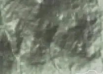
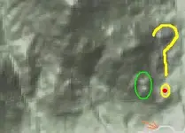
I want to show you a fragment of a physically topo from the region where I believe is the Wagoner's mine and to compare it with the clues which have from stories and maps .

First clue : is close to two black hills ( green colour ) .
Second clue : the question mark symbol from the Wagoner's map ( yellow colour ) .
The orange arrow ( is not an old clue but a new ) shows a trail .
The red dot is the mine .

Wagoner's mine region.JPG Wagoner's clues map.JPG

Wagoner clue.gif Wagoner's map.gif

Amazing how some clues fit to this topo . :key:

Happy New Year to all .
 

Last edited:

Hal Croves

Silver Member
Sep 25, 2010
2,659
2,695
i've never heard the story but the location is not too far from waltz's old homestead

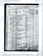
Old posted the 1870 Phoenix census and in the first column the caption reads "Houses dwellings numbered In order of visitation". At the top of the list is Waltz (#1). He is #19 in the list of homes visited. What I don't understand is that 13 people are recorded at this location including one Peralta. I may be understanding it incorrectly but that seems impossible unless it was some type of boarding house or estate with multiple structures on it.
 

Old

Hero Member
Feb 25, 2015
656
1,409
Virginia
Detector(s) used
Whites
Primary Interest:
All Treasure Hunting
Good morning Hal,

My understanding of how the census takers worked is that all persons found at one location are listed under that location number. Could be boarders, could be workers. Could even be visitors. If this is our Waltz I wouldn't find this number of people on a 160 acre site as being beyond reason. If I'm reading the accounts correctly Waltz planted a vineyard and orchard on his homestead. The census was taken at the end of August. Harvest time. That's a lot of work for one old man. Having help would have been almost required.

Just for fun, here's another interesting census record. Julia Thomas' maiden name was "supposedly" Corn. Not your run of the mill surname. Here's a Julia Corn age 12 as of 1870 (5 years difference), an Indian domestic, living with a Tomlinson family in Fort Scott, Kansas. Tomlinson list himself as born in Ireland and a photographer. I find a Parker & Tomlinson photography firm that worked with several army locations in the Southwest. Interesting???? Would be interesting to know what photography firm took the tin type photo that's said to be that of Julia. Anyone know?
Julia Corn - 1870.jpg
 

Hal Croves

Silver Member
Sep 25, 2010
2,659
2,695
Good morning Hal,

My understanding of how the census takers worked is that all persons found at one location are listed under that location number. Could be boarders, could be workers. Could even be visitors. If this is our Waltz I wouldn't find this number of people on a 160 acre site as being beyond reason. If I'm reading the accounts correctly Waltz planted a vineyard and orchard on his homestead. The census was taken at the end of August. Harvest time. That's a lot of work for one old man. Having help would have been almost required.

Just for fun, here's another interesting census record. Julia Thomas' maiden name was "supposedly" Corn. Not your run of the mill surname. Here's a Julia Corn age 12 as of 1870 (5 years difference), an Indian domestic, living with a Tomlinson family in Fort Scott, Kansas. Tomlinson list himself as born in Ireland and a photographer. I find a Parker & Tomlinson photography firm that worked with several army locations in the Southwest. Interesting???? Would be interesting to know what photography firm took the tin type photo that's said to be that of Julia. Anyone know?

View attachment 1255972

Morning Old,
What you wrote makes complete sense if they were temporary workers more or less squatting on the Waltz homestead and living in temporary shelters. There must be a plot map somewhere showing whatever structures Waltz owned on the property. When did Waltz first settled his homestead? 70' just seems early.

Very interesting about Julia and I would guess that TEGlover might know if anyone does.

What do you think about her map(s)? Do you think that they have any historical connection the Stone Maps? I bumped another thread this morning that raises some very interesting questions.
 

Last edited:

Hal Croves

Silver Member
Sep 25, 2010
2,659
2,695
Good morning Hal,

My understanding of how the census takers worked is that all persons found at one location are listed under that location number. Could be boarders, could be workers. Could even be visitors. If this is our Waltz I wouldn't find this number of people on a 160 acre site as being beyond reason. If I'm reading the accounts correctly Waltz planted a vineyard and orchard on his homestead. The census was taken at the end of August. Harvest time. That's a lot of work for one old man. Having help would have been almost required.

Just for fun, here's another interesting census record. Julia Thomas' maiden name was "supposedly" Corn. Not your run of the mill surname. Here's a Julia Corn age 12 as of 1870 (5 years difference), an Indian domestic, living with a Tomlinson family in Fort Scott, Kansas. Tomlinson list himself as born in Ireland and a photographer. I find a Parker & Tomlinson photography firm that worked with several army locations in the Southwest. Interesting???? Would be interesting to know what photography firm took the tin type photo that's said to be that of Julia. Anyone know?

View attachment 1255972

Old,
Hopefully, this information will not end up in one of Eeyors videos.

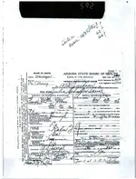
First Julia was considered black. She may have come from a mixed marriage but officially she was identified as black.
When she died of Brights Disease on 22 December, 1917, her name was Julia Schaffer Iseral.
She was fifty four years old and had been living in Arizona for some 35 years.
This means that she came to Arizona around 1882ish.
Julia was born in Louisiana on 25 December, 1863 (calculated year - not official).
Her father was born in Georgia and her mother, Louisiana.
She and her husband Albert (also known as Albert Schaffer Iseral) apparently lived at 137 West Jackson Street in Phoenix at the time of her death.
Before they were married Julia (Thomas) sold two lots in Phoenix to her future husband for $800 (July - 1893) so, she was far from destitute.
After they were married, Julia and Albert Schaffer, along with Englebert Schaffer, did file a claim. The MONTEZUMA, in the Salt River Mountain district in 1894 (21 February). This is two miles south of the main range and obviously NOT in the Superstitions. Albert filed several claims in the 1920's.

After Waltz passed, and after her marriage to Albert, Julia somehow assumed the roll of a religious leader and mountabank.
She became known as the Prophetess of Zion.

"To the public and people abroad, thus said the Lord God of Israel to Julia Schaffer, the prophetess of Zion: Fear God and keep his commandments, for He is coming upon them, and whomsoever will, let him come and take of the waters of life freely". AZR 24 June, 1902

Many of her victims were Papago who believed that Julia had the power to cure by "laying of hands".

A decent example of her craft: "A Papago woman was brought to the territorial Insane Asylum here to-day (6 Dec 1900). She became insane weeks ago over the religious teachings of a woman named Julia Schaffer who lives at Phoenix and whose strange delusions have been impressed on the Papagos to such an extent that many more of the Indians are practically demented". SFC 7 Dec, 1900

There is more but this should help you to get started if you are interested.
Almost forgot...
Julia's father's last name was spelled K A L N, her mother's Mannie.
She should still be there, buried in the "Jewish Cemetery" Phoenix.
There are several.:icon_study:
 

Last edited:

Old

Hero Member
Feb 25, 2015
656
1,409
Virginia
Detector(s) used
Whites
Primary Interest:
All Treasure Hunting
Hal,

Here's the document where all that information is coming from.

Julia - death certificate.jpg

I have Julia's probate file where Albert was appointed Administrator of her estate which consisted of her real estate owned in common with Albert. The bond is set at 19K which is not insubstantial for the time period. And; I also have Emil Thomas and Julia's marriage records (Dec. 1883) from Mitchell Co. TX.

I know I'm hard headed but I have some issues with the discrepancies between these documents. If you find these at all interesting we can discuss the differences. Not that they will get you one step closer to the LDM. I just find them interesting.
 

Hal Croves

Silver Member
Sep 25, 2010
2,659
2,695
Hal,

Here's the document where all that information is coming from.

View attachment 1256430

I have Julia's probate file where Albert was appointed Administrator of her estate which consisted of her real estate owned in common with Albert. The bond is set at 19K which is not insubstantial for the time period. And; I also have Emil Thomas and Julia's marriage records (Dec. 1883) from Mitchell Co. TX.

I know I'm hard headed but I have some issues with the discrepancies between these documents. If you find these at all interesting we can discuss the differences. Not that they will get you one step closer to the LDM. I just find them interesting.

Well, not exactly "all that"...:thumbsup: But yes, start with that document and if interested, follow the trail. The Maricopa Recorder's office is also a great source of info.

Honestly, my only interest is her interaction with the Papago.
And only because of her ability to deceive the masses.
Understanding deception (the mechanics of it) and its crippling effect on people is one of my goals in 2016.
From reading your posts, I think that we might share a few of the same thoughts on this.
It seems that our brains are wired to receive deception. TED talks has a great lecture on the topic.

As far as locating Dutch Jacob's mine with any map that Julia may have had or made, if she and the boys (HP&RP) could not follow it with success, I doubt any one can.
But I know that people continue to try.


Last edited:

Hal Croves

Silver Member
Sep 25, 2010
2,659
2,695
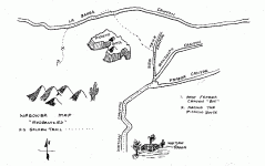
This is a drawing of and reproduced from an original map. I have not seen it shared here before but some of the words and symbols are very familiar. Anyone recognizes it? A very interesting story attached to it.


Hal Croves

Silver Member
Sep 25, 2010
2,659
2,695
Well Hal ?????

Its a treasure map made by a man who was thought to have eventually lost his mind but, there are some people who think that his map(s) were legitimate. Those who dismiss the idea of Jesuit treasure in AZ will not find it interesting. I am trying to track down the original because the drawing of it (the copy) looks more like a tourist place-mat than a treasure map.
 

Hal Croves

Silver Member
Sep 25, 2010
2,659
2,695


This map shows legally registered mining sites in Maricopa County (sub & surface) as of 1974(?). The arrow is pointing to a "void" in one of the two distinct data "bands" that cross the county. This void is the Apache Trail and Salt River area, the northern edge of the SWA including Mormon and Tortilla Flat.
 

Top Member Reactions

Users who are viewing this thread

Top