Maps

Curtis

Hero Member
Joined
Sep 3, 2008
Messages
906
Reaction score
1,021
Golden Thread
0
Location
Cincinnati
Primary Interest:
All Treasure Hunting
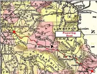
I am not sure if I posted these maps. Just ran across them in some old photos. They might help someone looking for the Warriors Path and other locations. Also a pic of the Indian stair steps near the monument rocks on Little Sandy indian stairsteps.webpKYYesterdayPioneerRoadsa.webpKYYesterdayKentuckyStations.webp and one of the balanced rock.balanced rock.webp
 

Nice stuff! From the Timmin's article in the other thread, there was an Indian trace from the Forks of the Kentucky River to the Mouth of the Big Sandy running NE-SW. On a map it would pass very near the Caney area and provide a way in and out of that area and the Lower Devil's Creek/RRG areas.

They had to use the traces to move in and out. From the trace to the mining locations would require the marks they made on trees and rocks and the landmarks they used to navigate.
 

Those maps like many others show no way through todays easternmost part of ky or w.Va. .
 

Very interesting stuff!
 

Those maps like many others show no way through todays easternmost part of ky or w.Va. .

Ken, I think that is why the other gaps never got used as much. Indians and animals knew those routes but the white men didn't...maybe because there wasn't as much bottom land to farm?
 

Guess that could explain why Swift had as much problems with the Indians as he did. Mundy would have known the trails through the area.
 

Those maps like many others show no way through todays easternmost part of ky or w.Va. .

Even though the majority of maps don't reveal it, there where two heavily used "routes" in place during this time frame, the Mt. Sterling-Pound Gap Road and the Rebel Trace. It was only during the Civil War that attention was drawn to these routes but both were in place in the late 1700's. The Rebel Trace pretty much parallels the Mt. Sterling-Pound Gap road but follows creeks and streams. The Rebel Trace is most likely the older of the two.
 

1320 thanks for your input! Did the Mt. Sterling-Pound Gap road follow the Mt. Pkwy route roughly from Clay City Southeast?
I just read the route for the Rebel Trace, follows the route I sorta mapped out through the Red River Gorge, Frenchburg South down Indian Creek to the Red River near Courthouse/Haystack Rock then East down river to Sky Bridge then South down Swift Camp Creek to Campton.
 

Last edited:
1320 thanks for your input! Did the Mt. Sterling-Pound Gap road follow the Mt. Pkwy route roughly from Clay City Southeast?
I just read the route for the Rebel Trace, follows the route I sorta mapped out through the Red River Gorge, Frenchburg South down Indian Creek to the Red River near Courthouse/Haystack Rock then East down river to Sky Bridge then South down Swift Camp Creek to Campton.

The Mt. Sterling-Pound Gap road began at Mt. Sterling and extended southeast through Hazel Green, Licking Station, Prestonsburg, Laynesville and Pikeville to the Virginia State Line at Pound Gap. Roughly the same route as today's US 460.
 

Attachments

  • Capture.webp
    Capture.webp
    133.1 KB · Views: 251
The Mt. Sterling-Pound Gap road began at Mt. Sterling and extended southeast through Hazel Green, Licking Station, Prestonsburg, Laynesville and Pikeville to the Virginia State Line at Pound Gap. Roughly the same route as today's US 460.

Gotya, I think Boomer had said that 460 was originally a Buffalo Trace. Would make sense that it would become an early road too. I have never been to Hazel Green, I have been reading their newspaper articles about Mrs. Rebecca Timmins in the late 1800s a lot though.

That last stretch to the South of Prestonsburg goes right through land that was owned by Swift, Montgomery and others according to this video of Prather's presentation in Prestonsburg. That sheds new light on things related to Swift legend and his probable route.


Last edited:
Interesting stuff. Hazel Green is a very interesting and old community. I’ve actually been researching its history and have gotten permission to detect a lot of property there. Was actually there this past weekend detecting an old home. The cemetery is one of the most beautiful I have ever seen. There are several prominent men that lived in the area in the 1800s buried there. Their monuments are like those I have never seen. There is a Revolutionary War soldier buried there and there is a grave of a little girl who passed away in 1806 which shows how long that area has been populated. Interesting little place.
 

1320, ever get out to Olympia Springs anymore? Would love to join you again one day.
 

Interesting stuff. Hazel Green is a very interesting and old community. I’ve actually been researching its history and have gotten permission to detect a lot of property there. Was actually there this past weekend detecting an old home. The cemetery is one of the most beautiful I have ever seen. There are several prominent men that lived in the area in the 1800s buried there. Their monuments are like those I have never seen. There is a Revolutionary War soldier buried there and there is a grave of a little girl who passed away in 1806 which shows how long that area has been populated. Interesting little place.

Find out that soldier's name, he was alive when Swift was alive and they may have known each other. The country was much smaller then! Chances are good that soldier, if an officer, was their because of land granted to him as back pay for the war.
 

His name was Michael O'Hair. Says he was born in Ireland but not sure when he moved to that area. Here is some information about who he served with in the War on "Find a Grave." https://www.findagrave.com/memorial/13135650/michael-o_hair

Thanks E.C. Mason! Looks like he served as a Private. He might have known a 5 great uncle of mine on my mother's side who died (like many did) at Valley Forge, PA. He was attached to Gen. Washington as a personal guard and my mom's family was from Harlen, KY. He probably came to KY toward the end of the war if he served under Gen. George Rogers Clark. Still good info...always good to learn more about our founding patriots, they had it hard during that time and they should never be forgotten!
 

Since this thread is about maps, does anyone have a link to or copy of the 1797 Gilbert Imlay map of KY? Seems the only ones I can find have been altered...it no longer says at the headwaters of the three forks of the KY river 'reputed silver mines' . It now says 'The Narrows'... Or was the copy I used to have altered? Or do I have this map confused with another map?
 

Totally agree KY Hiker. That cemetery is full of soldiers of all wars. A Lot of Civil War graves. Very sombering.
 

Top Member Reactions

Users who are viewing this thread

Back
Top Bottom