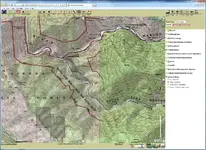
Mergen North Fork Preserve Placer County ca

MadMarshall

Hero Member
Joined
Nov 12, 2012
Messages
944
Reaction score
1,635
Golden Thread
0
Location
na
Primary Interest:
Prospecting
So I have just found out that That 160 acres between Mineral Bar and Yankee jims on the North Fork American river has been sold. to the placer land trust MERGEN NORTH FORK PRESERVE... well firstly I had no Idea that the river was owned in this area.. I have spoken (Argued) with ASRA and BLM about Sore Finger Point Between Yankee Jims and Ponderosa..I was assured that was the only property owned! It doesn't take a rocket scientist to know what this means for prospecting in that area.. The ASRA is now taking a somewhat offensive against prospecting in their state park. In 2010 ASRA tried to go hands and pans and from what I understand thru the efforts of the GoldHounds it was stopped.. Anyway I figure the next time they will try they will win.. For now Wild and Scenic of the North fork is still prospector friendly.. Though its a rugged place. Over the last few years I have noticed a decline in trail upkeep. And an increase in trash and tagging and carelessness.. It seems the ASRA would rather be making money and catering to the need of their pocket books. They rather have tourits on their lands. And make no mistake it is their land!!! Broken rocks will give way to broken beer bottles. All my activity in the area is over.. My brother and I both agree let them wreck it.. Though we love the area and have spent a many year enjoying it awesomeness and the history of the area..(lots of history lots of forgoton trails mines cabin sites)..The times dictate a change. a person must adapt and overcome.

Also for a while now I have noticed Bright red signs on BRUNCH CREEK .. Untill the other day I ignored them but finally being disturbed by their unnatural presence I took a look..
It say the creek has a possible water contamination though I cant find any info on what this contamination could be.. Was wondering if anyone might know?
 

Upvote 0
Ok, I will post my ignorance.

Clay Diggins, I notice in the above reply discussing how you gather information about "the land" your last sentence ends with "there are no shortcuts to getting the information onto our maps". What maps are you speaking of? I've no clue!

Thank you.........................63bkpkr

As I'm sure you know 63bkpkr every prospector has the legal obligation to know the status of the land before they prospect it. We learned this essential prospecting skill years ago and have had good success mapping the areas we intend to prospect.

There is more land open to prospecting than most people suspect. No need for a club membership or your own claim when you see just how much land can be legally prospected. Even well known gold producing districts have open areas that would never be revealed without mapping out the various land designations and mining claims.

Prospectors are always eager to find good areas to prospect and our prospecting friends are no exception. We began sharing our maps with friends. It didn't take long before word spread and prospectors we didn't even know wanted to see our maps. Now we make maps of gold districts pretty much full time. We still get out to prospect pretty regular but our "work" time is taken up making maps and our "play" time is spent prospecting. We get to see some great areas of the country and know things about many gold districts than most of the people that have prospected them for years have never discovered.

It would be impolite and probably against the rules here to direct you to our maps and I don't post here to advertise. Anybody with the desire to learn how to map land status and claims can learn how. We like to encourage others to learn all the skills behind prospecting including determining how to find open ground to prospect. It's not only a vital skill for real prospecting it's a legal requirement for those who want to move outside the prospecting club environment.
 

For quick reference, go to LR2000, zoom the map into the area and then check the Topo Map NGS button on the bottom right of page, patented claims show up as a darker gray color tone. That area has patented claims all over the place.

Uh ... there are no maps on the LR2000 spillercanyon. Maybe you mean another system that has maps? Could you share the link?
 

Uh ... there are no maps on the LR2000 spillercanyon. Maybe you mean another system that has maps? Could you share the link?

Right you are Clay, I just go through LR2000 to get to the maps by going to GeoCommunicator then interactive maps. The grayed areas are on most topo maps though. Here is a screen shot of the South Fork of the Merced River, notice the patented claims at Sout Fork as well as just south west of South Fork.
 

Attachments

  • MercedRiver.webp
    MercedRiver.webp
    487.1 KB · Views: 109
So you are using the geocommunicator maps. The geocommunicator map and the LR2000 database are entirely different and unrelated systems, that's why I was confused. You can get to some functions of the LR2000 from links in the map query returns but the geocommunicator is an entirely unrelated government program.

Those are private lands, or non Forest lands, within the Forest. The ones right on the South Fork look like they are probably mineral patents and the ones on the ridge might be placer patents but the map is just showing lands that were not included in the Forest. They could be homestead patents or sale patents or railroad patents or any other type of private or non forest land. We can't know which they are from the map. Usually if the patent was not granted for minerals (the majority of patents were not for minerals) the minerals still belong to the US.

You can take the TRS info from the map and look up that area at the Government Land Office to see what patents (if any) are there and what they were granted for but the map itself doesn't distinguish mineral patents from other types of non Forest land.
 

Top Member Reactions

Users who are viewing this thread

Back
Top Bottom