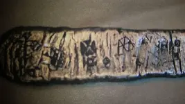
Misc data and adventures of a Tayopa treasure hunter

KANACKI

Bronze Member
Mar 1, 2015
1,445
5,932
Primary Interest:
All Treasure Hunting
Time once again upon us.

Soon I will see gone again?

I and my better off to Saipan for 2019 Pan Pacific wrestling championships in Guam. We are going to meet up with our son who is competing. He is coming from Hawaii where he is studying medicine.

Coffee?

Well after wellington we sailed down the east coast south island of New Zealand. Then hit the choppy rolling seas and a strong south wester. The further south the bigger the rolling swells and occasionally rolling swells smashing over the deck of the Drumbeat. The mood on drumbeat changed as most of crew have never experienced the southern ocean. This is ocean that really tests the skills of mariner. With tasks everyone was paired up in buddy system on each shift. No one on board doing some thing by themselves. My biggest fear is mistake by tired crew and some one gets washed over board.

George told me a terrible story when he was on the "Picton castle" one of crew disappeared over the side in Atlantic....the loss was a devastating for crew racked with guilty losing one of their own. But even more so for the skipper who is responsible for the welfare of his crew.

At night we practical everyone is tethered to a harness especially in forecastle and boat deck vulnerable to big waves. But the Drumbeat was different in design than the Picton. The drumbeat much smaller with much less items lashed to the working deck. Even so the Southern ocean is just as unforgiving as the north Atlantic.

In case Laura Gainey her death was not in vain. Because it created a whole new raft of safety measures to prevent such a tragic accident again.

The ocean I know can eat ships not leaving a trace. And where we was going had a long record of eating such ships leaving them missing without trace. Simple factor I hammer home to the crew if you go over the side your dead. The simple fact in the matter.

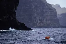
The further south we went the sea changed from calm temperate to angry windy ocean. Where working on deck meant being cold and wet. We sail through several squalls south of new Zealand. finally through rain hail and sleets we came to Auckland islands. I was depending on the weather tack until daylight to north of the islands then sail during the day around. down the rugged west coast of the island. However we had few frustrating days of very poor weather. However in the end we resorted to east coast protects by big winds and storms and landed in bay of Enderbury Island.

Auckland island are sub Antarctic island with their very own unique mega fauna. the one small beach was crowded with seals that took exception us us land with zodiacs. We could not explore for because of thick vegetation and very changeable weather.

However after about two days the weather gave up break but the temperature had dropped dramatically as islands was sprinkled in snow.

Sailing down the south coast of Auckland it is easy to imagine how terrify it must of been being in sailing ship with no engines only sails being pushed to a coast line of cliffs that had caverns as big enough to swallow ships? The picture below is of the cavern believed the General Grant got washed into? The the fact of the matter there was several cave equally in size that could be been also the site of shipwreck?
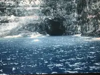
img_0115.jpg

Crow and mine opinion was if there was any gold it might of been in the strong box of the ship? If the ship smashed to pieces in cave the part of ship could floats out carrying the strong box until it sank miles away from the cave.

Knowing the story and seeing the caves along cliffs still gives me shivers. So I time was there short we had circumnavigated the Auckland islands then headed east to another little known island.

Kanacki
 

Oroblanco

Gold Member
Jan 21, 2005
7,838
9,830
DAKOTA TERRITORY
Detector(s) used
Tesoro Lobo Supertraq, (95%) Garrett Scorpion (5%)
hadn't thought of it ORO, but will do so. Glad to see you posting, keep it up. For those that don't know him I sttill like and respect him, in spite of rejecting ME on the Tayopa project ORO was my first choice as a partner on the Tayopa project, but he turned ME down, sniff. In spite of that I like him personally and respect him and his lovely wife - Beth. Welcome back my friend. ( you're the only other, that has procrastened as long as I have on a book - something about mixed commands in the battle of The little big horn.)


Thanks for the kind words amigo, however undeserved. I could not be your partner as I had done nothing to earn it, and did not have the financing to support the operation in the way it needs to be done. You need a partner with some financial wherewithal, not one of those "men who don't fit in" types like me.

And yes I am still working on the Custer thing, trying to get through a bit every day. It is not quite the same thing as your own book, since I must hunt up the source materials while you need only sip your coffee and recall your former life! And I believe I can see the end of the tunnel on my project, hope you are nearing completion of your book too.

Please do continue, I must admit that thought of the castaways with nothing but what could be salvaged from the wreck, on one of the most inhospitable islands in the world and yet were able to survive.

Now Don Jose', how about the Border Patrol?

Coffee - absolutely!

:coffee2: :coffee: :coffee2: :coffee2:
 

KANACKI

Bronze Member
Mar 1, 2015
1,445
5,932
Primary Interest:
All Treasure Hunting
http://www.treasurenet.com/forums/attachment.php?attachmentid=1701730&d=1554946861

Kanacki, is the color change of the water, near the entrance, from fresh water flowing out and pushing the sea water back????

I have seen videos of the line, videoed from beneath the surface, but never from above.

Just curious....

#/;0{>~

Hello PM

I am not sure? I was concerned with other things. A sailing vessel does not make a good salvage vessel and I did not want to loiter too long as there was break in the winds and swell. I had A vessel being pushed by the wind and swell on the beam ends. Even with my Caterpillar engines with little room to move. I did not want to repeat the fate of the General Grant in day light. We hauled out to south of the island and tacked sailed around the eastern side of the island in Carnley harbour.

Kanacki
 

KANACKI

Bronze Member
Mar 1, 2015
1,445
5,932
Primary Interest:
All Treasure Hunting
Hello All

The Auckland islands have many mysteries and secrets my friends. Not just 11 known shipwreck but other quirks of history. For example.

It was suspected that the 6,000-ton German merchant vessel Erlangen, which had sailed from Dunedin, supposedly for Australia, on 26 August 1939 – shortly before war had been declared in Europe – had, instead, supplemented her meagre coal reserves with timber from the Auckland Islands and headed for South America.

The suspicion was later confirmed when the first coastwatchers in the program found areas of newly cut Southern Rata forest at Carnley Harbour on Auckland Island. Moreover, the loss of the ships SS Holmwood and MS Rangitane to German raiders in November 1940 gave rise to the suspicion that the raiders were using the subantarctic islands as bases.

The above story was years later twisted into a conspiracy story of a secret Nazi submarine base.

Kanacki
 

KANACKI

Bronze Member
Mar 1, 2015
1,445
5,932
Primary Interest:
All Treasure Hunting
Hello again have you got your coffee?

Definitely need it down there. Never saw rain blow horizontally, but I did down there talk about wet and miserable. Even in summer there is no guarantees in weather. Today the islands are visited although you need a permit. Even by adventure Cruise ships on their way to Antarctica.

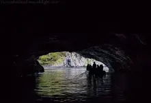
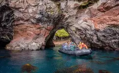
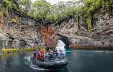
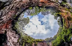
The island has many secret caves and inlets inside Carnly harbour. Such as in the pictures below. you can take a small zodiac boat into a cave and come out into secret sinkhole in the middle of the island. Absolutely awesome.

musgrave inlet auckland island cave.JPG

musgrave inlet auckland island.JPG

mugrave inlet.JPG

musgrave inlet.JPG

The wildlife is pristine. Our short time there was reward enough. As you see in picture below before the weather turned to snow. 3 minute later gust of wind and sun would come up. The sky changed about like a kaleidoscope of clouds in the sky if sped up? It felt like the weather was changing every 15 minutes or so.

The west coast where the General Grant was wrecked was just one solid wall of about 900 ft high cliffs. with gigantic sea caves carved into them. We counted at least 12 maybe more.

general-grant-ship-e23ab815-fc23-4744-9558-361bc94b2b4-resize-750.jpeg

Bill day spent well over a million I think his last expedition was 2007. But the reality is chances of ever finding the strong boxes holding the gold is very slim and the cost may just out weigh any return for the effort. Anyone wanting to visit the island adventure Cruise ships visiting the islands as well as other sub antarctic s island on Eco voyage down to Antarctica, Ship sail from New Zealand.

Just sailing down there was a treasure enough for me my friends.

Kanacki
 

: Michael-Robert.

Bronze Member
Feb 2, 2013
1,463
2,070
Sovereign America
Detector(s) used
Many
Primary Interest:
All Treasure Hunting
Wow! :coffee2::coffee2:

Sure looks like it has a lot of hiding places for treasure of all types. I believe there are a lot of true tales of this area. With missing and hidden treasures, along with tales of mishap.... Makes me wonder how much that "strong box" is estemated be valued at?? And exactly is expected to be in it?
 

Last edited:

KANACKI

Bronze Member
Mar 1, 2015
1,445
5,932
Primary Interest:
All Treasure Hunting
Wow! :coffee2::coffee2:

Sure looks like it has a lot of hiding places for treasure of all types. I believe there are a lot of true tales of this area. With missing and hidden treasures, along with tales of mishap.... Makes me wonder how much that "strong box" is estemated be valued at?? And exactly is expected to be in it?

Hello embrym about 3.3 million give or take. 2576 ounces in bags of gold dust from the Australia gold fields.

But here's the catch the strong box went down with the general grant. after the ship got smashed to pieces inside the cave.the ship was loaded with bales of wool which no doubt added buoyancy to the ships shattered hull. Although sunk the wreckage floated off in large chunks depositing its cargo over a large area of sea floor before fully sinking.

Kanacki
 

: Michael-Robert.

Bronze Member
Feb 2, 2013
1,463
2,070
Sovereign America
Detector(s) used
Many
Primary Interest:
All Treasure Hunting
Hello embrym about 3.3 million give or take. 2576 ounces in bags of gold dust from the Australia gold fields.

But here's the catch the strong box went down with the general grant. after the ship got smashed to pieces inside the cave.the ship was loaded with bales of wool which no doubt added buoyancy to the ships shattered hull. Although sunk the wreckage floated off in large chunks depositing its cargo over a large area of sea floor before fully sinking.

Kanacki

Kanacki,

So, somone spent 1 million trying to recover 3.3 million then gave up? Makes me think there might be something else tied to this tale.... But a great one, it is. Not saying ,of course, that that isn't a good ROI.
 

KANACKI

Bronze Member
Mar 1, 2015
1,445
5,932
Primary Interest:
All Treasure Hunting
Our return was via even further south east to Campbell island. We had a few good breaks in weather although we had one or two cold snaps where ice was forming on the rigging of the Drumbeat.

On Campbell island there is lone grave. The legend tells about the grave "Lady of the Heather" The story is about a daughter of Bonnie Prince Charlie, exiled to Campbell Island after she is suspected of treachery to the Jacobite cause. Her character was inspired by Elizabeth Farr. Farr was probably what would now be called a "ship girl", but the presence of a European woman at this remote place, and her death, gave rise to The Lady of the Heather story

Even so the lone grave among flowers in such a remote place. teaches us the tenacity people had in the past who went out into the far flung places of the world to settle , live and die. I cannot imagine the hardships living on these remote islands? Even today with a few mod cons at meteorological station. The island is world heritage location with amazing bits of flora and fauna.

So my friends they you have it. Lost tales of the Antipodes.

A voyage from equatorial tropical seas down into temperate seas. Down into sub antarctic seas. You had hear stories of cannibals, WW2 plane and shipwrecks. Lost city, lost gold mines, pirate treasure. pirates, black birders, whalers, shanghai dens, shipwrecks and incredible tales of survival.All these places have a story to tell my friends. Once again I have to go as fair wind beckons off to Saipan.

May the yarns flow freely my friends and coffee stays warm. I am sure Don Jose is revved up to tell us few yarns...

Coffee?

Kanacki
 

Last edited:

KANACKI

Bronze Member
Mar 1, 2015
1,445
5,932
Primary Interest:
All Treasure Hunting
Kanacki,

So, somone spent 1 million trying to recover 3.3 million then gave up? Makes me think there might be something else tied to this tale.... But a great one, it is. Not saying ,of course, that that isn't a good ROI.

Hello embrym life would be boring would it not if we knew the answers to everything?


On the ships manifest there was 9 tonnes of spelter. Spelter usually refers to Zinc or copper Zinc? There is wild speculation that this Spelter was not zinc or copper but unprocessed gold ore? Is that true or just wishful thinking I leave that to you.

Some times a lost treasure is better to remain a lost treasure?

Kanacki
 

Real of Tayopa

Bronze Member
Sep 4, 2016
1,942
9,101
Mexico
Primary Interest:
All Treasure Hunting
Kanaci, Guam is another of my old stomping grounds, Agana, naval air field, b-26, later A-26 stepping stone to old China. How much does that much Gold weigh, to answer Em.
 

coazon de oro

Bronze Member
May 7, 2010
1,625
3,863
texas
Primary Interest:
All Treasure Hunting
Howdy KANACKI,

That was not just a great yarn, but a great virtual experience that I had going along, seeing new places and learning more history. I also suspected yellow spelter being actual gold.

Have a safe trip, wishing your Son the best in his competition.

Homar
 

PROSPECTORMIKEL

Silver Member
Mar 31, 2011
2,624
9,424
N/W ARKANSAS
Detector(s) used
FISHER
Primary Interest:
All Treasure Hunting
Hello PM

I am not sure? I was concerned with other things. A sailing vessel does not make a good salvage vessel and I did not want to loiter too long as there was break in the winds and swell. I had A vessel being pushed by the wind and swell on the beam ends. Even with my Caterpillar engines with little room to move. I did not want to repeat the fate of the General Grant in day light. We hauled out to south of the island and tacked sailed around the eastern side of the island in Carnley harbour.

Kanacki


Kanacki, I didn’t necessarily mean that exact one... just in general.

I did wonder if it might have been enough of an outflow to push the logs, with that part of the ship, attached, far enough to redistribute the bags of gold into the open sea currents...

Having never been out to sea, myself, I thought you might have noticed the phenomenon at a less threatening situation.

By the way, you do post amazing photos of many places in peril!

Those places and moments in time, are important historical records.
I, everyone for that matter, hold those photos in high esteem.

Most of us will not have any other way to see the world that you have traveled, nor the life that you have lived, without your photographic records! And your wonderful yarns.

There is a name for that boundary between fresh water and sea water, but my Swiss cheese 🧀 memory fails to retrieve it. But I have seen it in a video, and if I remember correctly, the fresh water rises up and over the sea water until it is forced to submit to the sea.

Perhaps you may have seen it from your island home, where the stream enters the sea.

I have no way of knowing, but to ask.

#/;0{>~
 

: Michael-Robert.

Bronze Member
Feb 2, 2013
1,463
2,070
Sovereign America
Detector(s) used
Many
Primary Interest:
All Treasure Hunting
JOSEPHINA DE LA MARTINIQUE Mine(ca 1814)
....A bankrupt Spanish King was to rule the new world with old traditions. Servitude and slavery imposed by His Majesty and sanctioned by Catholic Priests, exploited for mining, the indigenous populations. The Padres were accountants, allied to the king in the huge profits and settlements for the mining masters. This gold bar(pictured below) is a result of that lust for gold, lost forever by the owner. It was reportedly recovered at Hoyt’s Peak, Utah and could be over three hundred years old. An accumulation of sixty five hundred ten pounders wereabandoned in a mine because of hostiles. Are they still there? Note: With Spanish WayBill (waybill being found in Seville, Spain and being transfered/stored in the BYU library archives. )


A verbal map authenticated by experts charts a course to the mines. Have I discovered a cryptic starting point that fills in the coordinates leading me to the main treasure mine, as penned by the Author Jose Juaquin Garcia? Proving he indeed “Chart a Course” for future miners? When in the mine, and 132 feet from the portal, then dismantle a log door and dig up 65,000 pounds of bar gold now worth nine hundred and ninety six million dollars, buried 20 feet from the log jam. One year’s recovery, but just a small bead, when weighted to the ultra-high grade ore in tunnels beginning at the four hundred fifty foot level. “Is of the yellow metal which is half of silver and one fifth part of gold.” Spanish Archives cataloged scores of mines for two hundred and fifty years, in the fifteen square mile area that are tunnels and miles of precious metals, abandoned because of hostiles, and there lain adrift. What immense revenue will Hoyt’s Peak Josephine’s generate with modern mining technology?
Trillions!! So I studied the English translation of a BYU Historian, Professor Russell R. Rich, who had discovered the document in Mexico’s Archives. I also studied Gale Rhoades version, who sold the Josephine as on his claim and that evoked supernumerary possibilities. Rhoades buttonholed John Young, Rich’s friend, that was a cattleman on Hoyt’s peak, who had found the Spanish cave. The document does not pinpoint the cave as the mine although Young found Spanish tools and shafts. Outside, was a dump and mining tools suggesting a smelter, support for a mining operation? Locating a series of mines would confirm a treasure house on the eastern slopes of Hoyt’s peak and I found scores of mine depressions with trails, leading to the Josephine. On the same trail, the cryptic starting point, an oval shaped ancient Arrastra (mill).
Hoyt’s geographical patterns show the same evidence of economic mineralization as the legendary pioneer mines mentioned by Lincoln when he declared, “Utah is the treasure house of the nation.” If the quality and extent of Josephine’s layered masses of gold ore are proven, as described, it would surpass the Park City, Alpine, Cottonwood, Tintic and Minersville mines combined yield. When there is a mine there is a smelter, and the document describes four lower rooms. “These rooms served as workrooms for the transfer of the mineral silver and gold,” In the rooms, fire pits would “transfer” silver from the ore, and at a higher temperature, the same ore to gold. An ancient cupellation process, then to bars? In the caves upper room, smelling of smoke, there were pictographs of animals unladen then laden. Chiseled rock beds in the walls allowed the mining teams to reside, process, and divide the labor of their slaves. Ranchers reported building a fire at the lower cave with smoke billowing out of the distant shaft and vestiges of The Spanish dump, still visible of attempts by Young to hide them. The Forest Service’s covered the cave before my claims tenure. But my appeal resulted in a concession to open and restore the cave ventilation. They have no jurisdiction in the cave or any tunnels, so mining activities can begin immediately under revised mining laws.
Links in next post...


A bankrupt Spanish King was to rule the new world with old traditions. Servitude and slavery imposed by His Majesty and sanctioned by Catholic Priests, exploited for mining, the indigenous populations. The Padres were accountants, allied to the king in the huge profits and settlements for the mining masters. This gold bar is a result of that lust for gold, lost forever by the owner. It was reportedly recovered at Hoyt’s Peak, Utah and could be over three hundred years old. An accumulation of sixty five hundred ten pounders wereabandoned in a mine because of hostiles. Are they still there? A bankrupt Spanish King was to rule the new world with old traditions. Servitude and slavery imposed by His Majesty and sanctioned by Catholic Priests, exploited for mining, the indigenous populations. The Padres were accountants, allied to the king in the huge profits and settlements for the mining masters. This gold bar is a result of that lust for gold, lost forever by the owner. It was reportedly recovered at Hoyt’s Peak, Utah and could be over three hundred years old. An accumulation of sixty five hundred ten pounders wereabandoned in a mine because of hostiles. Are they still there?
gold_bar Josephine Mine.jpg
 

Last edited:

: Michael-Robert.

Bronze Member
Feb 2, 2013
1,463
2,070
Sovereign America
Detector(s) used
Many
Primary Interest:
All Treasure Hunting
"Charted Course - Year - 1722 - 1814. This charted course pertains to the Mine of the Yutas: Named later the Josephine - of Martinique, the Empress. This mine can he found, west 12 leagues of the river Timpagos headland and 2 leagues from the entrance of the river Santa Ana to the Southeast---travel 1 league south by the land of the valley of grass to a can yon which enters the valley from the east, continue this canyon east to a peak rounded and barren of growth, and from the peak measure 1,600 varas to the northeast Al Pont de la Mina hay una picachos chico y maderaje alcance en la basa de negra chico bordeThe mine of the Josephine - of Martinique has 3 tunnels and 1 shaft--2 tunnels of 1200 feet to the west and 1 tunnel of 975 feet runs to the southeast The tunnels and shaft are 1 mine. The shaft runs 103 vertical and has 4 rooms and 6 tunnels. These rooms served as workrooms for the transfer of mineral silver and gold. 80 feet apart at Noonday looking to the sun arc the rooms. By percentage, the metal - namely yellow metal which contains half of silver and Fifth part of gold."


Last edited:

Top Member Reactions

Users who are viewing this thread

Top