My abbreviated theory for the Knights Templar treasure in Nova Scotia

ECS

Banned
Mar 26, 2012
11,639
17,694
Ocala,Florida
Primary Interest:
Other
So it is impossible to date, therefore you are claiming Woods Hole and Beta Analytic lied, very interesting speculation on your part!
As usual, Loki, due to either poor comprehension skills or deliberate attempt to twist what was stated, once again you have totally misrepresented what I posted.
No where have I ever posted that Beta Analytics or Woods Hole lied-their results were based upon the samples presented.
Now pay close attention, Loki, you too, Franklin.
There is a total lack of professional handling of these presented samples, they were not sealed and labeled at the time of in situ removal and some were displayed for many years in a museum, there is NO chain of custody PROVENANCE of the samples presented to the laboratories for C-14 dating, ie, without this sealed evidence chain from in situ to laboratory, other samples from another location could have been substituted to achieve fraudulent dating results.
What I also mentioned was the proven scientific fact, that coconut fibre biodegrades fully in 15 months when in soil.

With that stated, citing this coconut coir as an evidential foundation of a Templar presence on Oak Island has no structural merit on which to built a premise.
 

franklin

Gold Member
Jun 1, 2012
5,036
7,168
Detector(s) used
Garrett ADS-7X, Fisher Two Box M-Scope, Mother Lode Locator, Dowsing Model 20 Electroscope, White's TM808, White's TM900, Inground Scanners
Primary Interest:
All Treasure Hunting
Don't ever tell me again to pay attention. I could care less what you think or what you say.
 

SSR

Full Member
Sep 24, 2019
112
149
Primary Interest:
All Treasure Hunting
Polaris does not always stay "True North?" The only reason it was "True North" is because someone of the searchers around the Civil War Time laid it out that way. Why would anyone bury a treasure and leave a 10 or 12 foot pointer on the shoreline to exactly where the treasure was buried? Stupid Pirates, I guess. But Pirates did not have the know how to make large works of tunnels or shafts.

The Earth's Axis shifts from 22.1 degrees to 24.5 degrees over a period of about 40,000 years. The Earth rides up and down the scale every 12,900 odd years through two cycles of up and down, with all of these changes over years nothing stays "True North"

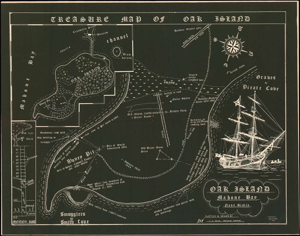
It is essentially in the same position it was now as when it was surveyed by Roper. The precession cycle takes roughly 26000 years. 80years/26000 x 360 degrees= roughly 1 degree since 1940. There is no other star to align with for N other than Polaris. It will continue to be the best beacon for a while. There absolutely is a True North. It's the position that never changes in the night sky when you look to it as the stars rotate around it. At that point is Polaris in these times. It's position remains the same at all times as seen by us. The next polar star will be located in Cygnus in another 3000 years. This was deduced in Europe in the early 1600s, and probably earlier but unappreciated then. In Egyptian times it was Thuben, not Polaris. Things are aligned with Polaris now, and that helps us to know it is put down in recent times as opposed to say in Greek or Roman times. There have not always been great polar stars. In Greek times they had their preferences. To navigate the Mediterranean they used what was later called the Mytre of St Peter and/or Triangulum, a perfectly straight (90 degree) triangular asterism that was directly above their heads South of the tip of Greece NW of Alexandria. In fact if you projected a straight line from this point where Triangulum is in zenith through the Pillars of Hercules it would intersect North America at Mahone Bay, NS (Haliburton's Chester Bay). This is something that had been realized by Francis Bacon since he uses that description of this alignment in his works. His knowledge of that little fact we can show.

It is with this knowledge of the OI location that Haliburton likely worked upon. He would have been intrigued as a Nova Scotian. I suspect the knowledge of this came to him through his relatives with which he spent significant time in the period immediately prior to writing "The Old Judge" vol. I. The same relatives later founded the Francis Bacon Society in England. Haliburton was likely all over the speculative Bacon ideas. That's how Bacon gets written into OI if you ask me. He understood that Bacon saw significance in this area in at least a few celestial ways. It is doubly significant because by the current position of Cygnus is in Zenith over the same area. This is the level of coincidence that Bacon loved to emphasize. Cygnus, of course, is the Swan that everyone wants to trace back to Shakespeare. The crazier notion that Bacon was Shakespeare was actually championed by Haliburton's niece Constance Mary Fearon Pott. About the same time she started publishing books about it the OI ground story shifted to the money pit being a chamber of manuscripts. People on the ground in NS have obviously been guided by the Burtons' ideas for a while. I suspect they were from day one in 1848 when these searcher shenanigans started.

The magnetic deviation you suggest isn't what you claim it is either. It varies wildly non linearly over time. To know exactly what it was at the time the island was first surveyed you can stumble over to the NS Department of Natural Resources site for a peek at the grant map where you can actually figure out exactly what the declination was at that time. It was not 30 degrees NE. Not even close. You are just spouting horrible information that will potentially impress those who cannot verify it.

There is no material "treasure" in Chester Bay. The correct question is what is the significance of OI in relation to the story it is part of, a story closely related to Haliburton's account. It's today more real than it ever was indented to be. It was most likely made that by individuals who sought to put down on the ground ideas they took inspiration from on paper out of admiration for one man's ideas about this place.

If you are looking to expand on the Cathar suggestions in Haliburton you will need to study up on Manichaeaism. Enoch's vault as a target is quite instructive, because in that mythology you can never reach the inner chamber exactly as you will never find the vault in the money pit today. The Enoch legend tells you that the walls will crumble and that the pit will fill with water right as you are about to reach it. Again, that's another detail of this modern story that mimics the old religious myths. The inner chamber is the knowledge of who you really are in the Enoch legend. That's part of the freemasonry take on your self awareness quest too.

OI is part of a great mythical allegory that was expanded upon by Haliburton and probably was staged by some Freemasons who see in him a father figure. It's certainly the case with Rosicrucians, a fraternal group that has many ties to the writing of the History of the OI mystery. The "Bible" of OI history was written by a NS Rosicrucian, Reginald Harris, as you know.

OI is like the Holy Grail or the Ark of the covenant in many ways. Don't be looking for those there, though. Halibuton was very shrewd when he predicted that men would die in shafts looking at the wrong spot for the wrong thing In Chester Bay. He does point you to your quest, though. You need to know who you really are. That was Francis Bacon's quest too.
 

Last edited:

franklin

Gold Member
Jun 1, 2012
5,036
7,168
Detector(s) used
Garrett ADS-7X, Fisher Two Box M-Scope, Mother Lode Locator, Dowsing Model 20 Electroscope, White's TM808, White's TM900, Inground Scanners
Primary Interest:
All Treasure Hunting
There is no material "treasure" in Chester Bay. Wrong totally wrong. There are at least four more Knights Templar's Treasures in Mahone Bay or as you call it Chester Bay. There are at least 9 more Knights Templars Treasures that were brought over in the 17th Century and they are scattered out over 2,000 miles across the US and Canada. You can quote all that Polaris information you want. You admitted that Polaris has changed one degree in the past 80 years actually it is 72 years. So since the Knights Templar's Treasures were buried in "Chester Bay" in 1398. The Star Polaris has been changed by over 8 degrees. Not much but over 450 miles on the ground------as above so below. Welling's Triangle was off 6.6 degrees and so is Nolan's Cross multiply that by 72 years and you will find they were constructed around 1545.
 

ECS

Banned
Mar 26, 2012
11,639
17,694
Ocala,Florida
Primary Interest:
Other
... the Chinese had been using declination since before Christ was born...
Actually the first use of the declination measurement by the Chinese has been documented and verified by professional historians as 720 AD.
 

Last edited:

Charlie P. (NY)

Gold Member
Feb 3, 2006
13,008
17,120
South Central Upstate NY in the foothills of the h
Detector(s) used
Minelab Musketeer Advantage Pro w/8" & 10" DD coils/Fisher F75se(Upgraded to LTD2) w/11" DD, 6.5" concentric & 9.5" NEL Sharpshooter DD coils/Sunray FX-1 Probe & F-Point/Black Widows/Rattler headphone
Primary Interest:
Metal Detecting
When Fred Nolan drew up his "Treasure Map" in 1974 he had all sorts of survey equipment available to him. He sold many of these to . . . (I don't know if P.T. Barnum called them "speculators" or something else that began with an "s").

It has been speculated by several that he placed the stones himself. He certainly did have a detailed knowledge of the structure of the pit. ;-)

OakIslandTreasure-nolan-1974.jpg
 

Last edited:

franklin

Gold Member
Jun 1, 2012
5,036
7,168
Detector(s) used
Garrett ADS-7X, Fisher Two Box M-Scope, Mother Lode Locator, Dowsing Model 20 Electroscope, White's TM808, White's TM900, Inground Scanners
Primary Interest:
All Treasure Hunting
Claiming another is "wrong" doesn't prove one is right.
 

ECS

Banned
Mar 26, 2012
11,639
17,694
Ocala,Florida
Primary Interest:
Other
When Fred Nolan drew up his "Treasure Map" in 1974 he had all sorts of survey equipment available to him.
He sold many of these to . . . (I don't know if P.T. Barnum called them "speculators" or something else that began with an "s").
It has been speculated by several that he placed the stones himself. He certainly did have a detailed knowledge of the structure of the pit. ;-)
Nolan also didn't mention Templars or coir on his "TREASURE MAP OF OAK ISLAND", only references to pirates and smugglers.
 

franklin

Gold Member
Jun 1, 2012
5,036
7,168
Detector(s) used
Garrett ADS-7X, Fisher Two Box M-Scope, Mother Lode Locator, Dowsing Model 20 Electroscope, White's TM808, White's TM900, Inground Scanners
Primary Interest:
All Treasure Hunting
Neither does claiming to be correct make it true.
 

franklin

Gold Member
Jun 1, 2012
5,036
7,168
Detector(s) used
Garrett ADS-7X, Fisher Two Box M-Scope, Mother Lode Locator, Dowsing Model 20 Electroscope, White's TM808, White's TM900, Inground Scanners
Primary Interest:
All Treasure Hunting
Nolan also didn't mention Templars or coir on his "TREASURE MAP OF OAK ISLAND", only references to pirates and smugglers.

And? Mine journals do not say anything about Pirate Gold either. Two different subjects. Just like your reference to Nolan what does that prove for you?
 

DaveVanP

Sr. Member
Oct 5, 2018
375
680
Coffeyville, KS
Detector(s) used
Minelab XTerra 705
Fisher F44
Primary Interest:
Prospecting
Your professionals not my professionals.

Only "professionals" that agree with him are "professionals"...
A lot of charlatans made a lot of money (making them "professional charlatans") sell their snake oil.
 

SSR

Full Member
Sep 24, 2019
112
149
Primary Interest:
All Treasure Hunting
Welling's triangle sits on the surveyed line of 1752 directly South of the MP location in the Roper survey. The offset in the triangle pointer points to the the intersection point of a circle arc with the stem of Nolan's cross if one draws it (shown). Here's a demo I did to illustrate and explain to a group.
FnD4Q6t.png

The blue line is the main Morris survey line that divides the lots. Take point c, a or b as Welling's marker. The offset value of the Welling triangle marker will always give you an intercept point on the stem of Nolan's Cross (shown in red). That offset is specific to a reference circle you can draw which I also show. The stem of the stone cross relates to a circle center on the main survey line. Nolan was apparently well aware of it because I was told he went looking for this spot at some point. It doesn't matter. What it shows is that Welling's marker on the main survey line of 1752 with the offset given are properties of the specific geometric arrangement of the main survey line and the stem of Nolan's Cross (their angle degree of separation). If you try with any other angle this does not work (see line in green as an example). That should be enough to make you realize that the three surveyed markers are related and that we can pretty confidently date any of this happening to 1752 or after.

If you persist in stating that this is much older then you have another small hill to climb. You' ll have to explain to us why it is that Morris divided the island the way he did with is main survey line that late served as road. Why on Earth would he, a lowly surveyor, know the alleged secrets of the Templars? What he or others knew he/they knew from his/their exposure to Freemasonry. This is recreating a geometric symbolism that itself is taken from the period of ca. 1600. It's not that old, and all it is is propagandized symbolism. The German settlers who assisted in the surveying knew enough to have local legends about there being geometric games being mapped out there.
 

Last edited:

DaveVanP

Sr. Member
Oct 5, 2018
375
680
Coffeyville, KS
Detector(s) used
Minelab XTerra 705
Fisher F44
Primary Interest:
Prospecting
Polaris does not always stay "True North?" The only reason it was "True North" is because someone of the searchers around the Civil War Time laid it out that way. Why would anyone bury a treasure and leave a 10 or 12 foot pointer on the shoreline to exactly where the treasure was buried? Stupid Pirates, I guess. But Pirates did not have the know how to make large works of tunnels or shafts.

The Earth's Axis shifts from 22.1 degrees to 24.5 degrees over a period of about 40,000 years. The Earth rides up and down the scale every 12,900 odd years through two cycles of up and down, with all of these changes over years nothing stays "True North"

True north/true south is the point around which the rest of the earth rotates. It is the "axel" or "spindle" upon which the earth spins. Geographically, it is 90° North latitude (or South)...and has no longitude. It does not move, and there is very little definite proof that it ever has. Magnetic north wanders, since it is based upon the rotation of the liquid/semi/liquid molten core of the earth. The "pole star" is just wherever the "spindle" happens to line up with at any particular time. Right now it is Polaris, (and has been since about 400 AD) in about 10,000 thousand years, it will be Lyra, a few thousand more, it will be somewhere in Hercules...and a lot of the time, there won't be any star directly aligned with the north pole...maybe there will be in the south...
 

DaveVanP

Sr. Member
Oct 5, 2018
375
680
Coffeyville, KS
Detector(s) used
Minelab XTerra 705
Fisher F44
Primary Interest:
Prospecting
So it is impossible to date, therefore you are claiming Woods Hole and Beta Analytic lied, very interesting speculation on your part!

Cheers, loki

No just saying they are ABSOLUTELY INFALLIBLE.

THEY will be the first to tell you that ALL their tests are subject to error.
 

DaveVanP

Sr. Member
Oct 5, 2018
375
680
Coffeyville, KS
Detector(s) used
Minelab XTerra 705
Fisher F44
Primary Interest:
Prospecting
Magnetic declination in the Halifax area is around a negative 17 degrees, which makes the use of the magnetic compass very difficult for accurate navigation, a point Samuel Champlain mentioned in his logs.

Cheers, Loki

What was the Mag Dec. in the 14th Century? I don't know...thought you did.
 

SSR

Full Member
Sep 24, 2019
112
149
Primary Interest:
All Treasure Hunting
True north/true south is the point around which the rest of the earth rotates. It is the "axel" or "spindle" upon which the earth spins. Geographically, it is 90° North latitude (or South)...and has no longitude. It does not move, and there is very little definite proof that it ever has. Magnetic north wanders, since it is based upon the rotation of the liquid/semi/liquid molten core of the earth. The "pole star" is just wherever the "spindle" happens to line up with at any particular time. Right now it is Polaris, (and has been since about 400 AD) in about 10,000 thousand years, it will be Lyra, a few thousand more, it will be somewhere in Hercules...and a lot of the time, there won't be any star directly aligned with the north pole...maybe there will be in the south...

That's correct Dave. It'ss the next one in Cygnus that apparently interested Europeans when thy first calculated this. Peoples have for long been aligning monuments with the polar star. The Egyptians built the Great pyramid with a corridor from one chamber pointing to Thuben which was equated to the great constant in the night sky where the Gods resided (symbolically of course). If you wanted to build a monument in a few thousand years that pointed to the next polar star you'd point it to Cygnus. If you had gone to OI at the time this was first calculated by Europeans by using Cygnus' latitude you'd have hit North America at approximately Mahone Bay. These are odd little coincidences that must have grabbed people's attention. OI has a bunch of little coincidences going it's way to make it interesting as a destination, but probably not until this was figured out in the early 1600s
 

franklin

Gold Member
Jun 1, 2012
5,036
7,168
Detector(s) used
Garrett ADS-7X, Fisher Two Box M-Scope, Mother Lode Locator, Dowsing Model 20 Electroscope, White's TM808, White's TM900, Inground Scanners
Primary Interest:
All Treasure Hunting
True north/true south is the point around which the rest of the earth rotates. It is the "axel" or "spindle" upon which the earth spins. Geographically, it is 90° North latitude (or South)...and has no longitude. It does not move, and there is very little definite proof that it ever has. Magnetic north wanders, since it is based upon the rotation of the liquid/semi/liquid molten core of the earth. The "pole star" is just wherever the "spindle" happens to line up with at any particular time. Right now it is Polaris, (and has been since about 400 AD) in about 10,000 thousand years, it will be Lyra, a few thousand more, it will be somewhere in Hercules...and a lot of the time, there won't be any star directly aligned with the north pole...maybe there will be in the south...

To use Polaris as a Star for True North is not a good way to navigate. If it's degrees change over time like 30 degrees in 2160 years. How can they use it as True North to Navigate. It has not even gotten to True North yet today. A navigator would have to know where True North is at all times and how much Polaris is out from True North before you can use it as a Star to navigate by?
 

SSR

Full Member
Sep 24, 2019
112
149
Primary Interest:
All Treasure Hunting
What was the Mag Dec. in the 14th Century? I don't know...thought you did.

It wasn't far off that in 1750. I' ll look in my notes, but it was around negative 20. There are models to estimate it in time, but it isn't linear.

We already know sailors used the stars and asterism to navigate at this period. They were extremely useful to determine latitude.
 

Top Member Reactions

Users who are viewing this thread

Latest Discussions

Top