NEED HELP FAST!!!!

Sep 28, 2017
12
2
Primary Interest:
All Treasure Hunting
I am new to hunting for treasure. A gentleman from our area has started having hunts on a regular basis and I can now say I am hooked.
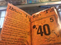
But, being a novice, I need some help regarding the map. I have tried to research the symbols as much as I can, but I get mixed results and I absolutely have little idea what any of this means. I reside in Marion County, Illinois and this is a map of some place in our county where he has hidden the key to a chest.
Any help any one would/could offer would be greatly appreciated.
Thanks!!
 

Attachments

  • 20799821_1422217377815754_366244070937606662_n (1).jpg
    20799821_1422217377815754_366244070937606662_n (1).jpg
    89 KB · Views: 274
Last edited:
Forget about the key...find the chest. Good luck to you:occasion14:
 

We know where the chest is. It is tucked away in a safe at a coin shop. It will not join the key until it is filled. You MUST find the key to get to the chest.
I'm of decent intelligence. The problem is the symbols on the map can mean so many different things. The Tobias cross looking thing: It says to start the map from the longest arm. So if you do that, does southeast become northwest? These are the things as a novice I just do no understand. I think if I knew what the symbols truly meant I could find that key.
 

And this isn't about the treasure anymore. There are more than 2,000 people actively involved the search. It's purely about bragging rights!
 

Howdy Lost,

I would say it is in the Marion town square where you have a bell in the clock tower.

This invention is not a toy, the begining and ending you can see. Seems to me it refers to the old water pump, and the new drinking fountain.

You also have the Southern Bank, or maybe the City Bank where the key fits the treasue box. One may be just forty steps away from where the key is. It could be at the base of the water fountain?

The forty steps may also be up a stairway?
 

Last edited:
The park where the bell tower is at has been run over with people for weeks and no one has been able to find it. He has added some other clues along the way in addition to the map. The shape of the map is a perfect match for Marion County, which has made me think it is in another place. But we have searched to no avail in the places that make sense based on the clues. Again, my biggest issue is the symbols and their meaning. Coazon, I appreciate the help!! And if anyone else has anything to add they think might help, please fire away!!!
 

We know where the chest is. It is tucked away in a safe at a coin shop. It will not join the key until it is filled. You MUST find the key to get to the chest.
I'm of decent intelligence. The problem is the symbols on the map can mean so many different things. The Tobias cross looking thing: It says to start the map from the longest arm. So if you do that, does southeast become northwest? These are the things as a novice I just do no understand. I think if I knew what the symbols truly meant I could find that key.

If any one knew what the symbols mean besides their maker!

You start with/ at water. Map shows a river. Longest arm/ branch of the river?

S.E. corner of map has a cross. Is the cross a church? Or other cross located at a s.e.-n.w. angle to the bell?
40 steps could be stairs?
With no distance scale ,a site/ map item can be well beyond the clock/ village square.
L.o.l..
 

"look to the water...your direction will be"
Which way does the Rio flow if looking at it?
 

"look to the water...your direction will be"
Which way does the Rio flow if looking at it?

Looks like West to East. One of the things we were told is that RIO also can mean a mirror image,like making a mirror image of the map will give you the directions.
 

Looks like West to East. One of the things we were told is that RIO also can mean a mirror image,like making a mirror image of the map will give you the directions.

A birds eye view of another local map should confirm that, if you have two or more symbols correct. (?).
 

A birds eye view of another local map should confirm that, if you have two or more symbols correct. (?).

The black circle means either the number 1 or water, usually a spring. The bell can mean mission or bank. The 40 is a term for distance that can either mean more or less than 40. The number 5 that's up in the right-hand corner? I have no idea at all what it means.
 

The black circle means either the number 1 or water, usually a spring. The bell can mean mission or bank. The 40 is a term for distance that can either mean more or less than 40. The number 5 that's up in the right-hand corner? I have no idea at all what it means.

The 5 is an unknown. Where an orientated map would help come up with ideas. Eliminating doubt one way or another of if a mirror is involved would help look on on actual map of existing site to see what the 5 might be ,( once a feel for scale / distance occurs).

The cross is at an angle ,is it 45 degrees?
Or there is 40 to the 5th power = 102400000. Address? Phone #? Clock hands position,( hey it is similar to angle of cross) Inches,feet,yards,height? Ect..
 

By comparing the map given to a current aerial street map , ( buildings,cemeteries , features and such) what lines up/ fits with map?
If nothing does, what happens when map from book is flipped over to read from the backside?
You have the bell located....if the right bell, and if dark circle is well or water right by the bell and is identified on both maps at proper angles/ directions from each other you have a start.
The cross might be there too ,but what does the cross represent on aerial map? When on most maps it indicates a church or mission. It could be just a cross somewhere... Or an intersection ,but why is it not north south east west type?
 

Last edited:
I wish I had the answers. The cross, according to one book of symbols, indicates you are to start the search at the long arm. If you mirror the map, that takes you from the southeast to the northwest portion of the county, which doesn't add up with the rest of the symbols.
My theory is the key is in the northeast portion of the map at place called Forbes Lake. Other clues have been given and is last one absolutely gives away the fact the key is near water. Like a lake or pond. We have three/four major bodies of water in Marion County.
 

Other clues include: The Book of Revelation will help you with your questions. 2. If you get the key wet it will be easier to find. 3. The key is sheltered from the weather.
 

I am new to hunting for treasure. A gentleman from our area has started having hunts on a regular basis and I can now say I am hooked.
But, being a novice, I need some help regarding the map. I have tried to research the symbols as much as I can, but I get mixed results and I absolutely have little idea what any of this means. I reside in Marion County, Illinois and this is a map of some place in our county where he has hidden the key to a chest.
Any help any one would/could offer would be greatly appreciated.
Thanks!!

"I am the Alpha and the Omega--the beginning and the end[FONT=Roboto, arial, sans-serif]," is from Revelations . Line number 9 from the riddle could be referring to Omega road on the northeast side of the county.[/FONT]
 

"I am the Alpha and the Omega--the beginning and the end[FONT=Roboto, arial, sans-serif]," is from Revelations . Line number 9 from the riddle could be referring to Omega road on the northeast side of the county.[/FONT]

We have scoured the Omega area, most notably Forbes Lake. So many clues took us there but we have come up empty-handed on four trips. I'm about to just throw in the towel. Maybe this treasure stuff just isn't for me.
 

We have scoured the Omega area, most notably Forbes Lake. So many clues took us there but we have come up empty-handed on four trips. I'm about to just throw in the towel. Maybe this treasure stuff just isn't for me.

don't quit now!!!! Just revisit it with a fresh start.
 

Top Member Reactions

Users who are viewing this thread

Back
Top