ThomasJ
Tenderfoot
- Joined
- Apr 5, 2015
- Messages
- 2
- Reaction score
- 0
- Golden Thread
- 0
- Primary Interest:
- All Treasure Hunting
- #1
Thread Owner
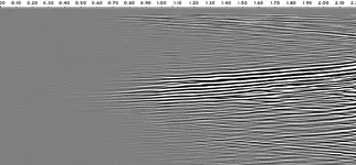
Hello. I would like to know the forum opinion on the below radargram, if it shows a void or not. The numbers above are distance in meters, and the vertical scale is 0 to 30 meters. The profile was created with a MALÅ GX 160 Mhz (range about 16 meters max, before noise). My guess for the soil is packed earth mixed with small rocks. Or pure bedrock.
We scanned as we are looking for archaeological anomalies. We did not just scan at random but information have lead us to this place. We are looking for a "back filled" cavity. I'm not a pro radargram reader, but does it not look like "settled" earth have left a cavity at the roof section of a back filled larger cavity? Maybe water filled? This "cavity" is located at about 10 to 12 meters depth?
I would really appreciate input from people with experience reading radargrams. If not a void, then what is it?


