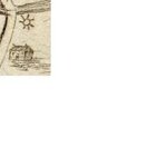
Long time reader, first time poster. Recently I found a 1789 map in the library and it has a symbol on it that I'm not quite sure what it is. Anyone here know what the heck that six pointed star is? The map shows a bridge over a stream. The downward direction on the map is North. There is a homestead just to the north of the bridge and the star is at the northwest corner of the bridge between the homestead and the stream. Any help would be greatly appreciated.
You are using an out of date browser. It may not display this or other websites correctly.
You should upgrade or use an alternative browser.
You should upgrade or use an alternative browser.
New member looking for map advice
- Thread starter NYRanger
- Start date


well the sun is sometimes used to denote gold buried here on a map. However since I know nothing of this map, it's origin, or purpose - I really have no idea.
- Thread starter
- #3
Ocean7 said:well the sun is sometimes used to denote gold buried here on a map. However since I know nothing of this map, it's origin, or purpose - I really have no idea.
No, no. It's not a treasure map. Its a historical colonial map showing a main roadway, bridge, and residence/properties of the wealthy colonial landowners. The spot where the star is had a system of grist, saw, and textile mills for a very short period at the end of the 1800s. They burned shortly after they were built and the owners moved them. That section of bridge and road was the MAIN road until the bridge and road were abandonned and the road straightened. The bridge is no longer there and that area with the star and road are now buried in the woods and pretty much forgotten (except for me
") )
)Rob66
Bronze Member
The only thing I got from that is, time!!!From the look of it.. 4-4:30 PM
RD
RD
- Thread starter
- #6
?dunn1866 said:The only thing I got from that is, time!!!From the look of it.. 4-4:30 PM
RD
 Sorry, I'm at a loss, too, on that one. It sounds like you did your resurch on the area though! Hope you find lot's of goodies.... HH
")

incajoe
Sr. Member
I think it's just the sun. Sometimes map makers included little artist touches to maps back then and I think that they just put the sun shining down on the house as one of these embellishments.
Admiral de Salee
Hero Member
- Apr 2, 2007
- 654
- 19
- Detector(s) used
-
White's V3i w. D2 or Super12
White's DFX w. D2 or 5.3
Sunray DX-1, Lesche Digger
Does look like a mill wheel, though, doesn't it? Mills are something they always had more of than post offices.
Rob66
Bronze Member
The sun is not in the right place...the shadow of the house cast at about 4-4:30.NYRanger said:?dunn1866 said:The only thing I got from that is, time!!!From the look of it.. 4-4:30 PM
RD
The treasure maybe where the shadow is ? Just a quess not seeing all the map.
Postalrevnant
Silver Member
NYRanger I don't have any advice on the map. But I would like to welcome you to the forum. Great group of peps here. Good luck with the hunt, will be looking forward to your finds.
Postalrevnant
Postalrevnant
- Thread starter
- #13
dunn1866 said:The sun is not in the right place...the shadow of the house cast at about 4-4:30.NYRanger said:?dunn1866 said:The only thing I got from that is, time!!!From the look of it.. 4-4:30 PM
RD
The treasure maybe where the shadow is ? Just a quess not seeing all the map.
There isn't anything else on the map. Just this creek, a larger creek this one dumps into and the road. All it is, is one in a series of maps showing the route from one city to another, all the wealthy landowners homes between the cities, and the smaller roads intersecting this main road. This "wheel", or "sun", or marking or whatever it is, is pretty much in the center of the map. It isn't in an upper corner where you would expect an artist to put the sun. A friend of mine told me that he was under the impression that a "star" sometimes would indicate a trading post or a fort...which would be amazing, but the history books have the closest colonial fort about 10 miles from this spot and the closest trading post about 5. I wish the shadow thing were true. Problem is the whole area where this house was sitting is now under an asphalt parking lot...but the road, "wheel", bridge, and spot where there were late 1800s mills is buried in the woods. If anyone has any more ideas let me know. Thanks.
okietreasurehunter
Sr. Member
- Oct 12, 2004
- 378
- 65
- Detector(s) used
- TF 900, Schonstedt, Whites, Garrett, GPR, etc.
What looks to be a sun on a map can indicate a mine or opening. I have seen it used as both out in the field.
SHERMANVILLE ILLINOIS
Gold Member
- May 22, 2005
- 7,205
- 60
- Primary Interest:
- Other
North is up.  ,
,
that is all I know.
have a good un........
SHERMANVILLE
,that is all I know.
have a good un........
SHERMANVILLE
SC_hunter
Bronze Member
- Jan 16, 2007
- 2,410
- 160
- Detector(s) used
- Whites V3i,Whites XLT,Ace 250 and BH Tracker IV and Others.....
- Primary Interest:
- All Treasure Hunting
EDDE
Gold Member
- Dec 7, 2004
- 7,129
- 65
- Detector(s) used
- Troy X5
- Primary Interest:
- All Treasure Hunting
pleasestilldign said:Your six-pointed star is a tunnel symbol. This tunnel is located near a water-way.
Figure out where to fold this coded map and you'll get the true location of this tunnel.
Remember, if, in the folding of this map any symbols lie "in the water," then you need to reverse the map for that part of the instructions.
Top Member Reactions
-
 1961
1961 -
 1186
1186 -
 1137
1137 -
 1019
1019 -
 954
954 -
 936
936 -
 869
869 -
 804
804 -
 794
794 -
 781
781 -
 476
476 -
 457
457 -
 412
412 -
E
358
-
 344
344 -
 321
321 -
 318
318 -
 298
298 -
 285
285 -
 281
281
Users who are viewing this thread
Total: 2 (members: 0, guests: 2)

