Mark Wright
Jr. Member
I have no desire to hide my discoveries even if it leads to nowhere. Someone might find something useful. I've been told that I need to keep my posts short, so I'll try to do that.
This is conjecture, Fantasy, etc., Please do not use this information in the real world. Do not go onto private property. (12 million people live within an hour's drive.)
Four pointers indicate that the Oak Island question is answered in the US. I stand by my previous thread because, even considering the "debunked" Zena documents, her products led me to this and other discoveries.
Four Degrees:
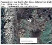
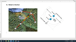
The Boat Stone was found in 1932(?) during the construction of a highway near Westford, Mass. Carved into the stone is an old sailing ship, an arrow and the number 184. Using that number, I discovered that an azimuth of 184 degrees from a boulder on the north beach reveals a pointer to the South Beach Corner stone. I then applied the same process from a point in Westford, Ma. with similar results. The big difference is that Oak Island distances are measured in feet while Westford's are in miles.
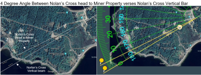
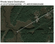
The "Four" degrees appeared to help locate points of interest, so I applied it to Oak Island. I added 4 degrees north to the angle of the 867-foot body of Nolan's Cross. Using Google Maps, I extended both lines all the way to the US. The 4-degree line intersected the Boat Stone line in Rhode Island while the Nolan's Cross line went out to sea.
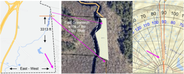
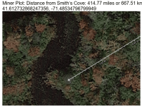
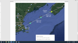
I researched the property where the lines intersected and discovered a small, oddly shaped (.75 acres), isolated, piece of land that is in the middle of a swamp. A river that empties into the ocean is the west boundary. Looking at the property boundaries, I noticed that the line between East Greenwich and North Kingstown was at an odd angle, a 4-degree angle. Why did the deciding officials go approximately 250 feet past a perfectly reasonable vertical straight line in favor of a line that tilts west 4 degrees?
Is it a coincidence that:
I find it interesting that the name of the deceased owner of the property was “Miner”. Does a “miner” mean that there’s a mine.
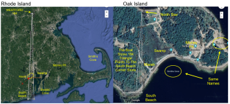
Does Rhode Island's shape resemble Oak Islands?
This is conjecture, Fantasy, etc., Please do not use this information in the real world. Do not go onto private property. (12 million people live within an hour's drive.)
Four pointers indicate that the Oak Island question is answered in the US. I stand by my previous thread because, even considering the "debunked" Zena documents, her products led me to this and other discoveries.
Four Degrees:
The Boat Stone was found in 1932(?) during the construction of a highway near Westford, Mass. Carved into the stone is an old sailing ship, an arrow and the number 184. Using that number, I discovered that an azimuth of 184 degrees from a boulder on the north beach reveals a pointer to the South Beach Corner stone. I then applied the same process from a point in Westford, Ma. with similar results. The big difference is that Oak Island distances are measured in feet while Westford's are in miles.
The "Four" degrees appeared to help locate points of interest, so I applied it to Oak Island. I added 4 degrees north to the angle of the 867-foot body of Nolan's Cross. Using Google Maps, I extended both lines all the way to the US. The 4-degree line intersected the Boat Stone line in Rhode Island while the Nolan's Cross line went out to sea.
I researched the property where the lines intersected and discovered a small, oddly shaped (.75 acres), isolated, piece of land that is in the middle of a swamp. A river that empties into the ocean is the west boundary. Looking at the property boundaries, I noticed that the line between East Greenwich and North Kingstown was at an odd angle, a 4-degree angle. Why did the deciding officials go approximately 250 feet past a perfectly reasonable vertical straight line in favor of a line that tilts west 4 degrees?
Is it a coincidence that:
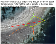
- the Boat Stone uses 4 degrees west of south to point at the Road Island Miner property from the north,
- the Boat Stone uses 4 degrees west of south to point at the Oak Island South Beach Corner Stone from the north,
- the southeast corner of East Greenwich metropolitan area has a 356-degree angle (4-degrees west of north) that points at the “Miner” property from the south,
- the angle between Nolan’s Cross head to the Rhode Island “Miner” property and Nolan’s Cross Vertical Bar is 4 degrees?
- Does the intersection of the Boat Stone azimuth and the Oak Island azimuth mean that the “X” marks the spot.
I find it interesting that the name of the deceased owner of the property was “Miner”. Does a “miner” mean that there’s a mine.
Does Rhode Island's shape resemble Oak Islands?