Pic #2 is taken at Tom Steed Reservoir, in Great Plains State Park in Kiowa County, about 4 miles north of Mt. Park. I lived there for about a year in 70, just almost in the middle of the right of the photo. No lake there then. Lots and lots of history there. The final Camp Radziminski was located about 2 miles south of this pic. Gold Belles mine and cyanide mill, and the mining town of Wildman are about 3 miles north. For treasure tales, you can't beat it. The narrows on Otter Creek with the old crossing are south of the pic, and Twin Mountains are about 3 miles west. The old Spanish road along the north fork of the Red river is southwest, and Devil's Canyon is straight west. This area is in the Wichita Mountain range and there's so much history and tall tales about this place that I can't even begin to tell you all of it, and even I don't yet know all of it. But it is Oklahoma, and Oklahoma can look pretty sometimes.


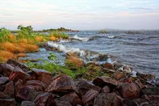


 . Pic 2 is beautiful