You are using an out of date browser. It may not display this or other websites correctly.
You should upgrade or use an alternative browser.
You should upgrade or use an alternative browser.
Old Hand Dug Holes Found And What Took Me There
- Thread starter dsty
- Start date


dsty
Bronze Member
- #62
Thread Owner
Here's a notch that I thought I had lost, the two fighting fish had V's for a mouth but they were faceing each other. This is the feature of a triangle, three corners, Those of you that have a square cut into a side of a rock may look for four corners, square, possibly a rectangle.
Attachments
![Doolin001[1].webp](/data/attachments/419/419218-cdcee1dbec7f0c964354cc7a3c915bc6.jpg?hash=76b71BurqN)
dsty
Bronze Member
- #63
Thread Owner
This the size stone that the map was carved on notice its gone, the person that removed it broke it up, he has since passed. Another valued piece of history gone forever. note the size about forty inches L- X 16 inches wide and 16 inches high, sharp point rounded end. It was upside down, and needed 2 strong men to turn it over.
Attachments
![DSC07764[1].webp](/data/attachments/419/419225-04fa27c50e0e3ecfa82863831fde52ba.jpg?hash=DRKlVMQ4WT)
dsty
Bronze Member
- #64
Thread Owner
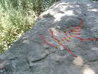
Thank You Lost Horse for allowing me to post and write all over it, your post off your site, your Idea that it is a sluice box used to collect gold is very likely but I wonder if its a map showing a Royal Trail also, with monuments ( symbols ) that spur off to the sides,a symbol showing upstream and turn right / left to the Mines or Caches, the dots follow the trail up stream, the turtle head is going down stream which to follow it to mines or caches would be to travel up stream, it would be interesting to see if it has a tail, although it does have a body, ( indicating travel both ways ), anyway my thoughts are that its possibly both, this is a sluice box and a map . Thanks Lost Horse for allowing me share my thoughts
Attachments
dsty
Bronze Member
- #65
Thread Owner
Thoughts on drill holes have been on my mind a lot lately, those that are golf ball size up shallow and round bottom ( and will usually have a carving in the bottom ) including softball size indicates that measurements will be by the foot, the one that are most important ( one corner of triangle ? square, note here that all patterns that I have seen are of triangles ) are on a angle and have a narrow bottom, do not discount the dots that form around the edge, Most that I have seen are measured either by the foot or pace, 33 inch, they use cordell lots and fractions of cordell, relatively easy to follow no need to measure just a regular 30/33 inch pace will get you where you need to be, I sometimes use 1/4 of a white bed sheet and place it above the carving and use it as a reference when I look back
dsty
Bronze Member
- #66
Thread Owner
Thanks for your reply and your drill hole photo, I would encourage anyone that has photos of drill holes to post them if you would like, they are everywhere and so far the triangles and drill holes are the most common things that's found in my neck of the woods. I suppose that this is the best place for me to mention this. This is something that you will find that's common with everything I have seen, at the Start of a trail you will find a map, near a River bend, or someother eye catcher, hill off by its self, forks of a stream, mouth of a stream, canyon, you should find the carvings, more than likely a series of dots, drill holes that shows the main trail and all the information you will need as to how many, direction, all the info you will need to locate that what you seek, it could be water, building stone, cement, clay or caches with more interesting matter, there are maps and you should look for them, the smallest that I have seen was about 3 inches long and 2 inches wide, a series of 6 dots about the size of the white ( striker ) end of a kitchen match that showed the turns and number of drill holes used to mark the trail, the map its self resembled the little dipper like you would see in the heavens. I wish to say to all of you that I appreciate the notes you send, right now there's not much time to respond, I save them and yes I will respond, THANK'S
dsty
Bronze Member
- #67
Thread Owner
More should be said about the corner symbols that you find and the pattern you should expect, The rock that had the map carved on the bottom ( size 6" X 6" ) information on it, horse shoe / tunnel symbol and a date of 1814 representing the depth AND the corner of the triangle where you should look for the cache, on the ground the map formed the 1st corner,at 30 degrees and 95 feet went to the 4" X 4" drill hole on the bluff formed the 2nd corner, from that corner go 330 degrees and find a 8" wide X 4" deep drill hole at 1 cordell with a block cut out about 1/2 way down creating a shoulder, reading the two 3 mm dots that's 3cm deep that's on the same rock and direction shows 330 degrees, distance information is on the 8" drill hole 8" X 4"= 2 X 69 ( cordell ) and the shoulder 1/2 way down = 1/2 cordell or 2.5 cordell = 172.5 paces or 172.5 X 33 = 5692.5 inches divide by 12 = 474.375 feet, I measured using a 100 foot plastic coated clothes line that I could drag thru the brush and got 485 feet that got me close enough to start looking around and found the drill hole with the angled hole with the rounded bottom, from that hole it was 95 feet measured, 1/2 Cordell = 94.75 feet that was the photo of the drill hole on the Rabbit head photo,sharp sides 1 inch across the bottom which was as the Viking mooring holes used to anchor their ship on a angle and about 10 inches deep, also 95 feet long is one of their ships length. Altho yours may be different I feel that there will be a pattern that you will find. Find a triangle layed out on the ground with the three corners, measure and retain all the information get degrees, look around always for monuments, be certain that there will be fish, armadillo, lambs,knee high rocks that form a upside down V, anything like that catches your eye has done its job, The monument that helped most was the rabbit showed me, top and where you can see in all directions. Good Luck and be safe
oddrock
Hero Member
- Joined
- Apr 7, 2010
- Messages
- 560
- Reaction score
- 86
- Golden Thread
- 0
- Detector(s) used
- Garrett , Minelab ,White's, others and B.S. sniffer
Dsty,
Just tought I would add a double pointer rock from one of my trails. Does the two big notches on the edge have the same meaning as drill holes? (they are about 1/2 of a drill hole, each about four inches at the widest).....or maybe 1/2 the distance....
Oddrock
Just tought I would add a double pointer rock from one of my trails. Does the two big notches on the edge have the same meaning as drill holes? (they are about 1/2 of a drill hole, each about four inches at the widest).....or maybe 1/2 the distance....
Oddrock
Attachments
dsty
Bronze Member
- #69
Thread Owner
Stilldiggin's post I guess I missed it, The Jesuit Priest ( along with others that contributed ) is attributed to, in my opinion several thousands of cache sites, they were a very well learned group, very serious, they were very well versed in reading symbols of the Spanish Priest, If I have my history right the Jesuit priest joined the Knight Templar group in the middle of the 1400's, for protection, then perhaps ( this is just theory, because of the Mooring holes, ship length, cargo holes location ) the vikings were a part of their group, as were possibly others, regardless of who it was they had to have certain patterns to use, for instance if there was a trail and you just got lucky and figured out that a head of something was a just one direction, follow the head, if it had a body then the trail could be followed both ways, which if you just wandered around and found a trail marker which way would you go, the marker knows, you would be able to follow both directions,( That's one Pattern ) the use of triangles I don't think they can be disputed they do exist, they will be the same, three corner's that form a triangle ( pattern number two ) then it stand to reason that why would they show you a triangle and on one corner they placed a dig here carving, perhaps a ORO , or some other symbol that represents gold such as a drill hole with a dot or a small drill hole in the center, representing a O with a dot, another dig here symbol and believe me there's lots of them, however the one you found so easy using 3 carvings, is not the real one, away from that will be perhaps you will find two carvings in a row with a trail does not go anywhere, so you kick the ground spit ( unless you are a girl ) go back to the car and figure that another one lost, go back to the triangle that has the three corners, look for a symbol that represents gold or something different, a round rock in the middle, it can be outside the line, on the line, 50 feet away from a corner, get ALL the measurements for this is the map that will show you where the cache is at, using the two symbols that don't go anywhere and the information found at the known triangle you will be able to find what you seek, BIT has one on the and at the River, I think they are too far apart ( may be two ) but they may go together, also something on one of the corners will give the direction to go and the distance, using two triangles and method of placement of the corners, The corners can be made up of any number of things, white rocks, drill holes, anything that does not fit, look for eye catchers large and small ( figure patterns ) information they contain should increase your odds of finding something. My finger is tired, hope this helps
dsty
Bronze Member
- #70
Thread Owner
Good Grief, seems that Twisted Fork has a site that's devoted to the same thing, "Spanish Clock Map" seems that they may have used the pattern for cache sites also. Windrose woke me up, using variations of the same pattern could help find old hand dug holes, or better than that no old hand dug hole. Thanks
Old Dog
Gold Member
bump this back to the top.
dsty
Bronze Member
- #72
Thread Owner
Thank you Thom for the bump, This will be my thoughts and please don't think harsh of me, Our country, our states are made up of one mile sections so far everyone probably is in agreement because thats the way it is you can see them on county maps. Things were kinda like that in New Spain except their mile was a leauge or 2.5 miles, as Oklahoma had their land run with each person having an alloted parcial of land for their Claim, homestead. My thoughts are that New Spain had the same thing except theirs was bigger and contained a Hope Chest ( cache ), you see trail markers that indicate both ways, a Cross = four directions, turkey track, four directions, four, five, six directons off of drill holes, ( you have neighbors this way ) A lot of the symbols, monuments, have at least two directions that can be followed. There's a cross on Red River that has a broken arm, ahead to the trail, watch on the right hand side 100 paces cache site, cross was 10 inches long 25 CM ahead 1 league, long part of the cross reverse 25 CM 1 league. It has been my experience that they would use 3/4--- 1/2 ---- 1/4 of whatever they were using, League / Cordell. Using the League, it is 69 cordell's long and could represent a League square, or a Spanish Section. There should be corner markers at each section, if the cache is in the middle of all them, or at each corner, or somewhere else inside the league square. . I just started thinking outside the box, don't mean to offend anyone ,
dsty
Bronze Member
- #73
Thread Owner
When you find 4 dots with a 3mm drill hole on a rock and theres 4 corners layed out in a pattern on the ground, but it may be that you need to find the league square and do your measuring from. I think that the corners would all be the same for instance a stone in the ground with a upside down shape-- V--they all seem to be the same shape and size. It could be that they are corner markers.
dsty
Bronze Member
- #74
Thread Owner
In order to explain my thoughts about corner markers at each corner of the League square thought, I have seen several triangle shaped rocks sticking out / sitting on top out of the ground and not given much thought to any of them, however if you know of one I think that the easiest way to see if they are corner markers would be to check the compass degrees, do the sides run North and South / East and West, if they all fit that pattern then further investigation such as the degrees 360/ 30 and distance 2.5 miles could be checked, with a GPS / county map it should be easy, this kinda stuff needs to be a group effort and seems that everyone would benefit from the information. Thanks Everyone, Lost Horse has some , Desert Moons has some, each person in this class room has something to offer, I plan to get the info on the one off my site, its buried deep in the ground and approx 30 inches high, it will take me a couple of days, looking forward to working with everyone.
Shortstack
Silver Member
- Joined
- Jan 22, 2007
- Messages
- 4,305
- Reaction score
- 419
- Golden Thread
- 0
- Detector(s) used
- Tesoro Bandido II and DeLeon. also a Detector Pro Headhunter Diver, and a Garrett BFO called The Hunter & a Garrett Ace 250.
- Primary Interest:
- All Treasure Hunting
Dsty:
About those triangle stones. Could they be cut accurate enough to represent the "4, 5, 6" rule for getting the true right angle of the corners of their plots of land? That's probably a silly question, but when I think of how you field folks have found and followed headings that include fractions of degrees (example 33 and 1/3rd) then my curiosity pops up that "accurate right angle" question.
LOL, sometimes my questions probably get too in depth. Old Dog calls it "looking at clouds".
Old Dog
Gold Member
LOL, sometimes my questions probably get too in depth. Old Dog calls it "looking at clouds".
The questions aren't what I call cloud watching, I have said many times "the only stupid question is the one you don't ask"
Old Dog
Gold Member
Dsty,
In my gear I carry a regular 100 foot tape, a 12 inch, a 6 inch rulers. a brass protractor and a vara stick marked in Castillian inches.
with these... everything seems to fall into place.
In my gear I carry a regular 100 foot tape, a 12 inch, a 6 inch rulers. a brass protractor and a vara stick marked in Castillian inches.
with these... everything seems to fall into place.
dsty
Bronze Member
- #79
Thread Owner
Good Morning Thom, To speak more about the triangle rocks sticking out of the ground and the possibilities of them being corner markers, in my attempt to learn more the height is important as the angles found along the sides and ends, for that you need a protractor level ( about $10.00, Staples/Wal-Mart/ Lowes ) , it may indicate a 30 degree slope and therefore, May indicate the compass degrees of 30 degrees, them folks were crafty critters or that's just the world they lived in. Anyone that has not read Desert Moons / Lost Horse and LOTS of others.They take you on a trip Thur their travels and you can see things like a triangle rock sticking out of the ground, a huge elephant, large boulders in the shape of a snake, what do they mean, what purpose do they serve, I have 5 fish on my site, they have a purpose if nothing more than to identify the site, an elephant, turtle, snake. Go this way find a 6 foot long fish that points to the west, that square league belongs to you ( I told you I need to be in a rubber room ), why are some symbols sticking into the ground on an angle, why does a bear head look at the ground less than a foot in front of its nose, ? angle, protractor level shows a 90 degree angle what direction should I go, look for a bear head, profile, footprint, den, how far should I go.
Old Dog
Gold Member
Ernie,
in several places we found where they tried to establish a settlement. at each site somewhere high above the site and usually on the Northern side we found a flat rock carved as a map of the settlement.
These We believe helped establish boundaries as well. At each site when standing at the map stone, you have a full view of the entire area that they were working with.
Any work they did is still evident... fortifications and road work monuments and things most people ignore, are there as if they had been put out yesterday.
Top Member Reactions
-
 2334
2334 -
 1460
1460 -
 1419
1419 -
 1347
1347 -
 1089
1089 -
 995
995 -
 868
868 -
 851
851 -
 697
697 -
 596
596 -
 579
579 -
 560
560 -
 528
528 -
 485
485 -
 470
470
Similar threads
- Question
- Replies
- 9
- Views
- 278
Users who are viewing this thread
Total: 1 (members: 0, guests: 1)
