Old photo

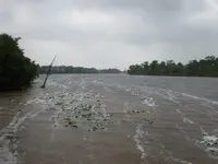
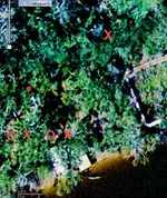
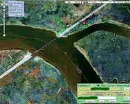
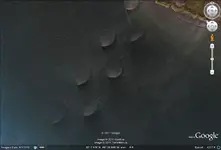
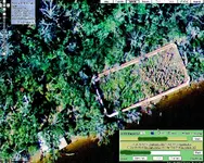
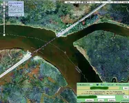
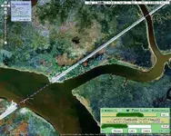
Aerial view of the place. Dowsers probably may get some hits opposite the river mouth too.

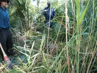
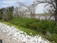
Once there was a pirate ship, all loaded down heavy with treasure. For some reason, the pirates were able to bring the ship up to the Pearl river. It could have been during a time of flooding, such as it was this year...or perhaps enough treasure was cached first, so that the ship might be scuttled to avoid capture. A bayou off the Pearl river is the site where pirates abandoned their ship.
 

Attachments

  • Baldwin,Lodge03.webp
    Baldwin,Lodge03.webp
    197.3 KB · Views: 348
  • Baldwin,Lodge02.webp
    Baldwin,Lodge02.webp
    271.4 KB · Views: 341
  • Baldwin,Lodge01.webp
    Baldwin,Lodge01.webp
    283.9 KB · Views: 346
A story about Calico Dick, holds the as they were being chased, booty was off loaded and the boat scuttled in a off shoot bayou. They were all captured and hanged. Thanks Red. LT
 

I picked up some gold and silver pirate type of caches, outside the river mouth. There are multiple caches close together. :coffee2:
 

Makes sense as it was a landmark. With history back to LaSalle, no telling what went on there. The trail was known as Black Wolf Trail by the Indians for ages. Then the French, then the Spanish, then pirates, outlaws, confederates, the works.
 

Nice pictures along with nice History of the area. Loved that type of Aerial Map. :D
Also just wanted to say that with this dowsing we get a chance to visit other areas and learn a great deal of history that we normally wouldn't have read other wise.
Thanks fenixdigger for the updated pictures. :thumbsup: 
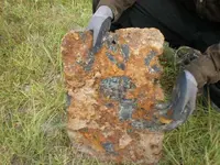
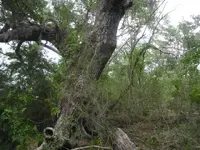
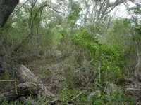
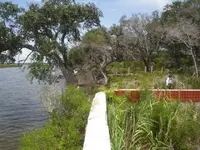
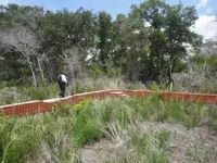
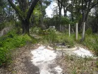
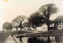
That place sure has changed.
Joy
 

That's not the spot, just an area a few miles North of it. The place is all about the same. Most places we have to hack a spot to even land the boat. The insects are an amazing bunch, I think some are carrying switch blades. This is the place you don't want to be at night.

The mosquitoes have been known to breed with Blue-jays and small hawks there. I'll post some photos of random shots. One of a marker tree is pretty cool.
 

Attachments

  • PIC_0392.webp
    PIC_0392.webp
    72.5 KB · Views: 304
  • PIC_0392.webp
    PIC_0392.webp
    72.5 KB · Views: 291
Oh. The camera was not fogged and It was not the sun(I always shield the camera) and I did not see this when I took the picture with a digital camera. Here's a few more.
 

Attachments

  • P5270105.webp
    P5270105.webp
    79.3 KB · Views: 305
  • P5260097.webp
    P5260097.webp
    68.8 KB · Views: 308
  • P4260065.webp
    P4260065.webp
    43.1 KB · Views: 273
  • P4270070.webp
    P4270070.webp
    27.5 KB · Views: 302
  • P5260097.webp
    P5260097.webp
    68.8 KB · Views: 291
  • P5270105.webp
    P5270105.webp
    79.3 KB · Views: 309
It is all very interesting...might as well post my results for Baldwin Lodge in the aerial. Found 2 more caches, circles for markers, fenixdigger already has this photo.
 

Attachments

  • Baldwin,Lodge4crop.webp
    Baldwin,Lodge4crop.webp
    126.1 KB · Views: 304
fenixdigger,
Here is my dowse using the aerial you posted.
The dowsing revealed gold/silver coins in the area of the green circles.
Thanks for posting your pictures,
Jon
 

Attachments

  • Baldwin,Lodge02dowsed.webp
    Baldwin,Lodge02dowsed.webp
    249.3 KB · Views: 298
Thanks to all for the help. I'll retake the old photo from the same spot and some around the area. LT
 

Well, we're back. A heck of a run. There is news. We were a year or so late. I stopped counting when I got to 30 holes.

Crazy as it sounds, they were EXACTLY where you guys picked. Where the cache was marked, an area 8 ft across was dug up.

The G.E. photos were taken before Katrina 2005 because the place is tore up. We have some photos of what's left and I tried to retake

the original, but the wall was tore up. I am waiting on my copys and will post them as soon as I get them. We used someone else's

camera and my computer won't read the card. It was cool knowing we were standing where Al Capone and who knows else once were.

The photos will be my last post. There are some people ( idiots?) here that Will get you in trouble and laugh about it. Best to stop

before corrective action is required.


Thank's to all and it's been a hoot. I hope I was able to help some of you out, I know I got a lot of help from you. I'll put a little

something extra in with the photos. A spot that I am for sure going to dive on to see for myself.
 

Here's the first 3. Old Spanish oak was huge. One shows the brush you face in most of the area. Gives you an idea there was no wild

coil swinging going on without having an idea where to clear. The other was taken from the NNW corner from the RR tracks. More to

follow.
 

Attachments

  • baldw1.webp
    baldw1.webp
    59.5 KB · Views: 252
  • baldw2.webp
    baldw2.webp
    64.2 KB · Views: 235
  • baldw3.webp
    baldw3.webp
    52 KB · Views: 233
Here's the little something else. This is not shown on nautical maps and I have never heard anything about this. These continue 4 1/2 miles

SSW to another Island. There is nothing on either end. The lines are appx. 500 ft apart, and run straight across a small isle. I will get wet

to see these.
 

Attachments

  • stranger.webp
    stranger.webp
    49.2 KB · Views: 245
  • strange.webp
    strange.webp
    98.9 KB · Views: 233
fenixdigger said:
Well, we're back. A heck of a run. There is news. We were a year or so late. I stopped counting when I got to 30 holes.

Crazy as it sounds, they were EXACTLY where you guys picked. Where the cache was marked, an area 8 ft across was dug up.

The G.E. photos were taken before Katrina 2005 because the place is tore up. We have some photos of what's left and I tried to retake

the original, but the wall was tore up. I am waiting on my copys and will post them as soon as I get them. We used someone else's

camera and my computer won't read the card. It was cool knowing we were standing where Al Capone and who knows else once were.

The photos will be my last post. There are some people ( idiots?) here that Will get you in trouble and laugh about it. Best to stop

before corrective action is required.


Thank's to all and it's been a hoot. I hope I was able to help some of you out, I know I got a lot of help from you. I'll put a little

something extra in with the photos. A spot that I am for sure going to dive on to see for myself.

Yeah, I was wondering what you'd find there...recently did some dowsing work for a treasure hunter of carved marked rock, trees to find where the caches were buried. I found the exact spot for a marked stone, problem was a trench shaped hole dug until they hit the cache. You can still see the outline from the chest in the bottom of the corner...think my depth estimation was accurate too. At least dowsing can solve the mystery of marked trees and rocks, even when caches have already been recovered...if the hole is still there.
 

I might add, in a situation like that, they could have missed a cache or not bothered because of tree roots from a big tree in their way.
 

fenixdigger said:
Here's an old photo of a place we hunt.


*

Here's the now.
 

Attachments

  • Baldwin Lodge, on the Mouth of the Pearl River at the L&N track, Hancock County.webp
    Baldwin Lodge, on the Mouth of the Pearl River at the L&N track, Hancock County.webp
    45.7 KB · Views: 232
  • bldwn4.webp
    bldwn4.webp
    59.8 KB · Views: 255
  • bldwd3.webp
    bldwd3.webp
    62.2 KB · Views: 227
  • bldwn5.webp
    bldwn5.webp
    64.4 KB · Views: 232
  • Baldwin Lodge, on the Mouth of the Pearl River at the L&N track, Hancock County.webp
    Baldwin Lodge, on the Mouth of the Pearl River at the L&N track, Hancock County.webp
    45.7 KB · Views: 229
Wow! What a change. Time sure has taken alot away and added alot also! What a differance! :o
 

fenixdigger said:
Here's the little something else. This is not shown on nautical maps and I have never heard anything about this. These continue 4 1/2 miles

SSW to another Island. There is nothing on either end. The lines are appx. 500 ft apart, and run straight across a small isle. I will get wet

to see these.
those look odd from the view, if you move up the map you will see many more around the shoreline. looks like oil booms or skimmers in the water.
 

Top Member Reactions

Users who are viewing this thread

Back
Top Bottom