Clay Lindsey
Full Member
Jayheazy,
There is an outstanding amount of good information posted here. Because I am "newer" at this than most, I will offer up my current working strategy for solving these types of signs/symbols. Because the meanings of the signs/symbols used was left up to the person who made them, the traditional definiton may get you close, but not exact.
So what I have done in order to "best guess" what the person was trying to communicate on my sites was the following:
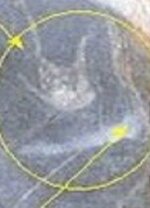
1) As accurately as you can, date the site.
2) Plot all of these points on a map
3) Using the corrected declination for the time period, layout azimuths from these plotted points.
4) Where the lines cross, take note, and inspect the area on the ground for more signs.
Using the above method has taken me to two different trails (one in, one out), linking two different sites about a mile away from each other. It's a lot of "boots on the ground", but hard work equals eventual success.
Clay
There is an outstanding amount of good information posted here. Because I am "newer" at this than most, I will offer up my current working strategy for solving these types of signs/symbols. Because the meanings of the signs/symbols used was left up to the person who made them, the traditional definiton may get you close, but not exact.
So what I have done in order to "best guess" what the person was trying to communicate on my sites was the following:
1) As accurately as you can, date the site.
2) Plot all of these points on a map
3) Using the corrected declination for the time period, layout azimuths from these plotted points.
4) Where the lines cross, take note, and inspect the area on the ground for more signs.
Using the above method has taken me to two different trails (one in, one out), linking two different sites about a mile away from each other. It's a lot of "boots on the ground", but hard work equals eventual success.
Clay


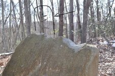
 ?? What is he looking at