8KCAB
Guest
- Joined
- Jul 12, 2011
- Messages
- 22
- Reaction score
- 11
- Golden Thread
- 0
- Location
- Bakersfield
- Detector(s) used
- Tesoro Vaquero
- Primary Interest:
- All Treasure Hunting
- #1
Thread Owner
Howdy, all.
I'm planning my first real expedition. I'm going explore around Robber's Roost near Inyokern. It's only an hour or two from where I live, and I wanted to get out in the Mojave. I just kind of picked is based on information in the "United States Treasure Atlas, Volume 2" by Thomas P. Terry on pages 154 and 155. It seems that it has probably been explored pretty well, and I really do not have a cache hunting detector, but I just want to get out there.
I use the Kern County Geographic Information System (http://www.co.kern.ca.us/gis/) and Google Earth to check it out. I can use the APN's off the GIS to get parcel ownership information from a title company website - to check for private property. Things look OK so far, (many parcel owners listed as "USA" - federal land) but I'm a little worried that it is near the California Aquaduct, with property being owned by L.A. County. It's listed as public, but I'm thinking there may be some heartburn about operating near a water supply.
Anyway's, I was wondering if anybody had any info on the area. I am especially interested on any precise info related to the location of the Freeman Junction stage station - or just general tips on what to look for when determining where ruins may have once stood in the desert.
From "United States Treasure Atlas, Volume 2" by Thomas P. Terry p.154-155:
"Freeman S. Raymond operated the Freeman Junction stage station, bar and rest stop SW of today's location of Freeman Junction... It was believed by his relatives and friends that he buried a considerable amount of gold coins... The hoard is probably in the area of the spring in the wash just below the site of his stage station..."
Any info/advice is appreciated!
***UPDATE EDIT***
Found some more good info here: http://wikimapia.org/country/USA/California/Indian_Wells/
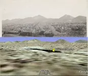
***ANOTHER UPDATE***
Let me know how you think these two skylines match up:
I'm planning my first real expedition. I'm going explore around Robber's Roost near Inyokern. It's only an hour or two from where I live, and I wanted to get out in the Mojave. I just kind of picked is based on information in the "United States Treasure Atlas, Volume 2" by Thomas P. Terry on pages 154 and 155. It seems that it has probably been explored pretty well, and I really do not have a cache hunting detector, but I just want to get out there.
I use the Kern County Geographic Information System (http://www.co.kern.ca.us/gis/) and Google Earth to check it out. I can use the APN's off the GIS to get parcel ownership information from a title company website - to check for private property. Things look OK so far, (many parcel owners listed as "USA" - federal land) but I'm a little worried that it is near the California Aquaduct, with property being owned by L.A. County. It's listed as public, but I'm thinking there may be some heartburn about operating near a water supply.
Anyway's, I was wondering if anybody had any info on the area. I am especially interested on any precise info related to the location of the Freeman Junction stage station - or just general tips on what to look for when determining where ruins may have once stood in the desert.
From "United States Treasure Atlas, Volume 2" by Thomas P. Terry p.154-155:
"Freeman S. Raymond operated the Freeman Junction stage station, bar and rest stop SW of today's location of Freeman Junction... It was believed by his relatives and friends that he buried a considerable amount of gold coins... The hoard is probably in the area of the spring in the wash just below the site of his stage station..."
Any info/advice is appreciated!
***UPDATE EDIT***
Found some more good info here: http://wikimapia.org/country/USA/California/Indian_Wells/
***ANOTHER UPDATE***
Let me know how you think these two skylines match up:


 a lot of color around the Jawbone Canyon area back in the '50's-60's. The family has maintained homes in the Randsburg area going back over 60yrs, until 3 yrs. ago when the last one got too old to be alone out there.