You are using an out of date browser. It may not display this or other websites correctly.
You should upgrade or use an alternative browser.
You should upgrade or use an alternative browser.
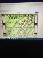
Question about Historic Aerials?
- Thread starter Truth
- Start date
Charlie P. (NY)
Gold Member
- Joined
- Feb 3, 2006
- Messages
- 13,021
- Reaction score
- 17,188
- Golden Thread
- 0
- Detector(s) used
- Minelab Musketeer Advantage Pro w/8" & 10" DD coils/Fisher F75se(Upgraded to LTD2) w/11" DD, 6.5" concentric & 9.5" NEL Sharpshooter DD coils/Sunray FX-1 Probe & F-Point/Black Widows/Rattler headphone
- Primary Interest:
- Metal Detecting
Can you navigate on the map to a corner where there is a map key?
USMC Reaper
Hero Member
- Joined
- May 23, 2015
- Messages
- 672
- Reaction score
- 982
- Golden Thread
- 0
- Location
- Abbeville, S.C.
- Detector(s) used
- MineLab CTX 3030, Equinox 800
- Primary Interest:
- Metal Detecting
That is a boundary/border of some type. Municipality/city/county maybe
bigscoop
Gold Member
- Joined
- Jun 4, 2010
- Messages
- 13,541
- Reaction score
- 9,086
- Golden Thread
- 0
- Location
- Wherever there be treasure!
- Detector(s) used
- Older blue Excal with full mods, Equinox 800.
- Primary Interest:
- All Treasure Hunting
First, you do realize that's not an aerial map, yes? Quality aerial images for most of the country won't even date too far back, the technology not really being up to snuff until the last 20 years or so, those that do date further back generally lack visibility and detail, the resolution so poor built in zoom features are of little use. Also, a lot of the aerial image sites will often substitute the type of general maps you show in your post for all the above reasons.
TN/SC
Jr. Member
I found some 1938 aerials of my area, not great detail but.
Aerial Photograph Index, Jasper County (S.C.), 1938 :: South Carolina Aerial Photograph Indexes, 1937-1989
HH
Aerial Photograph Index, Jasper County (S.C.), 1938 :: South Carolina Aerial Photograph Indexes, 1937-1989
HH
Similar threads
- Replies
- 5
- Views
- 744
Users who are viewing this thread
Total: 1 (members: 0, guests: 1)


