Hello,
Here is a link to the first article. Didn't see it anywhere earlier:
http://news.mywebpal.com/news_tool_v2.cfm?pnpid=680&show=archivedetails&ArchiveID=1157197&om=1
As to what I do and why ( I didn't want to bother anyone with the details, but since you asked
")
):
It's true, I'm not getting a PhD in remote sensing as such. I'm a Geology PhD candidate with an emphasis in Geoarchaeology at the Univ. of Georgia. My project is studying Roman lead Curse Tablets from Carthage, Tunisia using Thermal Ionization Mass Spec. However, as part of my training, I also work in remote sensing.
The most expensive and time consuming thing any archaeologist can do is excavate a site. Among other things, geoarchaeologists try to locate areas of potential archaeological interest without digging. This is remote sensing and we use many of the techniques used by geologists. More traditional archaeologist don't want to spend the money and time learning how to run specialized instruments and learning how to read the results. Think of them as the general public when they lose a wedding ring. Most won't go buy an expensive metal detector and then learn to use it just to find the ring. They would much rather just call me to find it for them. Thus, I have the opportunity to travel anywhere in the world and work on site of all time periods. And, there are academic and contract positions for someone with my training.
We use the following most heavily:
Ground Penetrating Radar
Ground penetrating radar is an active method of remote sensing that uses microwave transmissions to image the subsurface. The microwaves are transmitted and received by an antenna that then sends this information to a control unit. The image is created by the difference in the ways that soils and materials conduct the microwaves. When the microwaves leave the antenna, they pass into the ground, where their paths are affected by the different materials present under the surface. Some of the microwaves will be bounced off of an object or change in soil composition, and others will simply pass through and dissipate. When the microwaves encounter a material, such as a buried wall, the depth of the wall will change the amount of time needed for the microwaves to travel into the ground and bounce back to the receiver on the antenna. All of these effects are used to create a vertical image of the subsurface, which is then processed into horizontal plan view maps based on depth.
A map of a site, looking down from above, can be made at any depth desired from the surface to the deepest the GPR can detect.
GPR is used in archaeology and environmental geology, among other things. It is especially good at detecting voids, buried metal items, utility lines, buried structures such as walls, and changes in soil and the water table.
To see more of what these look like visit Dr. Goodman's site (scroll down to the good stuff):
http://www.gpr-survey.com/gprslice.html
Magnentometer
Magnetometry, or Mag, is a passive method of remote sensing that uses a coil and a hydrogen rich fluid to very accurately measure the Earth’s magnetic field anywhere the instrument is placed. The electrical signal generated by the magnetic field is amplified and recorded in the control unit. Any object in the ground that also has a magnetic field will create small changes from the Earth’s magnetic field. Not only metal, but also clay material that has been heated will have its own magnetic field. Mapping these changes helps to locate areas of interest.
Mag is used in archaeology and environmental geology to find magnetic objects such as metal, pottery, brick, ancient fireplaces, iron rich rocks, and walls.
Resistivity and Conductivity
Resistivity and EM, also known as conductivity, rely on measurements of electrical fields in the subsurface. They are active methods that are based on the use of Ohm’s Law to calculate changes in the way the subsurface is able to conduct or resist an electrical current.
As their names imply, resistivity measures how resistant the subsurface is to an electrical field, and conductivity measures how conductive the subsurface is. So, if there is a buried metal object underground, a resistivity survey would show that this object did not resist the current passed through the area, whereas a conductivity survey would show that the object was highly conductive. Resistivity is measure by putting metal spikes in the ground and running a current between them. Conductivity is measure with a instrument very similar to a typical metal detector, but with a 9 ft coil.
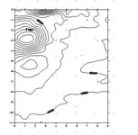
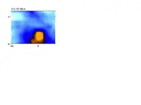
Now, finally, the graveyard. Here is the results of our GPR survey. The colored area of interest (I won't say for sure it is a gun but it is most likely metal). The contour plot is from the magnetometer which also shows an area of interest in the same location. I'm not going to go into the details, but it doesn't look like the graves we also identified, and isn't deep enough.
That's about it. Except I'm not really that young. I'm 35 years old.


")