Ray S S
Silver Member
- Joined
- Nov 18, 2007
- Messages
- 3,011
- Reaction score
- 59
- Golden Thread
- 0
- Location
- Port Huron, Mi.
- Detector(s) used
- Freedom Ace Coin Commander and Ace 250
- #1
Thread Owner
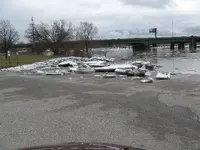
The first pic is ice shoved up on the boat launch ramp. These pics are of the Black River that flows into the St.
Clair River which is the big river and International Boundry between the U.S. and Canada.
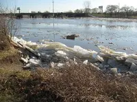
Number is some more pile-up. That square thing floating down river is a set of stair treads likt the ones on a deck.
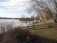
Number 3 shows a bout hoist in front of a house with the ice going along the river bank.
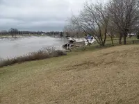
The next couple of days after taking the pic showing the bout hoist, the ice started jaming up at a bend down river
a bit. That caused the water and ice to back up quite a ways up river. when it broke loose it carried a lot of debree
along on the flood waters and ice. This is what is left of the boat hoist in #3 pic.
I hope you enjoy.
Ray
Clair River which is the big river and International Boundry between the U.S. and Canada.
Number is some more pile-up. That square thing floating down river is a set of stair treads likt the ones on a deck.
Number 3 shows a bout hoist in front of a house with the ice going along the river bank.
The next couple of days after taking the pic showing the bout hoist, the ice started jaming up at a bend down river
a bit. That caused the water and ice to back up quite a ways up river. when it broke loose it carried a lot of debree
along on the flood waters and ice. This is what is left of the boat hoist in #3 pic.
I hope you enjoy.
Ray


 But i ain't talkin' Nice photos!


