The Many Lost Treasures of Mariposa, CA (Photos Added)

OP
OP
EagleDown

EagleDown

Bronze Member
May 13, 2010
1,857
629
California
Detector(s) used
Whites MXT, Whites TDI
Primary Interest:
All Treasure Hunting
TheRandyMan said:
Very, very pretty! :headbang:

Halito RandyMan, Thanks for the response! Once again, from the dearth of posts, I was beginning (again,) to think that I was wasting my time in posting. :dontknow:

Eagle
 

calisdad

Bronze Member
Sep 8, 2010
1,237
442
Groveland, CA
Primary Interest:
All Treasure Hunting
Always read your posts Eagle.

To put the Merced in perspective, all the gold that was in the Yosemite valley has flowed, or is in the process of flowing, down that river.

The 75 mile quartz vein you referenced. Is that the same one visable from Hwy 49 near the Tolumne/ Merced county line?

regards,
C-dad
 

OP
OP
EagleDown

EagleDown

Bronze Member
May 13, 2010
1,857
629
California
Detector(s) used
Whites MXT, Whites TDI
Primary Interest:
All Treasure Hunting
Hi C-dad,

Thanks for your post!! I know you read my posts, it's just that it's nice to have it confirmed occasionally.

I couldn't say for certain. I've never flown over it and never have tried to track it. But frankly, it wouldn't surprise me if it was.

Now, if one of these computer geeks would get on the ball and design me a plug-in that would interphase with Google Earth for closer and better resolution.......... :notworthy: :laughing7:

Since the Yosemite Valley was scraped out (created) by glacial action, and since the glaciers came down through Canada, I wouldn't be shocked if we found an occasional diamond in the river along with the gold. Worth dreaming about anyway. :laughing7:
 

shepcal

Full Member
Mar 19, 2003
217
149
Oakhurst,CA
Detector(s) used
modded 4500, CTX30-30, Gold Monster1000
Primary Interest:
Prospecting
Eagle, still don't post much. Missed you on your trip up here, getting my stuff ready to spend a week there (only above). Gonna spend a week around Bonnel Gulch and here and there. See if it's worth more day trips thru the summer.
Always check TN for your posts and enjoy when I find them-
Shep
 

OP
OP
EagleDown

EagleDown

Bronze Member
May 13, 2010
1,857
629
California
Detector(s) used
Whites MXT, Whites TDI
Primary Interest:
All Treasure Hunting
Hello Shep,

Thanks very much for dropping in!! Who knows, gas has dropped back down under $4 a gallon. So, I might be able to get back up your way in a couple of weeks.

Perhaps we can hook up then.

Good luck on your "poking around".

Eagle
 

OP
OP
EagleDown

EagleDown

Bronze Member
May 13, 2010
1,857
629
California
Detector(s) used
Whites MXT, Whites TDI
Primary Interest:
All Treasure Hunting
A couple more, (for perspective) before I go box an order for shipping.

This is the bridge at Briceburg, after crossing to go down-river. After crossing it, the road rises another 10 ft. or so, as you can see in the first photo. So, at this particular point, the road is probably 40 ft. above the river. Keep this in mind for the next couple of pictures. (Later.) :laughing7:
 

Attachments

  • P4170077.JPG
    P4170077.JPG
    60.9 KB · Views: 380
  • P4170078.JPG
    P4170078.JPG
    63.4 KB · Views: 400
OP
OP
EagleDown

EagleDown

Bronze Member
May 13, 2010
1,857
629
California
Detector(s) used
Whites MXT, Whites TDI
Primary Interest:
All Treasure Hunting
Anomalies

After all the years I spent on this river, I have never figured out where these boulders came from. I have explored many miles of the river, from Cranberry, all the way down to Bagby, and nowhere else have I ever seen Basalt boulders. (Volcanic.)

These are about a quarter mile down-river from the Briceburg bridge. As you can see, they are well water worn. (And, at least 40ft above the present river.)
 

Attachments

  • P4170075.JPG
    P4170075.JPG
    85 KB · Views: 430
  • P4170076.JPG
    P4170076.JPG
    79.8 KB · Views: 431
OP
OP
EagleDown

EagleDown

Bronze Member
May 13, 2010
1,857
629
California
Detector(s) used
Whites MXT, Whites TDI
Primary Interest:
All Treasure Hunting
calisdad said:
Eagle, So was the road from Briceburg down river to McCabe Flats open?
TIA-
C-dad

Yes, the road was open all the way down to not only McCabe Flats, but also to the end. (At RR Flats.)
:icon_thumleft:
 

OP
OP
EagleDown

EagleDown

Bronze Member
May 13, 2010
1,857
629
California
Detector(s) used
Whites MXT, Whites TDI
Primary Interest:
All Treasure Hunting
Some more photos of "new" aluvial.

Except for the last one, I've out-lined the bed-rock and painted arrows to the largest river boulders that are visable in the picts.

The 3rd one has been exposed since the 1960s. There were some good sized pickers under it. I never did finish there.

The boulders don't look as impressive in the photos as they do in actuality, just keep in mind that; as a general "rule of thumb", one cubic yard equals (about) one ton. :o

The fourth one should be worth "sniping". It's been uncovered fairly recently and sure looks sweet to me. :headbang:

Can anyone tell me the common denominator in the first four pictures?? :dontknow:

Incidently, I have quite a few more pictures to share with you, so if you get tired of me posting them, just let me know. :laughing7:

Eagle
 

Attachments

  • P4150053.JPG
    P4150053.JPG
    85.4 KB · Views: 415
  • P4150033.JPG
    P4150033.JPG
    95.5 KB · Views: 404
  • P4150032.JPG
    P4150032.JPG
    93.4 KB · Views: 420
  • P4150031.JPG
    P4150031.JPG
    83.1 KB · Views: 398
  • P4150034.JPG
    P4150034.JPG
    93.5 KB · Views: 402
  • P4150053.JPG
    P4150053.JPG
    85.4 KB · Views: 398

NaturalJWL

Hero Member
Jul 19, 2007
577
46
NC
Hello Eagle,

Your pictures and post are definately appreciated. :icon_thumright:

I read more than I post and am learning a lot from you, Thanks. :notworthy:

You mean besides the yellow arrows. LOL :laughing7:

First four appear to be natural riffles of your sluice. :hello2:
 

OP
OP
EagleDown

EagleDown

Bronze Member
May 13, 2010
1,857
629
California
Detector(s) used
Whites MXT, Whites TDI
Primary Interest:
All Treasure Hunting
:laughing9: :laughing9: :laughing9: I'm glad I'm not the only comedian in Tnet. :laughing7:

Hey JWL!! Don't dis the arrows, I just recently learned how to screw up photos with them. And I'm proud of my accomplishment. :laughing7: :laughing7:

Great answer on the common denominator. Every place that you find large boulders, in or out of the river, you're going to find a large dip or crevasse in the bed-rock. (And usually gold in the lowest part of it.)

Thanks for the reply!!

Eagle
 

OP
OP
EagleDown

EagleDown

Bronze Member
May 13, 2010
1,857
629
California
Detector(s) used
Whites MXT, Whites TDI
Primary Interest:
All Treasure Hunting
Hokay, I've had a busy day, so I decided to post this next set now, before I collapse for the day. :laughing7:

In a much earlier post, I mentioned some crevasses maybe 30ft higher (or more,) than the river. In the 1970s through the 80s, there were several exposed here that the "old timers" had dug out. They must have been looking for gold. :laughing7:

Most of the cravasses have been filled in, probably by the BLM. But, evidence still exists.

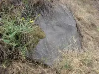
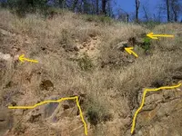
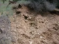
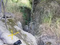
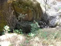
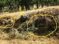
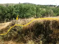
The first one shown was filled with rocks, then covered with "dirt". I outlined it so it can be seen.

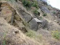
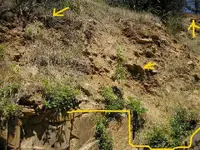
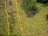
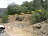
The second shows one that wasn't filled in. You can see where I dug a hole in the bottom. I went about 6" deep but still not to bed-rock.

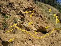
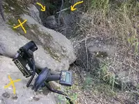
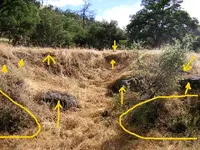
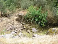
The third one was BIG. I left my MXT leaning on one of the boulders, attempting to show the size of the crevasse and the two boulders with the Xs. The arrows show the sides, which are about 26" apart.
I figured that the boulders weighed over 2 tons each. I doubt that they were moved to clean under them. :dontknow: :laughing7:

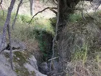
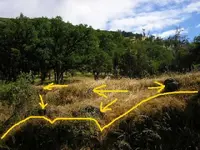
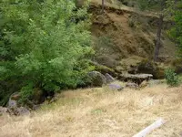
The fourth is one of the same boulders, and a better view of the crevasse. The crevasse narrowed to about 16" then widened back out.

The fifth is the same as the fourth, but at a slightly different angle. Note the old, old live oak in the background. You’ll see it later, at a different angle.

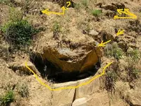
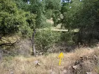
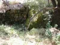
In the sixth photo, I’m not sure about the stone wall. I do have a theory about the reason for it that I’ll present later. I’d like to hear some of your thoughts about it. Granted, it won’t be easy, since you’ve never seen it and the surrounding terrain.

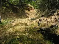
The seventh shows the end of this crevasse and the hill where they stopped digging. You can see some large river boulders sticking out of the bluff where they stopped digging. On the right side of the photo, it looks like they followed the crevasse but didn’t work this area. This is one of the clues that helped me formulate my theory.

In the eighth one, there’s the live oak I asked you to watch for. Also, a ledge above the crevasse that has river gravel showing on it. Perhaps the ledge was too small for them to bother with. OR, it might have been enclosed in the surrounding bed-rock and wasn’t noticed. Perhaps, long after they were gone, the section of bed-rock rotted off, and when it fell off it exposed the gravel. (And maybe some nuggets.) (I wish I had thought of that while I was there.

Look closely, you can see a stone wall that the arrow points to. Can you spot anything else??

Well, that’s it for this batch. But, I have more for you. Enjoy.

Eagle
 

Attachments

  • P4150051.JPG
    P4150051.JPG
    78.8 KB · Views: 391
  • P4150050.JPG
    P4150050.JPG
    80.4 KB · Views: 389
  • P4150048.JPG
    P4150048.JPG
    81.1 KB · Views: 390
  • P4150047.JPG
    P4150047.JPG
    79.6 KB · Views: 385
  • P4150046.JPG
    P4150046.JPG
    79.7 KB · Views: 378
  • P4150045.JPG
    P4150045.JPG
    83.1 KB · Views: 388
  • P4150038.JPG
    P4150038.JPG
    84.3 KB · Views: 398
  • P4150044.JPG
    P4150044.JPG
    86.9 KB · Views: 396

racefanrob

Jr. Member
Feb 7, 2011
32
1
San Jose, Ca.
Detector(s) used
White's MXT
Hello again Eagle,
Once again you get the mind racing... :hello2: Those are awsome pics and I hope to get there soon as well. The kids are almost out of school and I will take a road trip for sure this year. You sure do notice alot of things that I wouldn't see. Thanks for the lessons you are the best. If you find time PM me your address so I can get that rock we talked about to you.

Take care,
Rob
 

OP
OP
EagleDown

EagleDown

Bronze Member
May 13, 2010
1,857
629
California
Detector(s) used
Whites MXT, Whites TDI
Primary Interest:
All Treasure Hunting
racefanrob said:
Hello again Eagle,
Once again you get the mind racing... :hello2: Those are awsome pics and I hope to get there soon as well. The kids are almost out of school and I will take a road trip for sure this year. You sure do notice alot of things that I wouldn't see. Thanks for the lessons you are the best. If you find time PM me your address so I can get that rock we talked about to you.

Take care,
Rob

If you think those pictures are awesome, wait until you see the next set!! :o :laughing9:

Sure wish I had access to a MineLab 5000. :dontknow:
 

OP
OP
EagleDown

EagleDown

Bronze Member
May 13, 2010
1,857
629
California
Detector(s) used
Whites MXT, Whites TDI
Primary Interest:
All Treasure Hunting
Hokay, how about another of my two favorite areas.

In this first photo, I’ve circled a couple of areas of bed-rock. Actually, it’s on the side of the road and runs for maybe 100 yards. Most of it was heavily covered with grass, so it is hard to see, unless you know where it is. (Like me.) :laughing7:
In regards to the 2 arrows above, the lower is pointing to a large river boulder and the top one points to the approx. area where the young lad found a nugget on top of a gopher mound, shortly after a light rain. :dontknow:

The second is a wide deep notch in the bed-rock with many river boulders in and on it. The arrows point out the boulders, (There are many other boulders that don’t show up in the pic,) and to the left and right, I’ve circled the bed-rock I could see through the grass.

This third photo is a section of the bed-rock that has numerous ups and downs. Arrows point to boulders on top of these numerous ups and downs. I’ve also attempted to outline the exposed bed-rock.

The fourth and final photo of this batch is more bed-rock, (outlined) And, one humongous boulder of approx. 2 and a half tons.

I seriously doubt that this area has been worked. I could be wrong, but I figured that when the Yosemite RR was given sections of land along the right-of-way, the work crews exposed the bed-rock, but no one was allowed to mine it. (Or not.) :dontknow: :laughing7:

What really intrigues me about it is; most of the bed-rock appears to be covered by only about a foot to 2ft of dirt. (And boulders.) A good deep-seeking metal detector should be able to pick up some. If I had access to one of Mine Labs 5000 detectors, I believe I could prove; “Thars GOLD in them thar hills”!!! (“STILL”)!!! :laughing7: :laughing7:

Enjoy, Eagle
 

Attachments

  • P4160061.JPG
    P4160061.JPG
    84.6 KB · Views: 386
  • P4160060.JPG
    P4160060.JPG
    68.3 KB · Views: 381
  • P4160058.JPG
    P4160058.JPG
    90.8 KB · Views: 586
  • P4160057.JPG
    P4160057.JPG
    97.7 KB · Views: 404

ellingtonk

Greenie
Mar 4, 2008
10
0
Re: Lost Treasures of Mariposa, CA (Photos Added)

Hi EagleDown,
your stories & memories bring back alot of memories.
We were camping & dredging near McCabe flat when the Big Fire came down the hill (almost to the river) in the mid 70s.

Concerning detecting the 'old areas' you depicted, I may know someone who detected there but it was long ago (again in the 70s) when detectors were weaker. Do you know about detecting/prospecting the hillsides above the conjunction of Bear-Creek & the river?
When I was a boy (40 years ago), you could clearly see where the water cannons had washed down the mountains above there & some remains of water-cannons were there. Now the hill is mostly grown-over & it's hard to see where they washed it away, but there was big part of the mountain defaced. I knew about a guy who detected some nuggets up there, but nearly died in the rock slides... I thought maybe some safer prospecting would be nearer to the bottom.
it's all very overgrown now.
~~~~~~~~~~~~~~~~~~~~~
Not to switch context, but on this thread you spoke about scouting for a mine in Bishop.
Have you hear any tale of this 'crystal cave mine' I found in that locale, or advice?
http://forum.treasurenet.com/index.php?topic=144853.0
More details on this mid-thread here:
http://forum.treasurenet.com/index.php/topic,140261.msg1036779.html#msg1036779
~~~~~~~~~~~~~~~~~~~~~
Back to detecting the high cracks & rocks...
one day camping there near Mcabe Flat by 'House Rock' in the late 70s a group of 3 loud drunk fellas came 'working' there way down the river (from upstream). They were hiking & scrambling along the river-canyon, but way up high, on the hill above the road. Perhaps they were 'hard-rocking'; I don't know. They we're drunk & onery & cussing at each other; and slipping & stumbling alot I could see. Every now & then they'd stop to dig (or fight) or both; and do some dry-panning or sampling.
Finally, when they reached our camp, when the loudest & drunkest of them slipped & fell head over heels. I watched his body flip full length several times, bouncing off the rocks, until he hit the road flat on his back. My dad joined me from camp - a plume of dust rose & his buddies were still hollering. They scrambled down. The guy didn't move & I figured he was dead but he was just knocked out. Being drunk probably saved him. His buddies hauled him to his feet & soon they were all yelling & cussing again. Before taking off, they had some boasting to do. They showed me the gold they'd collected & they all had around 1/4oz to 1/2oz each in small raw looking pieces.
Determined, I later took a detector tried scrambling up the bank, but it was too slippery.
So I detected between the road & the river, as close to the road as possible. I did fine some cracks to works, & panned up some pieces of gold & nails; more than I expected, but not like theirs. I've had better luck working the high-banks on the opposite side below Jack's claims where some big quartz veins come down the hill mixed with slate.
Sorry to ramble.
To sum up:
- any info/advice on the 'crystal mine'? Because it's a beauty of nature, I hate to see it (or that area) harmed.
- how about detecting the hydraulic talings above Briceberg?
Kind regards, Kurt
ps - I live near Triangle Road in Mariposa Co.
 

OP
OP
EagleDown

EagleDown

Bronze Member
May 13, 2010
1,857
629
California
Detector(s) used
Whites MXT, Whites TDI
Primary Interest:
All Treasure Hunting
Halito Kurt,

Welcome to this thread. And “ramble” all you want. In this thread, it’s all about sharing and learning.

As for detecting the hydraulic tailings above Briceburg, I imagine you’re referring to the area along Bear Creek below the Octagon (restaurant) ? I know it’s no longer a restaurant, it appears to be a private residence now. Jim Houtz bought the (patented) land in the late 80s. I didn’t check to see if he still owns it. ("Typo".....Changed to "late 80s"...)

But, back to your question. No, I’ve never detected there, but, it should produce a few sweet nuggets. With two canyons converging there, (one from the “Sweetwater Ridge”, and the other from the direction of the King Solomon Mine.)

I have dredged, (5”) here and there from just below the Octagon to about ¾ mile above there. (Where the big wash comes in from towards the hiway.) I dredged in the Bear Creek “canyon” for a couple of seasons and found some awesome ½ and ¾ oz nuggets. I pulled my equipment out after some LOW LIFE @%$&&*#$ stole my proto-type gasoline powered winch. The only clues I found were tire tracks (obviously a truck) and the knowledge that only a 4X4 could drive out of there. :angry4: :angry5: :cussing:

Well, I have a lot more writing to do in answering your post, but I have a promise to keep also. I have to leave in a few minutes. I just wanted you to know that I wasn’t ignoring you!!

I’ll try to get back in the thread tomorrow at the latest.

Thanks for dropping in!!

Eagle
 

OP
OP
EagleDown

EagleDown

Bronze Member
May 13, 2010
1,857
629
California
Detector(s) used
Whites MXT, Whites TDI
Primary Interest:
All Treasure Hunting
Well, it's Sunday, three more days to June 1st, and I'm getting confused. If no one has noticed, we're having weather that's totally unusual. Today it's rainy (here) and totally overcast. I've lived here for over 10 years and never seen rain at this time of year. So, it is getting rather difficult to make plans that involve prospecting, or any other type of outdoor activity as far as that's concerned.
I am tempted to go on a long "rant" about the reasons for the unusual weather, but, that's not what this thread is about. So, I'll just leave it at: Welcome to "Global Warming". Oh yeah, the temperature is in the low 50's right now. (Should be in the mid-70s.)

I'm posting the following pictures as they pertain to McCabe Flats. Though the BLM has filled and leveled about 2/3 of this area, you can still get an idea of how much work Don Brown did here. I'm only going to put one mark on the photos, as they're pretty well self-explanatory. The arrow will point the way to an extensive mining operation. I seem to have lost a couple of photos during the transfer to my computer. One of them showed the old road leading up towards the operation. It's now blocked with boulders, (by the BLM,) to keep anyone from driving up that way. No problem, if you are phyically fit, you can still hike up to the old mines. It's only about a hundred yards, off to the right. There should be some artifacts and other things. Watch your step though, the last time I was up there, (in the late 70s,) I found a square hole that was about 5ft by 5ft and was about 8 or 9ft deep, before it got down to a bed of leaves. I didn't have a long probe to check it out, so I figure that after perhaps over a 100 year period, there could be as much as 20ft of leaves before the bottom. (Or, it might have been an old "privy" and only a couple more ft. deep.

Enjoy,

Eagle
 

Attachments

  • P4170073.JPG
    P4170073.JPG
    79.6 KB · Views: 463
  • P4170074.JPG
    P4170074.JPG
    74.8 KB · Views: 448
  • P4170072.JPG
    P4170072.JPG
    67.1 KB · Views: 429
  • P4170073.JPG
    P4170073.JPG
    79.6 KB · Views: 392
  • P4170074.JPG
    P4170074.JPG
    74.8 KB · Views: 382

Top Member Reactions

Users who are viewing this thread

Top