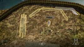
The "U" shaped structure

The U-shaped structure was excavated and dated some years ago. C-14 testing resulted in a date of 1860 +/- 30 years. Samples were also sent to a dendrochronologist who came back with a range of dates, one of which was the late 1800's. The wood used was red spruce. All this info is available at the Oak Island Compendium.

But, Why was it built?
 

Last edited:
Nice Pics guys! Thanks!
Charlie's is an old pic from Dunfield's and his attempt. Tough to see details, would like to compare to a pic of Dan's dig.

Gazzahk's looks to be newer like maybe Lag boys attempt with newer gear but I couldn't clearly see the dam wall. Maybe my orientation. Will look for a color one or maybe take a pic off tonight's show depending on what they show.
 

See post #8 - possibly a crib dock (like similar structures built in Canada). Time and tide rotted away the parts that weren't buried in the muck.

https://www.woodyboater.com/blog/2013/02/08/sticks-stones-a-traditional-les-cheneaux-crib-dock-replacement-project/


the problem that I have with the dock idea is the notches that are cut on a 45* angle, and there does not appear to have been anything other than the notches on the top side. see what I mean?

your dock pic has everything horizontal, not angled up. makes me wonder why.
 

Did anyone notice the long (modern-day) cable protruding from the dirt (about 4 feet down), after Billy scooped away some earth. Good old Rick and another fella (can't recall) were down in the ditch with shovels. The cable was definitely modern, and the exposed part might have been about 20 feet (looped). What is THAT doing there?
 

And there was absolutely no reaction form Rick and crew. The cable then poofed after an edit . . . never to be seen again.
 

The smiths cove area has been dug up so many times. As Charlie P. (NY) pointed out in a thread somewhere, there are posted signs leading to the common wharf structure that the brothers are “re-discovering”. After folks stop watching the show, in another 20-30 years someone else will “discover the mysterious u shaped structure” and start another show after the current show is forgotten.

They are so desperate that they made up their own “cryptic stone” after figuring out it was public knowledge that a “90 foot stone” was a fake created by a company looking to continue to milk investors.

Yep.....the island has never had anything deposited in it except for stuff put down outhouse holes or common items that folks dropped out of the pockets. No bacon/shakespheare/amundson fictional beal code items, etc.

The average guy with a $600 metal detector finds more items in a 4 hour session than these guys have found in years after fleecing advertisers of millions.....
 

Did anyone notice the long (modern-day) cable protruding from the dirt (about 4 feet down), after Billy scooped away some earth. Good old Rick and another fella (can't recall) were down in the ditch with shovels. The cable was definitely modern, and the exposed part might have been about 20 feet (looped). What is THAT doing there?

I saw that too... wondered about it but had a long weekend off and forgot to post about it.
Prob has something to do with that lil tractor they have in there. When I first saw it I was laughing. What's that gonna do? Haha.
Bet they tie the lil tractor to something else so it don't tip over or if it starts to sink, they can pull it out.

That's my guess... :occasion14:
 

Prob has something to do with that lil tractor they have in there. When I first saw it I was laughing.

Me too ...

41476ECE-769C-41DD-8B9D-A7DFFF90A092.gif

Blooper ?
 

after fleecing advertisers of millions.....
Actually the advertisers are doing well.. With the ratings that this show is getting the advertisers are getting a good return on their investment... Just shows that a "made up" treasure story sells a lot better if it is based around an actual legend... We all like they idea of finding buried treasure...
 

A more accurate depiction of where things that have been found in Smiths Cove are..

sc-3.jpg

that is the point of this thread. what the hell was it for?


I would think that this shows the U Shaped structure is part of an attempt to block the flood tunnels...
 

Last edited:
I started this thread because I hoped to have a serious discussion about what t "U" shaped structure was for. it is a shame, but not a surprising shame, that the usual cast of clowns has decided to sidetrack this into their own little "pissing party"
 

I don't see any sign that the structure had any height to it. how it could hold water back. I keep thinking that it is a base for something.
 

That is what I have been saying. Who builds virtually anything out of logs that is only 1 log high... Guess some of them could have gotten washed away over the years but..............
 

any idea what the elevation is at low tide?
 

Hopefully they will have that whole area surveyed and locate each item found before they have to cover it all up, then they can map it out.. Something that should have been done many years ago...
 

A better question is "What WAS the elevation between tides at the time it was built/used?" and maybe higher pieces above water then, are long rotted and washed away. It only takes one good storm to bury a beach feet deep in debris. Anything not dug out for continued use, just keeps getting more debris piled on.

The newly posted illustration of the cove above looks like an old breakwater and boat hauling ramp.

Anyway....have a good day all. OH, I liked the little well we've never managed to be shown before when they were looking for more of that stone. All nicely capped with glacial stone and concrete.
 

Top Member Reactions

Users who are viewing this thread

Back
Top