gjb
Sr. Member
- #1
Thread Owner
I’m posting here, rather than on the Oak Island forum, hoping for a true treasure hunter’s perspective on the subject.
Unfortunately, serious study of Oak Island has been cursed by The Curse of Oak Island and History (Channel)’s money-making projects promoting the Templars. However, this post is not about popular trends, it's about treasure maps.
The subject of treasure maps is widely treated with disdain - at least, beyond true treasure hunting circles - and, with respect to Oak Island, particularly the maps associated with Hubert Palmer and Harold Wilkins. So bad is the situation that almost nobody will now contemplate the application of these maps to the mystery of the island (which is increasingly being declared to be a hoax).
I’m hoping that maybe members not tied into Oak Island preconceptions will be able to stand back, suspend disbelief, and assess these maps as treasure hunters not as confirmed naysayers.
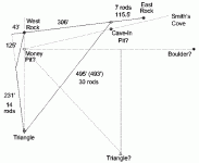
The thesis is that the ground markers on Oak Island (the Money Pit / Tree, the Drilled Rocks and the stone triangles) were positioned according to a strict geometrical plan and that the map instructions were encoded to be applied to these markers in order to identify a pattern of points on the ground.
I’ve put together a summary, a brief overview, and would welcome a treasure hunter’s perspective on the possibility that the instructions on these maps apply to the ground markers on Oak Island and to the geometry deduced from their reported locations. The first two maps shown are the Palmer maps published by Rupert Furneaux in 1972 and the others were published by Harold Wilkins in 1935 and 1940. Please see my web page at:
Oak Island Geometry and Treasure Maps
The instructions on all five maps are decoded according to a common set of rules. As in the last figure, the average variance of the derived points from their targets is about eight inches over considerable distances.
I really would appreciate a serious treasure hunter’s view on this. Would you be tempted to follow up the suggestion or attribute it all to coincidence? Could treasure maps on a grand scale be a reality? I've been unable to influence anybody on the island for the past 35 years.
Note: It's assumed that the magnetic compass was used to maintain bearings while tunnelling, so the angle of magnetic variation features in the geometry. In this reconstruction, this is the angle represented by two-fifths the tangent of thirty degrees (13 degrees NW). The Welling Triangle is angled at one-fifth the tangent of 30 degrees.


