What's new

Undiscovered treasure galleons

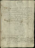
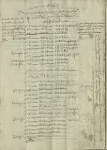
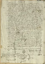
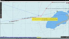
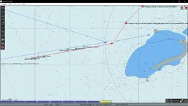
The 1605 fleet did not sink in the Serranillas. Calculation of the course they have been near Bajo Nuevo when the leading ships the roque fired the warning shots. At that time only the 4 leading ships were together and turned east. By then the roque was the last ship of the 4 ships. Here some of the stuff which was on those ships. Need more stuff on the 1605? Was in Honduras and archive in Sucrelast year and now in Bogota. Research is everything.
 

Attachments

  • 1 1603.webp
    1 1603.webp
    2.3 MB · Views: 123
  • 3 1603.webp
    3 1603.webp
    2.5 MB · Views: 126
  • 2 1603.webp
    2 1603.webp
    2.8 MB · Views: 103
Hi. About myself? I am marine electrical engineer, so I travel a lot. However the last 3 years I was involved in investing various shipwrecks . 1605 and the 1708 San Jose.
Since the Qhara Qhara indigenous from Bolivia have a claim on the ship, cause they are the owners of the Potosi mine, and the land around there, I became delegate for this tribe after being in Potosi. Which again brought me to Cartagena last year when the official start of the salvage was announced. There II met w Correa culture minister, ambassador of Spain, etc.
Since a while I prepare google earth and open cpn with the courses the ships of the 1605 fleet before it got lost. I am a sailor, sailing boats, so my understanding of navigation and ships are large enough to even put weather as trade winds and so on into consideration.
Overlays of modern maps/ charts with old original maps, and satellite view makes an area like Roncador very different.
I guess it’s a lot of work to get closed to the treasure.
The trick is : don’t touch the treasure. It’s getting complicated if u want to drag away 100 tons of gold and 250 tons of silver and the rest. The time Odyssey and Mel fisher are over. Now we have to fight Spain not to get what they never had or owned. We have 150 gallons in Colombia waters alone. That’s a lot of gold.
The Spanish killed 10 million during the 300 years around. That was cheap labor to get that stuff to Sevilla. They literally took the Inca empire and shipped it to Spain. They get nothing now. End of story.
 
Huguette and Pierre Chaunu, SEVILLE ET L’ATLANTIQUE, vol. IV, p. 200
The San Martin and the San Gregorio returned to Seville in October 1606.
Two lines, but what a story.
The story of 4 ill fated galleons.
SAN ROQUE, CAPITANA
SANTO DOMINGO, ALMIRANTA
SAN AMBROSIO
NUESTRA SENORA DE BEGONA
Four of the richest galleons, shipwrecked on the first of November 1605.
Never found.
Never salvaged.
Where are they?
Below is a chart of about 100 years later. The route of the galleons is clearly marked.
Now, where on this chart did the disaster happen?
Shown on a map 100 years later? 🤣 Never Reported Found, Never Reported Salvafged
 
The position of Bajo Nuevo only appeared on the charts much later.
From the deck of a ship, Bajo Nuevo and Serranillas look very similar. The currents in the region are quite irregular so it was very difficult to be certain of the longitude before the invention of the chronometer.
 
The position of Bajo Nuevo only appeared on the charts much later.
From the deck of a ship, Bajo Nuevo and Serranillas look very similar. The currents in the region are quite irregular so it was very difficult to be certain of the longitude before the invention of the chronometer.
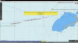
That’s right. They knew to be be in the Víboras. That incl. the reefs around the serranillas. I did plot the course taken the reports of the surviving ships and average speed.
 

Attachments

  • Screenshot (30).webp
    Screenshot (30).webp
    102.4 KB · Views: 99
  • Screenshot (29).webp
    Screenshot (29).webp
    104.3 KB · Views: 93
  • Screenshot (28).webp
    Screenshot (28).webp
    96 KB · Views: 104
The 1605 fleet did not sink in the Serranillas. Calculation of the course they have been near Bajo Nuevo when the leading ships the roque fired the warning shots. At that time only the 4 leading ships were together and turned east. By then the roque was the last ship of the 4 ships. Here some of the stuff which was on those ships. Need more stuff on the 1605? Was in Honduras and archive in Sucrelast year and now in Bogota. Research is everything.
For more docs please contact me.
 
That’s right. They knew to be be in the Víboras. That incl. the reefs around the serranillas. I did plot the course taken the reports of the surviving ships and average speed.
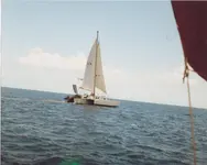
Well after reading the last 5 pages of this thread I'm feeling we were very lucky with our 'encounter' at Serranilla in the late '80s when we sailed our sailboat past there. My conversation with the soldier wasn't 'friendly' (i.e.: couple shots over my head) as I kept insisting it was joint jurisdiction. Wasn't till I talked to Charge de'affair in Colon that he informed me President Reagan had relinquished the dual jurisdiction claimed by President Kennedy. He was surprised I didn't get shot. We talked to a Canadian cruiser afterwards who had a 'similar encounter' and he informed me that the 'black telescope with 2 guys on cinderblock building' we saw was a 50cal. machine gun. Boy we were dumb.
 

Attachments

  • trimaran 2, marquesas 001.webp
    trimaran 2, marquesas 001.webp
    338.1 KB · Views: 93
Huguette and Pierre Chaunu, SEVILLE ET L’ATLANTIQUE, vol. IV, p. 200
The San Martin and the San Gregorio returned to Seville in October 1606.
Two lines, but what a story.
The story of 4 ill fated galleons.
SAN ROQUE, CAPITANA
SANTO DOMINGO, ALMIRANTA
SAN AMBROSIO
NUESTRA SENORA DE BEGONA
Four of the richest galleons, shipwrecked on the first of November 1605.
Never found.
Never salvaged.
Where are they?
Below is a chart of about 100 years later. The route of the galleons is clearly marked.
Now, where on this chart did the disaster happen?
Bajo Nuevo. That’s pretty clear by now. Q: did only the Son Roque hit the reef at Bajo Nuevo or all leading ships.
 
Huguette and Pierre Chaunu, SEVILLE ET L’ATLANTIQUE, vol. IV, p. 200
The San Martin and the San Gregorio returned to Seville in October 1606.
Two lines, but what a story.
The story of 4 ill fated galleons.
SAN ROQUE, CAPITANA
SANTO DOMINGO, ALMIRANTA
SAN AMBROSIO
NUESTRA SENORA DE BEGONA
Four of the richest galleons, shipwrecked on the first of November 1605.
Never found.
Never salvaged.
Where are they?
Below is a chart of about 100 years later. The route of the galleons is clearly marked.
Now, where on this chart did the disaster happen?
How would anybody know the route 100 years later? Thats perhaps true. But the ships left 1. November and hit a tropical depression 6 days later near Serranillas . In the evening the wind changed to s to sw, means those ships had to turn more East of Serranillas. At 4-5 nm after evening prayer about 6 hours later as the survivors reported they were near Bajo Nuevo.
 
About the Cordoba fleet.
Thanks for correcting the date.
As to where the shipwrecks are, please give me some time to check the available information. This is the purpose of this thread.
Old documents are difficult to read, but even much more difficult to interpret. It is not only a matter of language, but also a matter of deeper understanding many factors that influenced the way the story was written down.
I doubt if one single person can have all the knowledge to successfully interpret a story like the sinking of the Cordoba Fleet.
For example:
It needs profound knowledge of the prevailing wind and weather conditions in the region, at the time of the year, that is the beginning of November. And was this a usual weather pattern year? Was this an exceptional storm? Do we have any information about unusual current or wind patterns?
Profound knowledge of the navigation the way it was done in those times.
Knowledge of sailing in the times.
Understanding of conditions on board a ship, in the darkness, in a howling storm, with the only light being the flashes of lightning.
Understanding the psychological condition of the surviving eyewitnesses, during the time they are describing and during the time they are responding to the inquirer.
The list can go on and on. Each one of these factors may produce information that can be wrongly interpreted at the time of the depositions as well as in modern times.
So forgive me if I want to go over the publicly known information with a team of experts in the different fields before deciding on the priority search area.

I have noticed that there are quite a few people on this forum who have dedicated time and accumulated experience in interpreting shipwreck information. Why don't we listen to all of them. Let's see what the opinion of each one is and how he came to his conclusions.

We all might learn something by listening to all the different opinions, not just one or to.

CP
True. Let’s say a follow up on real navigation applications charts with the speed of a galleon 6 days of voyage puts the ships in a position which makes sense to be near the Serranillas. The weather they got was a tropical storm. They reported wind from the sw in the evening 6 november. Overlay the map with an anti clockwise weather system, and yes you know which direction they were heading then. For 6 h at about 4-5 nm speed.
 
On another trip down to Panama besides stopping at Serranilla we stopped at Bajo Nuevo. Didn't have a mag so I 'trolled' my brother around behind the inflatable. "Mark One Eyeball". Didn't see anything off the reef but there were shrimp-boat type anchors visible on top of the reef. That should have been a 'clue' that any galleons may have been driven right over the reef and inside the lagoon? Later we ran into Tony Kopp (Swedish treasure-cruiser) and he said there was a 40-gun wreck on the backside of the key. We dove one submerged old steamer we found and boarded the large freighter that was run aground. Boarded it via climbing the anchor-chain and got the steam whistle the Jamaican fisherman hadn't stripped. By pure luck I found the 'Ships Builders Plaque'. Our younger brother has them. We never returned to Bajo Nuevo as the 'Serranilla' experience changed our mind on Western Caribbean wrecks and we concentrated on Panama. Found a little treasure and a lot of trouble as twin brother was jailed for 6-? days as a CIA spy and we're 'persona non gratis' there and later in Indonesia. Only upside is we didn't get shot and we both found our brides thru the adventurers.
 
Yep, got to be careful. When was that if I may ask? When you went to Bajo Nuevo . Colombian waters are well protected by the GOC, unless you have a license. Non intrusive. Which we have within another month or so. A preliminary ok is given already. We should use a sailing vessel, I am marine electrical engineer and sailed more than 20 years. In these days a lidar drone, and side scanner plus small rov can do the trick.
WhatsApp. +4550230645, at present in Europe. Best regards
 
Probably about 1986 when we made several trips back to Panama and swung by Bajo Nuevo and a later trip was the Serranilla visit. It wasn't planned per se as the Western Caribbean is usually blowing like crazy and it just happened to be calm so we motored over to the reefs. The Serranilla story is best told over a couple beers.
 
Bajo Nuevo. That’s pretty clear by now. Q: did only the Son Roque hit the reef at Bajo Nuevo or all leading ships.
To understand what happened to the fleet, one must take into consideration where the surviving galleons landed.
 
How would anybody know the route 100 years later? Thats perhaps true. But the ships left 1. November and hit a tropical depression 6 days later near Serranillas . In the evening the wind changed to s to sw, means those ships had to turn more East of Serranillas. At 4-5 nm after evening prayer about 6 hours later as the survivors reported they were near Bajo Nuevo.
The fleet sailed in November, because the hurricane season was over. With today's weather and climate information it is easy to verify if it was a "Norther" or a tropical storm. The severe damage to the galleons testifies to a strong storm. I believe I was caught in a similar but lesser storm in 1982 in the same region. Windspeed 55Kn, not quite hurricane strength.
 

Users who are viewing this thread

Back
Top Bottom