A little history of the area from the forestry website as well as a rough map of the locations that we have explored. Like I said, this is such a huge area, and wherever I go I find more and more signs...
Prehistory & History
The roots of human habitation in southeastern Arizona are still being traced, but the clues that have been uncovered have much to say. Finely shaped stone points of the Clovis Culture, found in conjunction with the remains of ice-age mammoths, tell us that these intrepid hunters ranged here as much as 11,200 years ago. The simple grinding and crushing tools of a people archaeologists call the Cochise Culture indicate that they responded to the disappearance of ice-age mammals by broadening their food supply to include a wide range of plants, as well as the deer and other animals which we see in southeastern Arizona today.
Eventually, pottery-making and agricultural peoples, such as the Mogollon and Hohokam, appeared. Their cultures reflect increasingly refined adaptations to local environments, and knowledge obtained from people living to the south, in present-day Mexico. Archaeologists debate their relationship to the later Sobaipuri, Tohono O’Odham and Pima.
These latter peoples were the inhabitants of the land of the Sky Islands when two very different groups of newcomers arrived on the scene, at very nearly the same time. The Apaches were Athabascan nomads from what we now call Canada. The Spaniards were fresh from their conquest of Mexico.
Conquistadores and Missionaries
In 1539, Fray (Friar) Marcos de Niza and a companion named Esteban became the first non-Indians of reliable record to enter what is now Arizona. They came searching for the Seven Cities of Cibola, a metropolis rumored to be richer than the gold-drenched capital of Aztec Mexico. Instead, they found the simple mud homes of pueblo Indians.
Lured by de Niza’s tales of treasure (though he in fact had found none), Don Francisco Vásquez de Coronado mounted a second expedition one year later. The entry of the Conquistadores into what is now the United States is marked by the Coronado National Memorial at the southern end of the Sierra Vista Ranger District. Evidence indicates that Coronado proceeded along a course roughly duplicated by the Montezuma Pass to Sonoita scenic drive through the San Rafael Valley. He continued north and east via the San Pedro and Gila River valleys, on a trek that eventually took him and his army all the way to modern-day Kansas. The expedition, however, was considered a total failure. The land through which it passed held so little of value to the Spaniards that they went back to Mexico and didn’t return for nearly a century.
In the late 1600’s the lure of another type of reward, souls for the saving, brought Father Eusebio Kino to the Santa Cruz Valley. Kino, along with other Jesuits and Franciscans, built a system of missions across the Southwest where the padres vied for the faith of the native Sabaipuris, Pimas and Tohono O’Odham, as well as the Apaches. On the heels of the missionaries came silver miners armed with tools for extracting from the land what their predecessors had failed to find for the taking among its residents.
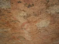
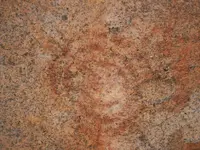
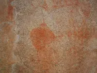
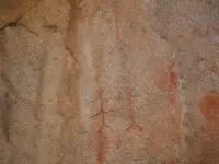
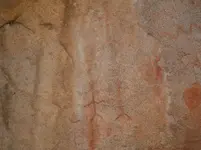
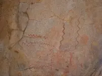
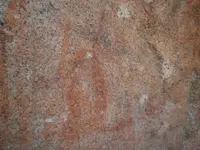
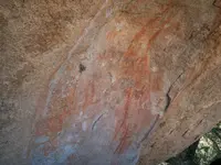
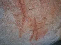
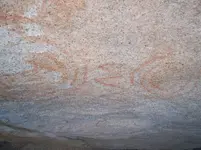
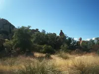
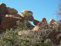
Now, could it be that the indians and the spanish were here at the same time or one before the other? remember that the indians weren't always unfriendly, some say the spanish used them as slaves for their mines. On that one pictograph above the "snake kissing" formation, it looks like a hat of some sort (or maybe an alien which fits my UFO pic lol) and above that in the same scene is two spirals with a mountain range in-between, which on the rough map I drew could depict the small range between the pictographs and the hearts. And all over all three of the ranges are things that could be markers like the heart in the recent pics (the one on top of a hill), and what drew my eye to look that way was a formation of rocks that looked like a hand pointing to it. The hand formation doesn't come through the same in the picture I took, so I didn't post it (everyone would just say it was natural, but it made me turn around and look where it was pointing)
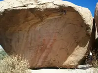
But anyways, like I said, this outing I was concentrating on what I knew was manmade, and getting a lay of the land that you can't see from the road. I needed to know what we would be able to carry when we went to follow those hearts at the bottom of the canyon, and I also wanted to know if those pictographs depicted anything like a map as I had seen them before, but that was before I found this website and I didn't know what to look for.