Wagoner's Lost Ledge

skyhawk1251

Sr. Member
Nov 9, 2018
312
669
Kingman, AZ
Detector(s) used
Fisher Gold Bug Pro
Primary Interest:
Prospecting
I've read several versions of the "Wagoner's Lost Ledge" tale, but the source that I'm using here is taken from Barry Storm's book, "Thunder Gods Gold." Other versions are essentially the same.

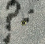
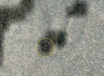
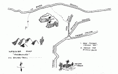
This is my favorite tale of lost gold in the Superstition Mountains. It seems to be well documented, and a map comes along with it. There are many rocky outcroppings just west of Picacho Butte and south of LaBarge Canyon, so it would take a lot of prospecting to examine all the possible locations of a lost ledge. I would guess, though, if the tale can be considered to mostly be accurate facts, that a tired, hungry man, who was looking for the shortest, easiest way to get where he wanted to go, would give preference to low ground in the arroyos. Also, according to the tale, Wagoner planted trees around the ledge. Trees need a reliable water source to grow, so this suggests a location near an arroyo.

With those clues in mind and using GE, I see one, possible location for the lost ledge. It's not the only possibility; there are surely others, and possibly many others, due to the abundance of outcroppings. The place I've found, however, would make me stop in my tracks and give it close scrutiny.

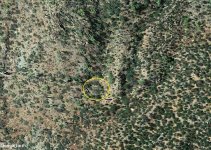
I'm not providing GPS coordinates for the place shown in the GE image below. Follow the right-forking arroyo in the wide-angle view and that place will be found. LaBarge Canyon winds to the left in the image.

Page 19.jpg


Page 89.jpg


Page 90.jpg


Page 91.jpg


Page 92.jpg


Page 93.jpg


C.png


F.png
 

markmar

Silver Member
Oct 17, 2012
4,117
6,259
Primary Interest:
All Treasure Hunting
Storm's derscription of the Wagoner's route, it's the most accurate from all the other sources. But only the route, because then change to Tom Kollemborn story , which says was a Spanish prospect and not an outcrop.
In his story, Storm wrote how from the spring, Wagoner went to the south-east, and I see your spot it's little south-west from an allegedly spring which would be along Labarge Canyon about 3 miles from WN.
One thing we have to take in consideration, it's when a direction told in a story by a non Spanish or Jesuit, the direction should be calculated with the magnetic declination of that era for the specific region. So, in Wagoner era, for the Superstitions has to be calculated with a magnetic declination of about 14 degrees east by North.
When Wagoner said was almost due north from Miner's Needle, he was litlle to the north-east from the peak. And then, he did something different that would do a logic and normal person. Instead to go south-west to the Miner's Canyon he went to the south-east over the broken country in regards to reach the trail which was coming from the Red Tanks Canyon and went to Withlow Ranch.
The reason nobody found the Wagoner-Spanish prospect, is becouse of thinking logical.
The Wagoner's map published in Storm's book, was modified little by the author. In the original map, there it's not a cross marking beside the Labarge Canyon, but only one , the second in the map. In comparison with Spanish and Jesuit maps which are drawing lines following rows of rocks, Wagoner selected as dot lined markings and for the question mark, the canyons, ravines, depresions and faults from the region he wanted to desribe. Acctually, in Wagoner's map, the mine it's at the end of the doted trail, close to the Question marking, and not at the dot below that marking.
Your are right, the mine is in a small ravine. I will post three GE images, the two are overlays of the map, to see the mine's spot and the concept Wagoner used in making his map.
Don't ask for more details. Enjoy
 

Attachments

  • Wag mapOv.jpg
    Wag mapOv.jpg
    177.4 KB · Views: 62
  • Wag mapOv2.jpg
    Wag mapOv2.jpg
    202.7 KB · Views: 67
  • Wag mapOv3.jpg
    Wag mapOv3.jpg
    290 KB · Views: 61
OP
OP
skyhawk1251

skyhawk1251

Sr. Member
Nov 9, 2018
312
669
Kingman, AZ
Detector(s) used
Fisher Gold Bug Pro
Primary Interest:
Prospecting
An excellent post, markmar. Thanks for taking time to reply. In Barry Storm's version of this tale, as in most other tales of lost gold in the Superstitions, when compass directions are included I think "approximate" rather than "exact. " In this case, I don't think Wagoner was consulting his compass very often, if at all. The sun's position and time of day would have been sufficient for any "dead reckoning" to be done, especially since Wagoner didn't seem to have any specific destination pinpointed as his target.

As I wrote, my single possible location for the lost ledge is not the only possibility, but the uplifted and extremely fractured rock outcropping caught my immediate attention. A man walking by it in the arroyo could probably easily see a vein of rose quartz if it was there. The arroyo branching from LaBarge Canyon heads in a southeast direction, which is the way LaBarge wanted to go when he spotted the ledge.
 

markmar

Silver Member
Oct 17, 2012
4,117
6,259
Primary Interest:
All Treasure Hunting
Don't forget, a good hiker like Wagoner can hike at least one to one and half mile in a hour.
 

OP
OP
skyhawk1251

skyhawk1251

Sr. Member
Nov 9, 2018
312
669
Kingman, AZ
Detector(s) used
Fisher Gold Bug Pro
Primary Interest:
Prospecting
Don't forget, a good hiker like Wagoner can hike at least one to one and half mile in a hour.

Probably the speed at which he was traveling if he was tired and hungry. Slightly faster for a person functioning at 100% and if the terrain was open and relatively level.
 

markmar

Silver Member
Oct 17, 2012
4,117
6,259
Primary Interest:
All Treasure Hunting
I doubt Wagoner had not a compass to use, unless he knew so well those mountains, fact that could made him to skip this method. Also his fault to find the proper trail which would lead him to Red Tanks Trail , maybe shows he was not so familiar with that region. Sun is good for orientation, but only in a sunny day.
There are some critical clues in his map and in Barry Storm's description of the route, clues which you and maybe all the other have missed. These clues make things very clear about at which spring camped overnight and the route hiked till the mine.
In the most stories of the Superstitions, the distance from or to WN is underestimated or overestimated, but I'm almost sure how Wagoner, when the terrain would allow, wouldn't go to a different direction than that he wanted to go.
 

OP
OP
skyhawk1251

skyhawk1251

Sr. Member
Nov 9, 2018
312
669
Kingman, AZ
Detector(s) used
Fisher Gold Bug Pro
Primary Interest:
Prospecting
There are some critical clues in his map and in Barry Storm's description of the route, clues which you and maybe all the other have missed. These clues make things very clear about at which spring camped overnight and the route hiked till the mine. -- markmar

I haven't missed those "clues." I'm just saving them for later discussion. My GE images posted earlier are based only on the general location shown on Barry Storm's modernized map. Readers who want to consult Tom Kollenborn's version of the tale can find it here:

http://superstitionmountaintomkollenborn.blogspot.com/2010/01/the-wagoner-golden-ledge.html

Mr. Kollenborn's version opens the definite possibility that Wagoner had found a cache from Spanish diggings.
 

OP
OP
skyhawk1251

skyhawk1251

Sr. Member
Nov 9, 2018
312
669
Kingman, AZ
Detector(s) used
Fisher Gold Bug Pro
Primary Interest:
Prospecting
I want to add some comments pertaining to the Wagoner Map shown on page 19 in Barry Storm's "Thunder Gods Gold" before I diverge to discussing Tom Kollenborn's version of the tale and some details about what Google Earth can and can't do.

First of all, the Wagoner Map is "crude" and its features are not drawn to scale. With that fact in mind, it is not possible to overlay a crude, hand-drawn map over a Google Earth image or a USGS topographical map and to expect that they will correspond to each other. It is possible to trace a route from a USGS topographical map and then overlay it on an overhead Google Earth image and to then have the terrain features in agreement, if a person has the skill needed to manipulate computer graphics; there would be no need to do this, however, since Google Earth can show GPS coordinates for any point on the globe.

When I look at the Wagoner Map, the route to the ledge is clear enough until the dotted line leaves LaBarge Canyon and heads to the south. It is not clear exactly where to leave LaBarge Canyon, nor how far south to go. The question mark means "unknown"; it does not mark the location of the lost ledge. So, the Wagoner Map only shows that the lost ledge is somewhere west of Picacho Butte and south of LaBarge Canyon. Google Earth is not capable of showing the ledge.

I'll use the Google Earth image (below) when I discuss Tom Kollenborn's "Wagoner's Golden Ledge." I've marked all the springs I see on my copy of the USGS topographical map. Please let me know if there are other springs in the area of Picacho Butte.

Page 19.jpg


H.png
 

OP
OP
skyhawk1251

skyhawk1251

Sr. Member
Nov 9, 2018
312
669
Kingman, AZ
Detector(s) used
Fisher Gold Bug Pro
Primary Interest:
Prospecting
"There are some critical clues in his map and in Barry Storm's description of the route, clues which you and maybe all the others have missed. These clues make things very clear about at which spring he camped overnight and the route hiked till the mine." -- markmar

Barry Storm's version of "Wagoner's Lost Ledge" puts Wagoner's overnight camp at Trap Canyon Spring, which is about three miles east of Weavers Needle and almost directly north of Miners Needle. Line-of-sight distances are given below.

WEAVERS NEEDLE TO TRAP CANYON SPRING 2.83 MILES
LABARGE SPRING TO TRAP CANYON SPRING 0.88 MILES
TRAP CANYON SPRING TO LABARGE SPRING NUMBER TWO 2.66 MILES
WHISKEY SPRING CANYON TO LABARGE SPRING NUMBER TWO 1.38 MILES

Barry Storm writes that Wagoner came upon the golden ledge "almost within the hour." Wagoner was heading southeast in an attempt to connect to the trail in Red Tanks Canyon, with his ultimate destination being the settlement of Pinal, near Picket Post Mountain.

My opinion is that Wagoner left his camp at Trap Canyon Spring, went a very short distance to LaBarge Canyon, then left LaBarge Canyon where it connects with Whiskey Spring Canyon. "Almost within the hour" Wagoner found the golden ledge in Whiskey Spring Canyon. I don't believe he walked beyond a point in the canyon that lies farther than directly east of Miners Needle.

The directions given in Tom Kollenborn's version are in good agreement with Barry Storm's version.

------------------------------------------------------------------------

"Wagoner told Fred the quartz had intruded a large black basalt outcrop on the desert not far from the stage route.

"Wagoner talked about seven shallow shafts with ironwood collars near two black hills. At the base of these hills was a stone mill for grinding the ore.

"Wagoner said the gold ore was located four hours walking time north of the "Narrows" on the stage route. The ledge was located near two black hills. A sharp needle rock could be seen on the horizon to the north. Water could be found one mile to the east year-round no matter how dry the season was. Indian markings can be found on the rocks just to the west of the site over some very rough and steep terrain. The old alternate route for the military trail between Fort McDowell and Camp Pinal lies about one mile to the north." -- Tom Kollenborn

------------------------------------------------------------------------

The reliable water source Mr. Kollenborn writes about is most probably LaBarge Spring Number Two. The alternate military trail is described in the forum post below.

"Horse Camp Basin is the area where Brownie Holmes found a 40-acre site of cut mesquite stumps. It is also where the remains of a work camp were found, barrels gone to hoops and staves, new horse shoes, etc. It was also known as the Soldier Camp. One of the oldest trails in the Superstions goes by there, the Old Spanish Trail. Estee Conaster has it starting into the mountains near Miner's Needle, going through the Whiskey Springs area, through LaBarge Box, and northward along the east side of the range that is formed by Herman Mountain, Sheep Mountain, Music Mountain, and onward to the Salt River. Since it went past what was known as the Soldier Camp, could this have been what Jacob Waltz referred to as the Military Trail?" -- von kidd

------------------------------------------------------------------------

So, modern-day explorers heading to the Superstition Mountains would be well advised to take a slow walk along Whiskey Spring Canyon going toward Miners Needle. Wealth beyond imagination could be waiting on a south slope between two black hills.

Page 90.jpg


L.png


M.png


N.png


O.png
 

OP
OP
skyhawk1251

skyhawk1251

Sr. Member
Nov 9, 2018
312
669
Kingman, AZ
Detector(s) used
Fisher Gold Bug Pro
Primary Interest:
Prospecting
Near the end of his tale Barry Storm writes of "a man named Pinkey", who also had a copy of the map to the golden ledge. Apparently Pinkey only had the map and no other details, verbal or written, about exactly where the ledge was located. Pinkey's instructions also were vague about where he was to meet with Wagoner. The "Pinkey story" raises some questions.

The most important question is: why did Pinkey expect to meet with Wagoner when the letter that came with the map, dated twenty years earlier, indicated that Wagoner had died long before? The answer probably is: Pinkey was not expecting to meet with anyone. As far as he knew "the board house" was the starting point of the route to the ledge, and he was ready to begin a search for the ledge on his own. The question remains, however: why did Pinkey wait twenty years to begin his search?

Another question is: why did Wagoner give a map to Mullins, then later gave a map to Pinkey? Did Wagoner directly give the map to Pinkey, or did the map pass through Mullins' hands before Pinkey got it? Did Pinkey pay Mullins for the map?

Page 92.jpg
 

OP
OP
skyhawk1251

skyhawk1251

Sr. Member
Nov 9, 2018
312
669
Kingman, AZ
Detector(s) used
Fisher Gold Bug Pro
Primary Interest:
Prospecting
Could these be the "two black hills" of Tom Kollenborn's version of the tale?

P.png
 

markmar

Silver Member
Oct 17, 2012
4,117
6,259
Primary Interest:
All Treasure Hunting
Yes, Wagoner's map is a crude map made without scale, except the part from the "X" until the mine and question marking. That was the part he could see every time from the mine and for this he drew this part accurately.
The key for the mine, is to know what that "X" in the map represents. It's the spring or something else mentioned in the clues?
 

OP
OP
skyhawk1251

skyhawk1251

Sr. Member
Nov 9, 2018
312
669
Kingman, AZ
Detector(s) used
Fisher Gold Bug Pro
Primary Interest:
Prospecting
The two "X's" on the Wagoner map were added by Barry Storm to indicate the approximate locations where Howland found pieces of rich ore. The annotation on the map clearly proves this fact. The map, and any portion of it, is not drawn to scale. While it's possible to travel different routes to get to Whiskey Spring Canyon, I believe Wagoner always took the route shown on his map. The elevation gains are more gradual and water sources are along that route. Apparently, Wagoner didn't carry many provisions, and he counted on finding water along the way.

The "Narrows" referred to in Tom Kollenborn's version is where Whitlow Dam is located. Pinal City, a stop along the stagecoach route to Florence, was located northeast of Picketpost Mountain.

Page 19.jpg


Q.png


R.png
 

markmar

Silver Member
Oct 17, 2012
4,117
6,259
Primary Interest:
All Treasure Hunting
The one "X", that on Labarge Canyon, on the map from Storm's book , is fake. The orginal map has only the second marking. Storm added that "X" only to mention he knew where Howland found the gold ore. But he didn't know and mistakenly used the second "X" as a referrence to Howland ore. The logic says if Storm knew where that marking of the ore was, then he could easily find the mine's spot, which he didn't find.
This is the Wagoner's map
 

Attachments

  • Wagoner-Map-28.gif
    Wagoner-Map-28.gif
    10.4 KB · Views: 46
OP
OP
skyhawk1251

skyhawk1251

Sr. Member
Nov 9, 2018
312
669
Kingman, AZ
Detector(s) used
Fisher Gold Bug Pro
Primary Interest:
Prospecting
Here's an interesting anomaly south of Whiskey Spring and near black basalt outcroppings. GE images are shown looking north and southwest (overhead view). Could these be low, man-made walls? Did Wagoner construct a crude, rock shelter to protect himself from the wind and critters? Is his golden ledge near the spring, where he might have loitered, took a close look at his surroundings, and discovered the ledge?

Notice that black basalt outcroppings are abundant on the west side of the canyon, while the east side lacks such outcroppings.

V.png


W.png
 

markmar

Silver Member
Oct 17, 2012
4,117
6,259
Primary Interest:
All Treasure Hunting
I don't know if you are doing it intentionally, but seems you have missed the most crirical clue from Barry Storm's book.
Another clue from Kollenborn's collection is about " a spring one mile to the east ". If your region would been the right one, then the clue would say ' a spring 400 yards to the north ".
 

OP
OP
skyhawk1251

skyhawk1251

Sr. Member
Nov 9, 2018
312
669
Kingman, AZ
Detector(s) used
Fisher Gold Bug Pro
Primary Interest:
Prospecting
Barry Storm's version of "Wagoner's Lost Ledge" puts Wagoner's overnight camp at Trap Canyon Spring, which is about three miles east of Weavers Needle and almost directly north of Miners Needle. Line-of-sight distances are given below.

WEAVERS NEEDLE TO TRAP CANYON SPRING 2.83 MILES
LABARGE SPRING TO TRAP CANYON SPRING 0.88 MILES
TRAP CANYON SPRING TO LABARGE SPRING NUMBER TWO 2.66 MILES
WHISKEY SPRING CANYON TO LABARGE SPRING NUMBER TWO 1.38 MILES

I'll remain with my deductions, thus far, unless someone can present a logical argument that pinpoints where Wagoner's camp was located and where he left LaBarge Canyon to head southeast. Whiskey Spring Canyon seems to be a good, possible location for the golden ledge, although I'm sure others have their own preferences. I won't be going there, so I'm a "happy camper" with my conclusions.
 

markmar

Silver Member
Oct 17, 2012
4,117
6,259
Primary Interest:
All Treasure Hunting
WEAVERS NEEDLE TO TRAP CANYON SPRING 2.83 MILES
LABARGE SPRING TO TRAP CANYON SPRING 0.88 MILES
TRAP CANYON SPRING TO LABARGE SPRING NUMBER TWO 2.66 MILES
WHISKEY SPRING CANYON TO LABARGE SPRING NUMBER TWO 1.38 MILES

I'll remain with my deductions, thus far, unless someone can present a logical argument that pinpoints where Wagoner's camp was located and where he left LaBarge Canyon to head southeast. Whiskey Spring Canyon seems to be a good, possible location for the golden ledge, although I'm sure others have their own preferences. I won't be going there, so I'm a "happy camper" with my conclusions.
Then , have a good time in your camping trip :tongue3:. The most logical argument is to think like Wagoner did.
What would do a man who is hungry and desperate to go as quickly possible to reach the trail to Whitlow Ranch in Randolf Canyon?
In my logical opinion, leaving out the distances given because they are the first which cause the most truble in every lost mine story, Wagoner would turn at the first accesible for hiking ravine heading south-southeast beside the Picacho Butte, no matter if there would be a spring or not. He would not make a step in another direction than that which he had thought to go. The story says Wagoner was hungry not thirsty, so he was not looking in purpose for a spring.
So, the logic says how Wagoner camped overnight at Whiskey Spring. His map shows he went south before LaBarge Canyon turns to northwest.
 

Last edited:
OP
OP
skyhawk1251

skyhawk1251

Sr. Member
Nov 9, 2018
312
669
Kingman, AZ
Detector(s) used
Fisher Gold Bug Pro
Primary Interest:
Prospecting
The story says Wagoner was hungry not thirsty, so he was not looking . . . for a spring. -- markmar

Every experienced traveler in the desert has water, first and foremost, on their mind. So, if Wagoner knew the locations of most springs where he was heading, I would guess that he would not want to pass one by. The lost ledge tale seems to suggest that Wagoner was traveling "light." That leads me to think that he, at most, was carrying only a two-quart canteen slung over his shoulder -- the kind of canteen seen in many western movies. Two quarts of water don't go very far in the desert, so frequent refills are necessary.

I've concluded that Wagoner camped overnight at Trap Canyon Spring, then left LaBarge Canyon where it connects with Whiskey Canyon. The spring about one mile east farther along LaBarge Canyon would be LaBarge Spring Number Two.
 

Top Member Reactions

Users who are viewing this thread

Top