What do you recommend for dowsing maps?

Red_desert

Gold Member
Feb 21, 2008
6,846
3,499
Midwest USA
Detector(s) used
Garrett Ace 250/GTA 1,000; Fisher Gold Bug-2; Gemini-3; Unique Design L-Rods
Primary Interest:
All Treasure Hunting
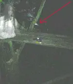
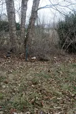
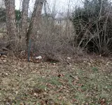
Cold front came through, went out to get new photos of the tree. Leaves are down, you can see it better. Believe this is what they call a clump birch. Has 2 smaller tree trunks off the side at an angle. You can compare with spooky photo diggers took at WW2 dig site. WW2 site photo is more like original and less cropped with the tree more visible.
 

Attachments

  • ghost-lady-arrow.jpg
    ghost-lady-arrow.jpg
    563.5 KB · Views: 26
  • Img_8147.jpg
    Img_8147.jpg
    2.3 MB · Views: 21
  • Img_8149.jpg
    Img_8149.jpg
    1.5 MB · Views: 23

Red_desert

Gold Member
Feb 21, 2008
6,846
3,499
Midwest USA
Detector(s) used
Garrett Ace 250/GTA 1,000; Fisher Gold Bug-2; Gemini-3; Unique Design L-Rods
Primary Interest:
All Treasure Hunting
Anyone looking for maps to check, these all look the same. #005 is zoomed out and takes in all maps #001-004. E-pin is also #005 map (without pins).
 

Attachments

  • 001-zoomed-in.jpg
    001-zoomed-in.jpg
    40 KB · Views: 21
  • 002-zoomed-in.jpg
    002-zoomed-in.jpg
    45.8 KB · Views: 18
  • 003-zoomed-in.jpg
    003-zoomed-in.jpg
    42.8 KB · Views: 19
  • 004-zoomed-in.jpg
    004-zoomed-in.jpg
    34.2 KB · Views: 19
  • 005-zoomed-out.jpg
    005-zoomed-out.jpg
    68.7 KB · Views: 22
  • 005-zoomed-pins.jpg
    005-zoomed-pins.jpg
    75.2 KB · Views: 21
Last edited:

Red_desert

Gold Member
Feb 21, 2008
6,846
3,499
Midwest USA
Detector(s) used
Garrett Ace 250/GTA 1,000; Fisher Gold Bug-2; Gemini-3; Unique Design L-Rods
Primary Interest:
All Treasure Hunting
Adding a map the right edge calling it #007. They intentionally sunk, a freighter close to pin (right of) to help extend reef area. Even though a long distance out from shore (Florida East Coast) there are reefs good for diving and a sunken steamer, fishing boat, other type wrecks such as tugs or barges. Depth ranges from 29 feet up to 19 feet with underwater cliffs, valleys, peaks.

Adding 2 reef sites very popular with wreck divers and even underwater photographers.
Reef 006- a group of small reefs with several shipwrecks.
Reef 0006- from here extends nearly for 10 miles. Has a sunken steamer wreck along with various other type of shipwrecks.

If I was going to check things out, hit #1 (arrow) would be one of them @ *&*** 30°20'41.82"N 81° 7'45.60"W
A little SE is Clayton Holler.
Clayton Holler is an area of reefs and ledges that is very popular with divers in Jacksonville. It's a great place to explore
 

Attachments

  • 007-zoomed-in.jpg
    007-zoomed-in.jpg
    35.2 KB · Views: 18
  • 007-zoomed-pins.jpg
    007-zoomed-pins.jpg
    36.5 KB · Views: 19
  • 005-zoomed-pins_2.jpg
    005-zoomed-pins_2.jpg
    76.3 KB · Views: 19
  • GE_map-reef-0006.jpg
    GE_map-reef-0006.jpg
    53.9 KB · Views: 18
  • GE_map-reef-006.jpg
    GE_map-reef-006.jpg
    41.7 KB · Views: 15
  • hit_1-map.jpg
    hit_1-map.jpg
    49.9 KB · Views: 13
Last edited:

Top Member Reactions

Users who are viewing this thread

Top