Prospectors Research Tools

Clay Diggins

Silver Member
Nov 14, 2010
4,901
14,275
The Great Southwest
Primary Interest:
Prospecting
Prospector's Research Tools

I haven't been around much this summer and with the desert prospecting season just starting it's a good time to show off what I did this long hot summer. I have been working with a few friends on a new non-profit organization to give you a single place for all your land research.

The result is MyLandMatters.Org. This is the gateway to your land information repository. Maps, books, tutorials, community resources and quality, easy-to-access information about the land around you.

No ads, No memberships, No log-in required. :thumbsup:

This past spring while sitting around with some friends we came to the conclusion that most of the important and useful things that we want to know about the land around us was difficult to locate and tough to understand. Despite the many sources of information there was no single place to find the information available.

We decided we could do something about that. We agreed to put our time and energy into creating a single place that anyone could find the answers to questions about the land.

It's a big project. It has taken a lot of work, learning and resources to get things started. But after six months of long days, and more than a few nights, the Land Matters repository is ready for you to use.

Land Matters is all about the land. You can find Land Status Maps, Active Mining Claims Maps (with live direct links into the current LR2000 claims database), A great collection of mining books, Land Laws, Geology books and maps, Forest Travel Plans and a whole lot more.

Land Matters is for land users. Our collections are guided by community input. That's you. Let us know what kind of material you would like to find in our Library or a particular map you would like to see. Help us build Land Matters to best serve the community.

We've already got a lot of things that prospectors have been asking for - the claims maps alone were almost universally requested. Land Matters isn't just for prospectors and miners. But you can help prioritize our efforts and drive the content of Land Matters. Prospectors now have a unique opportunity to help guide and build an information resource designed by prospectors and for prospectors.

We are just getting started filling the Library but there will be hundreds of books, maps and items added in the next few weeks. We've even got a Newsletter so you can get regular updates about new additions to the Land Matters repository.

Check it out and let me know what you think. Here are a few good places to start:

Tutorials - the current focus is on understanding Land Status.
Maps - We all like maps and we've got some you will love.
Library - search for something.

Heavy Pans
Barry & Leigh
 

Upvote 11
OP
OP
Clay Diggins

Clay Diggins

Silver Member
Nov 14, 2010
4,901
14,275
The Great Southwest
Primary Interest:
Prospecting
OP
OP
Clay Diggins

Clay Diggins

Silver Member
Nov 14, 2010
4,901
14,275
The Great Southwest
Primary Interest:
Prospecting
I see that the MPAs new claims haven't made it to the LR2000 yet.

And yet one of our members here had his claim posted within a week this report period. Who knows why most claims take as much as 3 months to show in Arizona and others take a week. Heck in California some mining claim changes don't get entered for years.

It's all government "magic". :BangHead:

Heavy Pans
 

blackchipjim

Full Member
Dec 25, 2016
213
194
ohio
Detector(s) used
bounty hunter time ranger
Primary Interest:
All Treasure Hunting
I think you have done an excellent job of making one of the biggest problems to me much easier. I just started researching the site and I'm impressed with the ease of use. I can do a lot of poking around with it and hope to be able to learn it attributes and use them more efficiently. Thank you for your selfless work.
 

goldenIrishman

Silver Member
Feb 28, 2013
3,465
6,152
Golden Valley Arid-Zona
Detector(s) used
Fisher / Gold Bug AND the MK-VII eyeballs
Primary Interest:
Other
Hey Boss! The link to the historical mining data info seems to be working but all I'm getting from the BLM server is what looks like a bunch of coordinates. They nursing a sick server again?
 

OP
OP
Clay Diggins

Clay Diggins

Silver Member
Nov 14, 2010
4,901
14,275
The Great Southwest
Primary Interest:
Prospecting
Hey Boss! The link to the historical mining data info seems to be working but all I'm getting from the BLM server is what looks like a bunch of coordinates. They nursing a sick server again?

Yeah that's been taken away by the BLM. When I checked up on this I saw that they still provide a map of sorts but there is no longer any information provided on a query. They did send the queries to their location service so you see the corners of the Township returned. They are clearly messing with researchers. Taking down these services is contrary to their job description and their budget.

This will probably backfire on them. We have all the historical claims data as well as land status in our own databases. We will eventually provide a deeper level of information on the closed claims layer than was previously available from the BLM but when that happens is a decision for the Executive Director. She's got a lot of projects on the burner so unless there is a lot of interest in increasing that map layer functionality it might be a while.

Let us know what you would like to see on that map layer and if possible those features will be included. There is talk about going to a heat map instead the the choropleth map we are creating now to make the visuals more informative as well. :thumbsup:

Heavy Pans
 

Last edited:
OP
OP
Clay Diggins

Clay Diggins

Silver Member
Nov 14, 2010
4,901
14,275
The Great Southwest
Primary Interest:
Prospecting
Mining Claims Maps Updated to February 1

I've been so busy I forgot to post this up. :eek:

As we do twice each month Land Matters has updated the Mining Claims Maps to February 1, 2017.

Land Matters provides the most current claims mapping available to the public at any price.

There were a lot of changes this report period.

Nevada closed 8,195 claims! Most of those were larger mining companies letting claims lapse last September.

Colorado closed 254 claims which isn't such a big deal in the scheme of things but it's a lot of claims in a two week period for one of the smallest mining states.

There is a lot of ground opening up out there this time of year. Smart prospectors will be hitting the field while the white stuff is still melting this spring. :thumbsup:

Heavy Pans
 

OP
OP
Clay Diggins

Clay Diggins

Silver Member
Nov 14, 2010
4,901
14,275
The Great Southwest
Primary Interest:
Prospecting
Land Matters has made some serious changes to the way the Library Search functions.

It should be a lot easier to search now. All on one interactive page - search the whole Library from one place. This was three weeks of intense coding and I think it paid off. Let me know how it works for you.

We've also added a new Collections section with presorted subject material.

Check out the new easy search for Prospecting Clubs and Gem and Mineral Clubs in the new Resources section of the Library.

Go get u sum! :thumbsup:

Heavy Pans
 

arizau

Bronze Member
May 2, 2014
2,485
3,871
AZ
Detector(s) used
Beach High Banker, Sweep Jig, Whippet Dry Washer, Lobo ST, 1/2 width 2 tray Gold Cube, numerous pans, rocker box, and home made fluid bed and stream sluices.
Primary Interest:
Prospecting
In looking at your Land Matters claims maps I noticed a whole slew of placer and a few lode claims that are located East and North of Red Rock, AZ (East of Picacho Peak) between I-10 and Highway 79. Many years ago I was told that there was interest in some iron deposits in the same general area but nowhere in my google searches have I found any reference to gold. They seem (I just checked a few random ones) to be mostly claimed by Golden State Development out of Oregon. I guess what I heard about (Iron deposits) could explain these claims and not be gold at all. Any insight?

Thanks
 

Last edited:
OP
OP
Clay Diggins

Clay Diggins

Silver Member
Nov 14, 2010
4,901
14,275
The Great Southwest
Primary Interest:
Prospecting
In looking at your Land Matters claims maps I noticed a whole slew of placer and a few lode claims that are located East and North of Red Rock, AZ (East of Picacho Peak) between I-10 and Highway 79. Many years ago I was told that there was interest in some iron deposits in the same general area but nowhere in my google searches have I found any reference to gold. They seem (I just checked a few random ones) to be mostly claimed by Golden State Development out of Oregon. I guess what I heard about (Iron deposits) could explain these claims and not be gold at all. Any insight?

Thanks

The lode claims were United Mines inc until a court decision last year that awarded them to Tri Minerals Holding Corp. They have been around for about 10 years. Some middle level serious paper miners have been suing each other over them for a while. If they have any minerals worth mining I'm not sure we will ever know. They would have to be mined. I don't see that happening with the current owners.

The placer claims are a little easier to understand. The current owners claim they assay at 10 oz per ton Platinum and nearly 2 oz per ton gold. In Arizona that pretty much smells. Not surprisingly you can buy all 112 claims for only 3.5 million dollars. Smokin' deal for 3.5 square miles of flat creosote desert land minerals eh? :laughing7:

Try turning on the "Mineral Potential" and the "Land Manager" map layers along with the two mining claims layers on that map and I think you will see why someone might think they could convince someone else to pay them for those claims. While you and I might see a devoid area in the middle of good mineral potential the starry eyed investor might just see that as being in the center of a great mining area. :BangHead:

Heavy Pans
 

OP
OP
Clay Diggins

Clay Diggins

Silver Member
Nov 14, 2010
4,901
14,275
The Great Southwest
Primary Interest:
Prospecting
Mining Claims Maps Updated to February 15

I let this slip by me again. :BangHead:

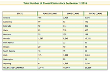
Land Matters updated the Mining Claims Maps to February 15th. Colorado got very active this report period. The beat goes on in Nevada with another 1,099 claims closed the last two weeks.

Here's the totals for closed claims so far this mining year.

2017-02-15.png

To see the new claims just visit your State's Mining Claims Map. :thumbsup:

Heavy Pans
 

Bejay

Bronze Member
Mar 10, 2014
1,026
2,530
Central Oregon Coast
Detector(s) used
Whites GMT
Garret fully underwater
Primary Interest:
Prospecting
It is amazing how miners think claims are all taken and some even go to Ebay looking for a claim to buy. How many claims does a miner want to have?....as the opportunities are almost endless staking and filing your own. I had a miner contact me yesterday and want to know if I had a claim I wanted worked or help working and he even inquired if I would sell a claim. I am amazed that many miners have such a lack of knowledge to do their own. It is all explained on Land Matters and the prospecting opportunities to then seek out good claims is endless. What can I say...other than check out Land Matters and go have some fun!....if you lack a spot!

Bejay
 

crumbaker

Jr. Member
Feb 22, 2016
59
51
Primary Interest:
All Treasure Hunting
Did something change? I could have sworn this used to work like google maps now I can't navigate at all. Constantly refreshing the map and I can't figure out how to zoom properly.
 

OP
OP
Clay Diggins

Clay Diggins

Silver Member
Nov 14, 2010
4,901
14,275
The Great Southwest
Primary Interest:
Prospecting
Did something change? I could have sworn this used to work like google maps now I can't navigate at all. Constantly refreshing the map and I can't figure out how to zoom properly.

Hi crumbaker. I just saw your post, sorry for the delayed response.

The Land Matters maps are nothing like Google maps and never have been. Google uses a set of 19 image files that you are allowed to click/zoom through. Land Matters creates each map from our databases according to which map layers and area you request. You can zoom right in to your area of interest using the zoom box feature without any clicking at all.

The Land Matters maps remember each zoom, move or information request you make so if you don't wait for the map to load before you make another new request the maps will just keep progressing through your requests until it catches up with your clicks. Google maps only remember one request so you could click all day and it won't make any difference to the Google map until a new map is fully loaded.

Treating a Land Matters custom interactive map like a google one click map will produce a map that happily hops around to all your commands and appears to be completely out of control - just what you are describing.

Welcome to the modern world of custom interactive mapping. Land Matters maps do exactly what you request. If you take a little time to learn the more advanced mapping features on Land Matters you will find a rich source of information. You should start by reading the mapping instructions found by clicking the "HELP" button at the top of the map window. You can find the same information on this web page. Land Matters has also produced several videos to help you get better use of the many new features you will find on their maps.

Hope that helps. :thumbsup:

Heavy Pans
 

Bejay

Bronze Member
Mar 10, 2014
1,026
2,530
Central Oregon Coast
Detector(s) used
Whites GMT
Garret fully underwater
Primary Interest:
Prospecting
When I start zooming in on Landmatters maps it goes down a ways but then I get a white screen!

Bejay
 

Goldwasher

Gold Member
May 26, 2009
6,077
13,225
Sailor Flat, Ca.
🥇 Banner finds
1
Detector(s) used
SDC2300, Gold Bug 2 Burlap, fish oil, .35 gallons of water per minute.
Primary Interest:
All Treasure Hunting
the best thing to do is zoom down to about a section on a map. Then turn on the layers you want to apply.
sometimes you have to use the refresh button.
 

OP
OP
Clay Diggins

Clay Diggins

Silver Member
Nov 14, 2010
4,901
14,275
The Great Southwest
Primary Interest:
Prospecting
If you zoom in too close Bejay there is no base map information to see. In the areas around cities and along the coast there is 1 foot resolution but when you are looking in more rural areas there is only 3 foot resolution. Try zooming out one or two steps and you will see more information.

Land Matters could limit the distance you can zoom in like Google maps but so much of the data we host is higher resolution than the stock aerial imagery we didn't want to limit users to just the lower resolution information. :thumbsup:

Heavy Pans
 

winners58

Bronze Member
Apr 4, 2013
1,729
4,058
Oregon
Primary Interest:
All Treasure Hunting
my zoom is backwards on my scroll wheel from all other maps like G-earth and esri
on those maps forward is zoom, back is out, so if I even touch the wheel in mylandmatters will mess it up...
 

OP
OP
Clay Diggins

Clay Diggins

Silver Member
Nov 14, 2010
4,901
14,275
The Great Southwest
Primary Interest:
Prospecting
my zoom is backwards on my scroll wheel from all other maps like G-earth and esri
on those maps forward is zoom, back is out, so if I even touch the wheel in mylandmatters will mess it up...

Just the opposite on my mice. I could change the mouse zoom direction but then everyone else would see the zoom as "backwards". :BangHead:

Unlike those other maps you do have back and forward buttons on the Land Matters maps. If you accidentally go somewhere you hadn't intended just hit the back arrow and you will end up on the previous map extent. No need to start all over like on google or esri. The smart mapping interface can take you back or forwards through the maps you make. :thumbsup:

Heavy Pans
 

Last edited:

Top Member Reactions

Users who are viewing this thread

Top