Old Dog
Gold Member
Springfield,
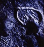
This side of this etching has always held my interest.
When you update the photo be sure to catch as much of the top as possible, the part that still isn't in the photo.
Somewhere in the missing part of your map there is a mine marked and it should be just above The double triangle, The long trail that looks as though it leaves the map Is the main trail. But look closely where the trails seem to join it, there is only one that does, it is on the left. there are two other trails on the right. The distances involved are large as looked at here the things are marked in Leagues and double half leagues. Or double the distance markers.
watch the two trails that almost join up and at that point follow the prominent one 1/2 league to the next major sign. This one will lead you into the mine site probably another 1/2 league to the right.
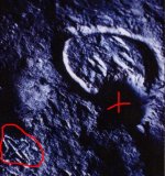
I was intrigued with the upper part of this because the mine cave and cache signs and symbols are almost totally missing from the bottom half of this map. I am also thinking that this thing covers more area than a single fly over will show. A map of this magnitude may cover an area that reaches over a composit thousand miles or more.
An accurate scan and a topo program on the computer will maybe give you a better chance of putting some of this map to use. If need be break it into several sections, it is way to big to be used all at once, and I don't believe it was meant to be looked at in that way.
This map probably reaches from California (on one end) to Eastern Colorado (on the other)
This thing is huge!!
This side of this etching has always held my interest.
When you update the photo be sure to catch as much of the top as possible, the part that still isn't in the photo.
Somewhere in the missing part of your map there is a mine marked and it should be just above The double triangle, The long trail that looks as though it leaves the map Is the main trail. But look closely where the trails seem to join it, there is only one that does, it is on the left. there are two other trails on the right. The distances involved are large as looked at here the things are marked in Leagues and double half leagues. Or double the distance markers.
watch the two trails that almost join up and at that point follow the prominent one 1/2 league to the next major sign. This one will lead you into the mine site probably another 1/2 league to the right.
I was intrigued with the upper part of this because the mine cave and cache signs and symbols are almost totally missing from the bottom half of this map. I am also thinking that this thing covers more area than a single fly over will show. A map of this magnitude may cover an area that reaches over a composit thousand miles or more.
An accurate scan and a topo program on the computer will maybe give you a better chance of putting some of this map to use. If need be break it into several sections, it is way to big to be used all at once, and I don't believe it was meant to be looked at in that way.
This map probably reaches from California (on one end) to Eastern Colorado (on the other)
This thing is huge!!