tayopa, legend or reality ...?

Bandit,

"First, can you tell me anything about the Guayajiro Indians that live in the proximity of Tayopa? I've tried to find them via a Google search, but so far the only results show Guayajiro Indians in Venezuela. Were the Mexican Guayajiros the group that massacred the miners of Tayopa? I have heard various reports that attacking Indians were Pimas, Apaches, Yaquis, or others. As I remember from your earlier posts, the Guayajiros in the area of your Tayopa knew nothing of Tayopa and that your discovery was made independent of any information from them."
__________________________

The people you are asking about are called Guarijio. They are a Sonoran tribe and closely associated with the Mayo people. Their language is Uto-Aztecan.

I would assume that Jose will tell you everything you want to know about the Guarijio. I know something of their history, but believe our friend will have intimate knowledge.

Take care,

Joe
 

Not to worry, Honorable Don Jose. I fully appreciate the uncertainties of cyberspace.

Thanks, Joe, for the clarification/information on the Guarijio Indians. Will try Google again.

Gracias.

Bandit
 

bandit
My friend Real de Tayopa aka Don Jose de la Mancha aka till Eulenspiegel aka Tropical Tramp,

Sorry I've been away so long. Hope you are well and that your plans for developing Tayopa are progressing. Also I have hopes of seeing your book sometime in the future. I realize that you have many irons in the fire (such as monitoring and posting messages here as well as other topics).
~~~~~~~~~~~~~~
AND chasing goils.
***********************************************************************************

First, can you tell me anything about the Guayajiro Indians that live in the proximity of Tayopa?
~~~~~~~~~~
My boo boo for accidentally adding a "Y". Guarijio. =- Thanks my onry cactus jumper friend. heheh
***********************************************************************************
Were the Mexican Guayajiros the group that massacred the miners of Tayopa?
~~~~~~~~~~
The Guajiros were/ are a peaceful group. why they were rounded up by the Jesuits.
************************************************************************************

your discovery was made independent of any information from them.
~~~~~~~~~~~~~~

True, but they did help to confirm it later.
*************************************************************************************

Second, have you been able to recover any artifacts from Tayopa?
~~~~~~~~~~~~~~~~~
Effectively from the Jesuits, no, except for a few graves of the Padres. You must understand that this a very delicate operation, I cannot do any excavation until the permits are in my hot lil hands. If anything held it up, or removed my rights, then I would merely be handing this data on a silver platter to whomever was responsible for removing me. No permit,. then it will remain hidden for another 400 years. I will then open it up on my next reincarnation. snicker.
*************************************************************************************.
Does the area show evidence of past human habitation? Is there evidence of past mining? Are there trails leading into the site?
~~~~~~~~~~~~~~~~
The area is crawling with mining efforts, bothlarge and small.- comparatively speaking.
*************************************************************************************

Third, do you know anything about Charles Kenworthy? Are his books reliable?
~~~~~~~~~~~~~~~~
I believe that Gollyum has answered that in his usual fine manner. I hope that he is taking good care of my white Land Rover.
**************************************************************************************
Did you use treasure signs and symbols in your field work to find Tayopa?
~~~~~~~~~~~~~~~
NOPE, none.
**************************************************************************************

Last, I've really appreciated seeing the photos of the Tayopa site that you've posted in the past. I've tried without success to view the area using Google Earth. Do you have any overhead aerial shots of your Tayopa or satelite shots of reasonably good resolution that you could share?
~~~~~~~~~~~~~~~!
Yes --->http://i228.photobucket.com/albums/ee290/Tayopa/TAYOPAparamo-1.jpg
]
*************************************************************************************


Don Jose de La Mancha
 

Come on JC,

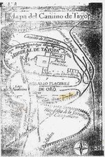
What about that nice little map you showed us many times before?

Mike
 

Estimado Don Jose,

Thanks very much for your answers to my several questions. In particular, muchas gracias for the satelite photos with the the markups showing some of the Tayopa features indicated in the Dobie map. Very interesting. Thanks also to Mike for using your powers of persuasion with said RdT to obtain the additional enhanced posting.

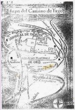
Naturally enough, however, this does raise added questions. First, if the Guaijiro Indians didn't massacre the Tayopa miners, which tribe did? Second, the Dobie map shows caminos or roads going into and out of Tayopa. Don Jose, did you see any evidence of roads or, at least, old trails leading to your Tayopa?

Lastly, Don Jose has already answered this, but has anyone in the group run across Adrian Westwood, author of Jesuit Gold, a Treasure Hunter's Guide to Tayopa? As I understand, he's looking for Tayopa #1 and/or Tayopa #2 (by Don Jose's reckoning) in the Guaynopa canyon area. As far as I can tell, he and Don Jose are the two living people who have spent the most time in the field in Mexico actually seeking Tayopa. He seems to have gone underground. Anyone know anything of his whereabouts?

Don Jose, as I remember, you've read Jesuit Gold. Was it accurate or did it agree with most of your research/experience?
 

The middle map is hard to read sideways.

tayopa.jpg

Cool stuff.
 

Good afternoon Bandit: you asked -->

First, if the Guaijiro Indians didn't massacre the Tayopa miners, which tribe did?
~~~~~~~~~~~~

The guajiro's as a tribe, didn't, but individuals did join the other tribes Pimas, Yaquis, Opatas, Onavas, Chinapaas, and on. There were Apaches involved also.
*********************************************************************************
You also posted -->

, the Dobie map shows caminos or roads going into and out of Tayopa. Don Jose, did you see any evidence of roads or, at least, old trails leading to your Tayopa?
~~~~~~~~~~~~

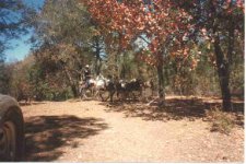
Yes, they exist exactly as Dobie's map indicates. However, the names Yoquivo and Arisiachi were transposed, typical Jesuit trick.. The enclosed picture #1, shows a mule train going down the Yoquivo trail to the rio Mayo.

The trail to Espobachi is to a Spanish mining camp, even the present Indians don't know of this..

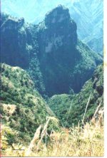
Incidentally, this is the spot where the griz bear, EL TORO, used to attack the mule trains when they crested the climb out of the barranca. Also this is where the gentleman blew the cow horn to listen for the three echos for Tayopa, more on this. At the crossing of the two trails one goes south down into the Paramo Barranca by way of a well constructed trail to the South, up the visible fault on the far side, and behind the far hill to a pole road, then down into Tayopa on the right. . Picture #2.
**************************************************************************************
You also asked -->

Don Jose, as I remember, you've read Jesuit Gold. Was it accurate or did it agree with most of your research/experience?
~~~~~~~~~~~~
Basically yes, but he favors Guaynopa. Actually it is a series of anecdotal stories and misc data, most of which is useful. A good little pocket manual.

More questions?


Don Jose de La Mancha
 

Attachments

  • 1 Yoquivo trail.jpg
    1 Yoquivo trail.jpg
    30.8 KB · Views: 1,442
  • 2 Paramo.jpg
    2 Paramo.jpg
    44.2 KB · Views: 1,379
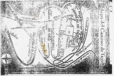
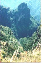
Good Afternoon: This is a picture of the "mesa chico" as shown on Dobie's map. Paramo, left center. It is just to the left of the "D" of De Oro

Don Jose de La Mancha
 

Attachments

  • .Dobie\'s.jpg
    .Dobie\'s.jpg
    50.4 KB · Views: 1,538
  • 3 mesa Paramo.jpg
    3 mesa Paramo.jpg
    44.4 KB · Views: 1,368
Muy interesante. Thanks again, Don Jose.

OK, as I understand it, based on your last photo, we're looking westward from the top of the of the ridgeline of the montana de la Serrania del Campanero. We can't see most of the mines of Tayopa or the capilla because the large promontory blocks them out, but the Paramo placer mines (Oroche, El Senor, Remedios) should be below and to the right of the Mesa chico. Correct?

Questions, always more questions. Are you hoping to revive/redevelop the Tayopa mines, or are you hoping to find the hidden bullion cache? Or both? Among other things, Dobie says, "According to this document, the Tayopa mines at the time of the great Indian uprising of 1646 had not exported any silver for years, though they had been in bonanza from 1632." If true, it sounds as if further development of the mines might be difficult at best, and going for the treasure cache might be the better opportunity.

Thanks also for the pieces about the grizzly bear and the fellows with the cow horn. Is this the bear that was supposed to have a star on its chest and was purported to be unkillable.

Regarding the gentlemen with the horn. My understanding is that your Tayopa is not near where Dobie and Ruggles thought they found Tayopa at Guadalupe de Santa Ana, but the two locations are not that distant either. Yet Dobie says that he encountered the three men with the cow horn it was a "long, long way from where Ruggles and I located Tayopa." So does the cow horn work at your Tayopa?
 

Evening Bandit: you posted-->

we're looking westward from the top of the of the ridgeline of the montana de la Serrania del Campanero
~~~~~~~~~~~~~~~
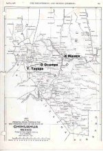
No, you arer looking south from the junction of the Yoquivo and Arisiacha trails, where El Toro, The star marked Grizz lived. Check your map. See attach #1. Map of Chihuahua,1908. D of attach no 2
*********************************************************************************
You posted --.

the Paramo placer mines (Oroche, El Senor, Remedios) should be below and to the right of the Mesa chico. Correct?
~~~~~~~~~~~
Correct. on the placer, but ---.they like to the left
*********************************************************************************
You posted -->

Are you hoping to revive/redevelop the Tayopa mines, or are you hoping to find the hidden bullion cache? Or both
~~~~~~~~
That depends entirely how the cards are stacked or passed. Tayopa itself, consists or two huge stopes, one above the other, only separated by only a small bit of rock floor on the upper one.
**************************************************************************************
You posted -->

My understanding is that your Tayopa is not near where Dobie and Ruggles thought they found Tayopa at Guadalupe de Santa Ana, but the two locations are not that distant either.
~~~~~~~~~~~~~~~~
You are correct, Dobie never set foot on Tayopa. Yes, they are some 50 - 60 miles apart. N/S.
*************************************************************************************
You posted -->

So does the cow horn work at your Tayopa?
~~~~~~~~~~~~~~~~
Theoretically yes, never tried it, but look at the aerial,photo #2. Noise originating at A goes to the bend of the Paramo placer B, some returns, first echo. Other sound energy continues to point C in Tayopa.there it returns back the same path to the point of origin. second echo. Some continues to the northern face of the Tayopa barranca D, then returns back the same path to the origin, third echo, but of a higher pitch..

Anything else, except the location of "X"..

Don Jose de La Mancha
 

Attachments

  • .jCerro.jpg
    .jCerro.jpg
    55.6 KB · Views: 1,328
  • ECHO.jpg
    ECHO.jpg
    91.7 KB · Views: 1,305
Good evening, Don Jose,

Thanks for the geography and orientation lesson. Just to clarify, using your photo marked with mesa chico, we're at position D as shown on the Dobie map marked with A,B,C, and D. If this is correct and we're looking south, can we see the position of the iglesia or capilla in the photo, or is it behind the promontory?

Again, just for purposes of orientation and perspective, how far away is position D from mesa chico? The Dobie map is good, but there's no scale shown and terrain features are minimal. It's amazing to me how you were able to find and recognize Tayopa using the Dobie map, but I assume there were other sources as well. How far away is the nearest human settlement from Tayopa?
 

Evening Bandit:

You asked -->
"using your photo marked with mesa chico, we're at position D as shown on the Dobie map marked with A,B,C, and D. If this is correct and we're looking south, can we see the position of the iglesia or capilla in the photo, or is it behind the promontory?
"
~~~~~~~~~~
You are at position "A". The Capilla lies to your right, itis not visible in the photo.
*****************************************************************************************
You asked -->
"how far away is position D from mesa chico"
~~~~~~~~~~~
West about 1000 air meters
***************************************************************************************
You asked-->
"It's amazing to me how you were able to find and recognize Tayopa using the Dobie map"
~~~~~~~~~~

I didn't use that map at all. I only found that it was accurate after finding Tayopa while comparing data.
I assumed that a map published in a popular novel would be useless, or it wouldn't have been published.

I also assumed that it probably had been followed by many others, and if it had validity, they would have found Tayopa.
****************************************************************************************

You asked -->
"How far away is the nearest human settlement from Tayopa?
~~~~~~~~~
Shall we say 800 meters in plain sight? There is a lumber mill overlooking the N/W corner of the Tayopa
Barranca.

Don Jose de La Mancha at your service Bandit, ask away.
 

Good evening again, Don Jose.

This is all great stuff. Again, muchisimas gracias.

So, if position D is about 1000 meters (as the crow flies) from mesa chico, I'm assuming that position A is a little more than 1000 meters from mesa chico. Correct?

One more seemingly strange question. What kind of wood does the lumber mill process? Pine? Oak? Or something else? Just interested to get a feel for the surrounding landscape.

Also, what can you tell us about the Paramo Placeres de Oro? Are they still commercially viable, or have they played out? Do they have any part in the Tayopa story? Are they in your Tayopa plans, and do they hold any interest for you?
 

Bandit,

I believe I can offer a pretty good answer to your tree question.

The most likely tree being cut at a local sawmill, would be pine. There could also be oak, but primarily they would be cutting pine.

Even though there have been government regulations, they have never been enforced.......that I know of.

The usual practice is to clear cut an area around the sawmill and then close it down. No new growth trees would be in the lands future, because no new trees are planted. The erosion of the hills is severe, causing new roads to be constantly graded over the land.

It is not a pretty picture, or at least it wasn't. Perhaps things have changed.

The Guarijios work the mills, but they mostly get the less important jobs. They stack and load the lumber and burn the sawdust generated by the milling process.

Jose probably has information that is a bit more current than mine.

Take care,

Joe
 

Joe,

Thanks for the post regarding the logging in proximity of Tayopa. Makes sense to me.

I remember a line from Apache Gold where Dobie begins to write about Tayopa and says that Pimas in the Sierra Madre would cut down large pines just to get a single squirrel. Your comment about deforestation is depressingly evident worldwide.

In his search for Tayopa, Dobie also mentions a particular tree, the guerigo (Populus wisilizeni) that he says was/is rare in Mexico. Other sources say it is common. Does anyone know of it?
 

Bandit,

You are talking about the Fremont Cottonwood tree. I believe it is found in that country, but will tell you for sure this evening. (The tree is found in northwest Mexico).

In any case, I doubt it's still a viable clue to finding the Tayopa Mine. You have done your homework here, as that clue by Dobie seemed pretty casual. As I recall, it came from a man named Custer???..(Make that Custard)

Jose must have looked for those two, really thick, guerigo trees. Let's see if he comes up with an answer.

Take care,

Joe
 

Good evening Bandit: you asked -->

So, if position D is about 1000 meters (as the crow flies) from mesa chico, I'm assuming that position A is a little more than 1000 meters from mesa chico. Correct
~~~~~~~~~

Sorry, no. A to the Mesa chico is approx 3 - 400 meters horizontally
****************************************************************************************
You also asked -->

What kind of wood does the lumber mill process? Pine?
~~~~~~~~~~~~~

Correct, pine, with occasional hardwood..
***************************************************************************************
You also asked -->

what can you tell us about the Paramo Placeres de Oro? Are they still commercially viable, or have they played out? Do they have any part in the Tayopa story? Are they in your Tayopa plans, and do they hold any interest for you?
~~~~~~~~~~~~
They prob have been re enriched. They are inside a very narrow arroyo with steep sides, almost inaccessible today. Yes they are in my plans,.but I have been very careful to not to attract any attention to the area, not ready just yet..

Don Jose de la Mancha
 

CJ mi buddy: you posted-->

The most likely tree being cut at a local sawmill, would be pine. There could also be oak, but primarily they would be cutting pine.

Even though there have been government regulations, they have never been enforced.......that I know of.

The usual practice is to clear cut an area around the sawmill and then close it down. No new growth trees would be in the lands future, because no new trees are planted. The erosion of the hills is severe, causing new roads to be constantly graded over the land.
~~~~~~~~~~~~~~~~~

CJ, you are basically correct, however clear cutting is no longer allowed.The trees to be harvested are first marked.
***************************************************************************************
You also mentioned -->

You are talking about the Fremont Cottonwood tree. I believe it is found in that country, but will tell you for sure this evening. (The tree is found in northwest Mexico). In any case, I doubt it's still a viable clue to finding the Tayopa Mine.
~~~~~~~~~~~
You are correct, almost every arroyo has some. And no. I did not look for them. The cerros chapos are there though.

Don Jose de La Mancha
 

Top Member Reactions

Users who are viewing this thread

Back
Top