The Peralta Stone Maps, Real Maps to Lost Gold Mines or Cruel Hoax?

Do you think the Peralta stone maps are genuine, or fake?


  • Total voters
    121

somehiker

Silver Member
May 1, 2007
4,365
6,428
Primary Interest:
All Treasure Hunting
Shafts in mines that followed veins of ore could go in all directions, even straight up. And it's been said the Mexicans didn't often remove any more rock than was necessary in order to extract that ore, with the result being that their old mines were not much more than "rat holes". So I guess what Bill has described is possible, but I have to wonder how what must have been a rather heavy slab of stone would have been secured in place. The " upper trail stone " of the set at the SMM has a deliberately beveled edge. Perhaps it was originally meant to be held in place somewhere via that bevel ?

View attachment Mitchell 6.bmp
 

markmar

Silver Member
Oct 17, 2012
4,122
6,269
Primary Interest:
All Treasure Hunting
Wayne

The " upper trail " stone slab could be a part of another map in the fields , somewhere in the "cross " map region and close to the " heart " symbol from the CP map .
 

somehiker

Silver Member
May 1, 2007
4,365
6,428
Primary Interest:
All Treasure Hunting
Wayne

The " upper trail " stone slab could be a part of another map in the fields , somewhere in the "cross " map region and close to the " heart " symbol from the CP map .

Marius:

I've seen no reason to believe so, despite my own theory that the stone map cross and the CP drawing apply to the same location as the beginning of the "trail" shown on the two trail stones. I haven't seen anything which I would consider a "larger map" where I have chosen to search, and don't see the petroglyph site that you have shared on the other thread as being related to my own location....at present.
Considering the claims by RG and the Tumlinson family, the Museum Stones are not what Travis found or searched with, and that the two trail stones are also larger and a different color than what T.T. had fabricated, it's possible that those smaller stones he found are related to some of the petroglyph sites out there. Once we've seen them all, I and others may be able to recognize some or all of what they show, and suggest any likely connections.
 

Last edited:

markmar

Silver Member
Oct 17, 2012
4,122
6,269
Primary Interest:
All Treasure Hunting
Wayne

Yes , I believe so how the Cross and the CP maps should be applied in the lower stone trail map . Could this be considered a fold of the upper trail over the lower ?
Now , about what stone maps T Tumlinson had fabricated , my opinion is how the smaller stones are the fake .
The petroglyph is close to the main Peralta's mines site and camp , but little ( in sight } afar of what it describes .
 

Last edited:

somehiker

Silver Member
May 1, 2007
4,365
6,428
Primary Interest:
All Treasure Hunting
I don't think so Marius, based on what I have found out there that seems to closely match much of what is on those two stones. All of those features are visible from places at ground level though, with topo maps or sat views being of no use to myself whatsoever. Topo maps aren't detailed enough, nor would they show what the markings on the stones and CP represent IMO. And Sat views are straight down views which cannot show markings and patterns only found on vertical surfaces. They also cannot show what is in the shadows, where some of what I have located is situated. I have found nothing within my current search area which suggests a connection to the Peraltas or to the LDM.
It will be interesting to see what the experts have to say about the five smaller stones. You might be correct in that opinion.
 

sgtfda

Bronze Member
Feb 5, 2004
2,351
3,889
Mesa Arizona
Shafts in mines that followed veins of ore could go in all directions, even straight up. And it's been said the Mexicans didn't often remove any more rock than was necessary in order to extract that ore, with the result being that their old mines were not much more than "rat holes". So I guess what Bill has described is possible, but I have to wonder how what must have been a rather heavy slab of stone would have been secured in place. The " upper trail stone " of the set at the SMM has a deliberately beveled edge. Perhaps it was originally meant to be held in place somewhere via that bevel ?

View attachment 1430843

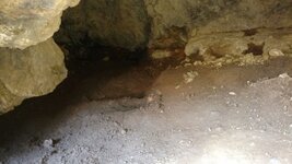
Speaking of Rat holes. Follow the Garman map to the end. A old well hidden silver mine. Whoever dug it went through a lot of trouble to fill in the entrance to hide it. This mine is exactly as you described Wayne. ImageUploadedByTreasureNet.com1490503899.105269.jpg

In episode 2 of the Legend show you see Deal wiggle into a snake hole near the heart stone. Woody and I noticed it was filled in with loose dirt. The show moved on to The next legend. We returned 2 years later to investigate. You see the map did lead to a mine.
 

Last edited:

somehiker

Silver Member
May 1, 2007
4,365
6,428
Primary Interest:
All Treasure Hunting
So, do you think it's likely that same someone made the Peralta Tesora Mappa that you used in the show, Frank ?
Is the mine where the arrow points into the heart on the map ?
If not, there could be something else under that heart.
 

sgtfda

Bronze Member
Feb 5, 2004
2,351
3,889
Mesa Arizona
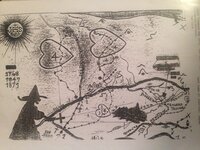
Yes I do Wayne. I found 6 sites using that map. The mine is exactly where the arrow points. After finding the other locations I went to that spot to see what was there. Found the heart stone. During filming Woody found the mine about 20 ft from the stone.
 

somehiker

Silver Member
May 1, 2007
4,365
6,428
Primary Interest:
All Treasure Hunting
So, is it a "Peralta Map", do you think....showing some of their mines ?
Did you find anything where the dark shaded arrowhead is on the map ?
Might be a flint or obsidian (apache tears) deposit.
 

sgtfda

Bronze Member
Feb 5, 2004
2,351
3,889
Mesa Arizona
The dark shaded arrow under 1847 points to the location of the mine and heart stone. The map is marked Peralta. The heart area covers a huge copper deposit
 

somehiker

Silver Member
May 1, 2007
4,365
6,428
Primary Interest:
All Treasure Hunting
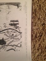
I've had that one in my own collection for a few years.....one of the Das Lucas ( Jean Paul Gagne ) maps that showed up well after the stone maps were publicized.
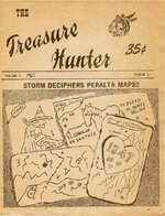
That priest silhouette might have been based on Storm's 1967 Stone Map article.....

storm-deciphers-peralta-stones.jpg

Overall, the map kinda reminds me of one of the maps from the Reavis fraud case as well.
 

Last edited:

sgtfda

Bronze Member
Feb 5, 2004
2,351
3,889
Mesa Arizona
There is a earlier version of the map without some of the stone map stuff along with other Jesuit marked maps. The story I heard was they originated from a old Canadian Jesuit priest.
 

sailaway

Hero Member
Mar 2, 2014
623
815
Primary Interest:
All Treasure Hunting
Interesting Map, areas I have focused on in my search are covered and appear to be drawn by someone who knew more of that area than has been posted to date. The Heart is also the same heart I originally posted when I started my search and posted in my Mina Virgon Survey.
 

Last edited:

Top Member Reactions

Users who are viewing this thread

Top