The Peralta Stone Maps, Real Maps to Lost Gold Mines or Cruel Hoax?

Do you think the Peralta stone maps are genuine, or fake?


  • Total voters
    121

Ellie Baba

Hero Member
Mar 7, 2005
527
54
Laveen, AZ
Detector(s) used
Tesoro Lobo
cactusjumper said:
Ellie,

There are so many faces in your picture, I decided to only highlight these:

DSCF2510_Desktop_R_.jpg


Do you believe they are man-made? Attached is photo of same face (right side) looking northwest, base outcrop with window sight is AA of crescent.


See you soon,

Joe


Joe,

I am not sure, but it wouldn't surprise me. I have found numerous techniques of this art form all over the area. Just take a closer look at some of the cliff sides and outcroppings and maybe you will see what I am talking about. There are so many examples and I can't explain (as of yet) who even planned and created all of this art and how long it would have taken them to do so.

I have tried through the years to avoid working in this area as I have too much on my plate as it is. The crescent moon kept messing with me so I have tried to focus on it and ignore the other stuff.

The crescent is tied to the stone maps as it is located where the maps have indicated, along with the R-rock sara. This area is outside the box and I ask the question why.
See you soon,

Ellie Baba
 

gollum

Gold Member
Jan 2, 2006
6,729
7,598
Arizona Vagrant
Detector(s) used
Minelab SD2200D (Modded)/ Whites GMT 24k / Fisher FX-3 / Fisher Gold Bug II / Fisher Gemini / Schiebel MIMID / Falcon MD-20
Primary Interest:
All Treasure Hunting
cactusjumper said:
Ellie,

My guess is that someone is monitoring this Forum and complained to Jeff. I could be wrong, but it seems likely. Maybe in the future you could just ask Jim for permission and then post the results of that request. I think he would be happy to provide you permission....Just wants to be asked. :dontknow:

Take care,

Joe


Joe,

I think you are absolutely correct.

Ellie,

I also agree that if you ask Jim to use his pics in a not-for-profit fashion, then he most likely won't mind your using them (as long as you give credit).

Mike
 

cactusjumper

Gold Member
Dec 10, 2005
7,754
5,389
Arizona
Mike,

Thanks for clearing that up. I have always said that that Jim fella is a prince. Of course, rather than get the moderators involved, it would have been less of a hassle to just tell Ellie he had stepped over some line.

Ellie is one really nice man. Don't believe he would say a cross word if someone cut off his toe. :dontknow: A quiet word would have been best......IMHO, but you know Jim better than I.

Hope you make it to the Rendezvous.

Take care,

Joe
 

Ellie Baba

Hero Member
Mar 7, 2005
527
54
Laveen, AZ
Detector(s) used
Tesoro Lobo
Hi All,

See attached photograph below:

Take a look at the reclining dude; do you see what he is looking at? The cliff side has all kinds of symbols, signs and people all over it. Take your time and you will begin to recognize letters, numbers, boxes, etc. Once you train your mind to recognize the techniques used to create these sara monuments you will see these symbols on other sara monument locations. This is the most difficult area to teach individuals to recognize. Time in the field can take hours to three days, but once they actually see what is there they usually freak out and become believers.

More later,

Ellie Baba
 

gollum

Gold Member
Jan 2, 2006
6,729
7,598
Arizona Vagrant
Detector(s) used
Minelab SD2200D (Modded)/ Whites GMT 24k / Fisher FX-3 / Fisher Gold Bug II / Fisher Gemini / Schiebel MIMID / Falcon MD-20
Primary Interest:
All Treasure Hunting
I have always said that that Jim fella is a prince.

Joe,

That quote speaks to me. I can't say what it says because this is a public forum! HAHAHA :laughing9: :laughing9: :laughing9: :laughing9:

Best-Mike
 

shadow hunter

Greenie
Oct 11, 2010
17
0
mesa, az
could it be that there are other maps somewhere leading to these stones, but just by chance these were found by accident first? and if that is the case, then could it be safe to say that these stones may very well be maps to other maps? i mean the witch stone is believed by many to be a map to the other stones. someone took the time to make these maps, if these are not a hoax, then someone went through a lot of trouble to make sure that these maps would stand the test of time. The only reason for that is because whom ever it was that made them, knew that they would be untouched for a long period of time. come on, common sense would deem that any person who was planning to return to these mines would have taken the information home with them and kept it hidden away because they planned to return. whoever made these maps knew they were not coming back, they knew this was the only way to keep the mine alive. But then that begs the question, why all the hidden clues, why not just give detailed instructions? because of that question the only logical answer would be that they were meant for some one specific, someone that knew the area, but had never been to the mines. They were not left by mexicans, so they could send their crews up later to mine the area, they would have kept all the info close, not make them on slabs of stone for anyone to find. i believe that these stones are real, maybe because i love the hunt of the treasure, or maybe because i have not been pursueded otherwise. I don't think those stones were just descarded after use, they most likely would have had some damage from being dropped or thrown. besides, why would you get ride of them there on a hill top, most likly they would have been discarded at the location or at camp when they stopped. That area was not a place they would have camped up for the night, no water, no shade, rocky ground, and in plane view of the apaches. those stones were left there on purpose.
 

Loke

Hero Member
Mar 24, 2010
589
1,383
Republic of Texas
Primary Interest:
All Treasure Hunting
by ellie baba
Take a look at the reclining dude
Ellie - does that mean that (in your opinion) the 'reclining dude' is man-made?
(I had hard enough time getting _anything_ at all out of it ... - and surely, at some other time-of-day, from the same position - it would not look like a 'dude' at all - actually, imho it doesn't even look like 'dude' now))
 

Ellie Baba

Hero Member
Mar 7, 2005
527
54
Laveen, AZ
Detector(s) used
Tesoro Lobo
Loke said:
by ellie baba
Take a look at the reclining dude
Ellie - does that mean that (in your opinion) the 'reclining dude' is man-made?
(I had hard enough time getting _anything_ at all out of it ... - and surely, at some other time-of-day, from the same position - it would not look like a 'dude' at all - actually, imho it doesn't even look like 'dude' now))

The reclining dude structure is an outcropping of rock that has been enhanced by the hands of man. Originally the structure was chosen by the artist in charge because he recognized that it could be modified to look like a reclining dude. The key to this sara is the sky window, an important sign (eye catcher) that instructs the individual to proceed to and search the area for other signs.

The artist's primary intent is to point out to the searcher which way the figure is looking, in this case towards the upper cliff where the written information can be found. This reclining dude is the AA section of the crescent moon looking towards the west. You are right in saying that he doesn't look like a reclining dude in the true sense. This art form was designed to be very subtle in appearance as it was not intended to be recognized by the masses. Hope this sheds some light on the subject.

Later,

Ellie B
 

Ellie Baba

Hero Member
Mar 7, 2005
527
54
Laveen, AZ
Detector(s) used
Tesoro Lobo
Hi All,

I have attached an interesting photograph that depicts a kissing couple. He is standing on the left and is wearing a helmet typically worn by a Chinese, Japanese or Mongel type warrior. She is not as tall and you can see that her arm is around him as they embrace, their lips just touching.

This couple is located just west of the "AA" portion of the crescent moon and the lighting is just
about perfect so as to recognize their forms. This is a typical scene that I have located around many of the sara monuments. They depict many of the emotions that we still deal with today; love, fear, authoritative moments, congregations of folks in worship (friendships) which also depict women holding their babies. Angels, demons, and all kinds of animals and so much more, especially some of the larger murals found on the larger cliff sides that are just breathtaking!

I have finally discovered how to make these sara come to life so that soon everyone will be able to see some of the finest art forms ever known (actually lost) to man. More on this subject later. I have learned so much in just the last few weeks working with the crescent. The company geologist and I are returning with a few close friends to document the geomorphology of this gigantic sara depicting this amazing crescent as we have found it to represent an ancient type of GPS (Global Positioning System) its accuracy has been shown to locate an area within a twenty foot diameter circle! My Garmin Colorado model will normally get me within eight feet! I am pumped up people, I am beginning to see the true picture here.

Later,

Ellie B
 

Ellie Baba

Hero Member
Mar 7, 2005
527
54
Laveen, AZ
Detector(s) used
Tesoro Lobo
Hadji009,

I knew someone would see that darn poodle sooner or later. Really though, the poodle has nothing to do with the prize. At least you have begun by recognizing a poodle, for I started the same way. Spend a number of hours with a photograph (like the one above) and you will find all kinds of stuff; most of the time you will dismiss what you see. Then one day you will remember something you saw and soon find yourself looking at the same photo to convince yourself that what you see isn't really there and whoops! There is so much more hidden in the photo than you realize. Its supposed to be a secret, husshhh! We were not meant to actually see these marvels, the magic swarms the senses, but we rush back into reality thinking this just can not be true.

Spend some time looking at the photograph and you will begin to recognize the techniques used by the artist's and you will discover the art form. Be patient and remember not to tell anyone what you see... or they may think you have lost your marbles. Been there, done that, no fun. My partners and friends have seen the the truth hidden right before their eyes and they believe. You should talk to our geologist, a true convert and still my biggest critic. Jack's attention to detail concerning these creations is amazing. I have learned so much about geomorphology and the tampering hands of men I have been able to recognize other techniques that I had never thought of using to help identify a sara monument site.

I will share some of these techniques used to create the crescent moon. The architects were cunning and masters of this art form. Simply magnificent!

Keep on looking hadji009 and keep me posted.

Ellie B
 

hadji009

Hero Member
Dec 29, 2008
711
193
illinois
forgot to enclude the tail. maybe it is older thay you think,maybe it is a afgan hound and he chased off this lion. thanks brent
 

Attachments

  • DSCF2510 [Desktop Resolution]lion.JPG
    DSCF2510 [Desktop Resolution]lion.JPG
    108.6 KB · Views: 460

Ellie Baba

Hero Member
Mar 7, 2005
527
54
Laveen, AZ
Detector(s) used
Tesoro Lobo
Hi All,

Attached is a photograph of the southeastern slope of the Superstition Mountain range as see from the crescent moon (standing by one of its components; AA). Notice the number of steps going up the slope towards the sara located on its summit, lets say 5 or 6 depending which way you are going.

While standing in the viewing corridor looking at the crescent do an about-face and look towards the steps and you will notice a couple of them are hidden below the contour of the terrain as we have moved south and our elevation has decreased. What does this all mean? The witch or priest on the Priest Map is standing on a certain number of steps... could this be a coincidence?

Ellie B
 

Ellie Baba

Hero Member
Mar 7, 2005
527
54
Laveen, AZ
Detector(s) used
Tesoro Lobo
Hi All,

Yesterday I took this photo of the crescent moon sara area. Can you recognize the area where the crescent will appear? Check out the cliffs very carefully and see if you can locate the symbols that are depicted on them.

Back to day two of Rondezvous!

Ellie B
 

Attachments

  • DSCF2708_AC_CM-text [Desktop Resolution].jpg
    DSCF2708_AC_CM-text [Desktop Resolution].jpg
    169.1 KB · Views: 438

Springfield

Silver Member
Apr 19, 2003
2,850
1,383
New Mexico
Detector(s) used
BS
Ellie Baba said:
Hi All,

Yesterday I took this photo of the crescent moon sara area. Can you recognize the area where the crescent will appear? ....

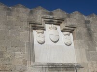
Crescent you say? Here's a crescent picture I took a few days ago in Rhodes, Greece, where the Knights Hospitallers of St. John established their headquarters back in the early 1300's. I wonder if this crescent relates to your crescent?
 

Attachments

  • coatofarms.jpg
    coatofarms.jpg
    203.4 KB · Views: 438

Ellie Baba

Hero Member
Mar 7, 2005
527
54
Laveen, AZ
Detector(s) used
Tesoro Lobo
Hi Springfield, November 01, 2010

Historically correct as I see it to include other secret organizations according to written historical works related to the subject. Check these photographs out. I have also provided a link to the site:

http://knol.google.com/k/sarmatian-persian-king-s-gold-necklace-amulet-1-century-bc-2-century-ad#The_Gold_Necklace_by_itself_is_also_attributed_to_Pleiades_Star_Cluster_(E2)(80)(93)_a_well_known_celestial_and_mythological_sig

This information is critical and points to the secrets of the ancients and these legends were passed on through the ages in many ways to include the stone maps. The Templar/Jesuit/Masonic factions are all tied together as they are so well interwoven throughout history.

As far as I am concerned the Stone Maps are 100% authentic maps to lost treasure. I located the crescent moon by following the directions implied by using the stone maps in the correct geographic area as the maps will only work in one location. The depository site is hundreds of years older than the stone maps themselves.

More on this later,

Ellie B
 

Ellie Baba

Hero Member
Mar 7, 2005
527
54
Laveen, AZ
Detector(s) used
Tesoro Lobo
Hi All,

Once in a while, when you least expect it, a number of things will suddenly fall into place. What did not make sense months ago now makes perfect sense. I posted a number of questions relating to sacred geometry; Phi = the golden mean, and phi which identifies either a latitude or longitude depending on its use over land or sea.

Calculations often represent angles by small letters of the Greek alphabet, and that way latitude will be represented by λ (lambda, Greek L), and longitude by φ (phi, Greek F). Here is how they are defined.

PLEASE NOTE: Charts used in ocean navigation often use the OPPOSITE notation--λ for LONGITUDE and φ for LATITUDE. The convention followed here resembles the one used by mathematicians in 3 dimensions for spherical polar coordinates.

What that value of a given longitude is depends of course on where we begin to count--on where zero longitude is. For historical reasons, the meridian passing the old Royal Astronomical Observatory in Greenwich, England, is the one chosen as zero longitude.

Except in this case; the stone maps require that zero longitude is the meridian passing through Washington, D.C., USA.

More later,

Ellie Baba
 

Blindbowman

Bronze Member
Aug 15, 2007
2,042
978
Primary Interest:
All Treasure Hunting
Ellie Baba said:
Hi All,

Once in a while, when you least expect it, a number of things will suddenly fall into place. What did not make sense months ago now makes perfect sense. I posted a number of questions relating to sacred geometry; Phi = the golden mean, and phi which identifies either a latitude or longitude depending on its use over land or sea.

Calculations often represent angles by small letters of the Greek alphabet, and that way latitude will be represented by λ (lambda, Greek L), and longitude by φ (phi, Greek F). Here is how they are defined.

PLEASE NOTE: Charts used in ocean navigation often use the OPPOSITE notation--λ for LONGITUDE and φ for LATITUDE. The convention followed here resembles the one used by mathematicians in 3 dimensions for spherical polar coordinates.

What that value of a given longitude is depends of course on where we begin to count--on where zero longitude is. For historical reasons, the meridian passing the old Royal Astronomical Observatory in Greenwich, England, is the one chosen as zero longitude.

Except in this case; the stone maps require that zero longitude is the meridian passing through Washington, D.C., USA.

More later,

Ellie Baba

your correct on how it works but the navigator , has a starting point and then goes from there and when he stops a chain of dot & line,... he then takes a new location fix .. its called old world DR tracking .. LOL .. all you had to do ask ...
 

Top Member Reactions

Users who are viewing this thread

Top