Things For Further Research

OP
OP
M

mdog

Bronze Member
Mar 22, 2011
2,366
4,419
Hey Dog, I read a book called Sailing to Paradise and the author had a theory that the first multinational trading organizations existed in the ancient world and they travelled wherever they could, looking for anything that had some value. He believed that certain designs were used by these multinationals to mark territories and trade routes. I'll check the book out and post the symbols this week.

Here are the symbols.
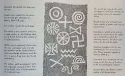
old symbols 700.jpg
 

L.C. BAKER

Silver Member
Sep 9, 2012
3,805
4,643
Nebraska City, Nebraska
Primary Interest:
Other
Those pieces are pretty small. Is there any way the copper strips would have made it easier to find the lead crosses with some type of early 20th century instrument?

I am sure it did as far as metal detecting goes it would make it easier to locate because lead is hard to find below a foot or so deep unless you have a good detector. The fact is that the copper was added later with another direction and distance to travel from the same spot that the lead cross buried slightly deeper told you to travel from, but in another direction based on a certain star and a date with the distance in leagues and fathoms given in Roman numerals. The copper was all stamped not carved and it was different engraving written in plain English distance and heading no code or symbolism. All of the lead pieces have symbolism. It is obvious that the copper strips were left at a different time presumably by a different person do to mortality. This is a great thread keep it up!:thumbsup:

L.C.
 

L.C. BAKER

Silver Member
Sep 9, 2012
3,805
4,643
Nebraska City, Nebraska
Primary Interest:
Other

Interesting, we have two of those symbols used. One is what I first assumed to be a Southern Cross but then found out that it may be a Knights Templar cross which looks pretty much the same. We also have the star or wagon wheel without the rim symbol. In our case it is surrounded by coded letter and numbers as well as some symbols when it is attached to the other map pieces it may also be a sort of pointer to other symbols on those pieces. Not as easy to read as one might think, even with the key. Letters are numbers and numbers are letters, or it may be just what it looks like or it may be a symbol that looks like a letter etc. etc. etc.:BangHead: The XXX's around the symbol are just me hiding the real letters and code, The K's are what is actually there on the piece. K was not coded and given in plain text all through this trail. ??? ,but you get the general idea of how the death star looking symbol is used in our case. Thanks for posting the picture MD!:thumbsup:
L.C.
View attachment 1263355
 

Last edited:

L.C. BAKER

Silver Member
Sep 9, 2012
3,805
4,643
Nebraska City, Nebraska
Primary Interest:
Other
dog, I think it's a huge mistake to say we're more complex today that people were in days gone by. Sure, we have smart phones today, but people's human nature and intelligence don't change, IMO. There's still 360º in a circle and lots of ways of using it, then and now.

I have spent a great deal of time reading personal diaries of gentlemen from the past as I am sure you men have done on your own as well. After a while you begin to realize that their lives were complex in their own way for that time in history. For instance they could be killed while doing about anything, there homes could get robbed, ect. ect. These are all problems we have today too, but we have came a long way in automation...not necessarily surveying technique. I believe that the difference in complexity lies in the population explosion and how it has changed everything, especially the face of the earth. In the field I shut my eyes and think to myself, "what was here in 1849?," when the white man first settled here among the already settled native Indians...... In most of your guy's cases it sounds like the Spanish and others had more hands on in your areas, although they were here too, there just wasn't much for them to find in the way of gold mines and such. At most they would have been interested in the salt of the land at Lancaster, Nebraska and maybe some coal. At any rate, there is not much sign of them being here at all except for what the books say happened.
 

OP
OP
M

mdog

Bronze Member
Mar 22, 2011
2,366
4,419
Here's an excerpt from my post 104.

" Saint John the Baptist's Day is on June 24th. When Columbus landed on Puerto Rico, he named it San Juan Bautista in honor of John the Baptist. The Masons celebrate John the Baptist Day as well as St. John the Evangelist Day just after the winter solstice. I guess maybe the Knights of Columbus would celebrate both holidays too."

That post is about the Mason's celebration of St. John the Baptist Day on June 24th, two days after the summer solstice, and St John the Evangelist's Day on Dec. 27th, five days after the winter solstice. The summer solstice occurs at some time between June 20 and June 22 and the winter solstice occurs at some time between Dec. 20 and Dec. 23.

In one of L.C. Baker's posts he shows a drawing of a cross with the word Capella on it. Here's an excerpt from a book about Pueblo petroglyphs that might also explain why that star might be of interest to the Masons.

The heliacal rising of the star Capella occurred only twice a year and precisely on the date of either the summer or winter solstice. As a practical matter the shaman, after observing the sunrise to the southeast, could walk twenty feet around the corner of the cliff and have an unobstructed view to the mesa to the north. From this new vantage point, he could determine whether the star Capella had made its semiannual appearance.

Here's the link to the book and this editor's note is on page 140.

https://books.google.com/books?id=c...AM#v=onepage&q=symbolism star capella&f=false
 

L.C. BAKER

Silver Member
Sep 9, 2012
3,805
4,643
Nebraska City, Nebraska
Primary Interest:
Other
Here's an excerpt from my post 104.

" Saint John the Baptist's Day is on June 24th. When Columbus landed on Puerto Rico, he named it San Juan Bautista in honor of John the Baptist. The Masons celebrate John the Baptist Day as well as St. John the Evangelist Day just after the winter solstice. I guess maybe the Knights of Columbus would celebrate both holidays too."

That post is about the Mason's celebration of St. John the Baptist Day on June 24th, two days after the summer solstice, and St John the Evangelist's Day on Dec. 27th, five days after the winter solstice. The summer solstice occurs at some time between June 20 and June 22 and the winter solstice occurs at some time between Dec. 20 and Dec. 23.

In one of L.C. Baker's posts he shows a drawing of a cross with the word Capella on it. Here's an excerpt from a book about Pueblo petroglyphs that might also explain why that star might be of interest to the Masons.

The heliacal rising of the star Capella occurred only twice a year and precisely on the date of either the summer or winter solstice. As a practical matter the shaman, after observing the sunrise to the southeast, could walk twenty feet around the corner of the cliff and have an unobstructed view to the mesa to the north. From this new vantage point, he could determine whether the star Capella had made its semiannual appearance.

Here's the link to the book and this editor's note is on page 140.

https://books.google.com/books?id=c...AM#v=onepage&q=symbolism star capella&f=false

Outstanding R & I Mdog! Thanks!:thumbsup:
 

kanabite

Hero Member
May 27, 2006
549
368
southern utah
Detector(s) used
wander aimlessly in circles with camera in hand
Primary Interest:
All Treasure Hunting
.this stuff is very interesting BTW . Questions like where was Orion in the sky way back in time has haunted me before . here is a interesting tangent link for ya. Ya more Tylenol .Monte Alban, Mexico
 

Last edited:
OP
OP
M

mdog

Bronze Member
Mar 22, 2011
2,366
4,419
Here is some more stuff about the Kensington Stone for those of you who want to further research this artifact. It could be that the inscription on the stone might have been used to create another site during the early 1900's. In one of his books, Scott Wolter writes about ten Masons who wanted to buy the site where the KRS was found and build an obelisk there that would have been half the size of the Washington Monument. Steve told me about a place on the U.S.-Canadian border, the International Peace Garden, that was dedicated in 1932. It is centrally located on the border but not close to exact. This garden is supported by several fraternal organizations including the Freemasons. It seems the Masons had an interest in marking the north center of the U.S. There is nothing secret about this stuff and the information can be easily found on google earth and the internet.

I got the location of the runestone from Wolter's book about the hooked X. 45 deg 48' 38" N and 95 deg 39' 38" W.

Here is a Wikipedia translation of the stone and it's the same in Wolter's book, Akhenaten to the Founding Fathers.

"Eight Götalanders and 22 Northmen on (this?) acquisition journey from Vinland far to the west."

"We had a camp by two (shelters?) one day's journey north from this stone."

One days journey is usually considered to be about 20 miles. I was looking for some type of code that could be used so I decided to use 24 hours, a full day, and 4 miles per hour, a distance that can be covered in an hour but probably not maintained. This would make the miles covered in a day, 96. At 352.10 degrees north of the KRS and 96 miles exact is the small town of Waubun. This line from the KRS also runs through Ogema. Both names are from the Ojibwe language. Ogema means "chief" and Waubun means "the east", "the morning", "the twilight of dawn". These two towns are the points that define the east side of an almost perfect equilateral triangle. These two towns would be the new representation of "two shelters one day's journey north of this stone."

"We were fishing one day."

The new site would need a lake or some other body of water where men could fish. The west point of the triangle is on the east side of Apple Lake at a spot where a long line, formed by two points hundreds of miles to the southeast, touches Apple Lake.

"After we came home, found 10 men red from blood and dead. Ave Maria save from evil."

I think this confirms the points of the east line. "red from blood and dead" In Waubun there is a Saint Anne's Cemetery. There are two colors associated with Saint Anne, red and green. "Ave Maria save from evil". There is a Catholic Church in Ogema named Most Holy Redeemer Catholic Church. A redeemer is one who could "save from evil".

"There are 10 men by the inland sea to look after our ships fourteen days journey from this peninsula (or island). Year 1362"

I think this line is to confirm the connection with the KRS. "fourteen days journey from this peninsula" 14 days X 24 hours per day= 336 hours X 4 mph= 1344 miles. There is a peninsula formed on the south side of Apple Lake. If you run a line from the top middle of that peninsula to the place on the eastern Maine border that has the exact latitude of the KRS, you have 1343.77 miles. That spot is also in the middle of Grand Lake which is a pretty good sized lake or "inland sea".

The sides of the triangle are 5.51 miles, 5.47 miles and 5.78 miles.

Here's something else. The latitude at the top of the peninsula at Apple Lake is 47 deg 08' 54". Mark this latitude on the west border of Washington state and the east border of Maine. The distance from Apple Lake to the Maine latitude is 1318 miles. From Apple Lake to the Washington latitude is 1319 miles.

Ogema and Waubun were not established until 1907. This is well after the KRS was found in 1898.

Might seem a little thin but I have no interest in doing any further research on the KRS, so use it if you want.


sdcfia

Silver Member
Sep 28, 2014
3,670
8,913
Primary Interest:
Other
Here is some more stuff about the Kensington Stone for those of you who want to further research this artifact. It could be that the inscription on the stone might have been used to create another site during the early 1900's. In one of his books, Scott Wolter writes about ten Masons who wanted to buy the site where the KRS was found and build an obelisk there that would have been half the size of the Washington Monument. Steve told me about a place on the U.S.-Canadian border, the International Peace Garden, that was dedicated in 1932. It is centrally located on the border but not close to exact. This garden is supported by several fraternal organizations including the Freemasons. It seems the Masons had an interest in marking the north center of the U.S. There is nothing secret about this stuff and the information can be easily found on google earth and the internet.

I got the location of the runestone from Wolter's book about the hooked X. 45 deg 48' 38" N and 95 deg 39' 38" W.

Here is a Wikipedia translation of the stone and it's the same in Wolter's book, Akhenaten to the Founding Fathers.

"Eight Götalanders and 22 Northmen on (this?) acquisition journey from Vinland far to the west."

"We had a camp by two (shelters?) one day's journey north from this stone."

One days journey is usually considered to be about 20 miles. I was looking for some type of code that could be used so I decided to use 24 hours, a full day, and 4 miles per hour, a distance that can be covered in an hour but probably not maintained. This would make the miles covered in a day, 96. At 352.10 degrees north of the KRS and 96 miles exact is the small town of Waubun. This line from the KRS also runs through Ogema. Both names are from the Ojibwe language. Ogema means "chief" and Waubun means "the east", "the morning", "the twilight of dawn". These two towns are the points that define the east side of an almost perfect equilateral triangle. These two towns would be the new representation of "two shelters one day's journey north of this stone."

"We were fishing one day."

The new site would need a lake or some other body of water where men could fish. The west point of the triangle is on the east side of Apple Lake at a spot where a long line, formed by two points hundreds of miles to the southeast, touches Apple Lake.

"After we came home, found 10 men red from blood and dead. Ave Maria save from evil."

I think this confirms the points of the east line. "red from blood and dead" In Waubun there is a Saint Anne's Cemetery. There are two colors associated with Saint Anne, red and green. "Ave Maria save from evil". There is a Catholic Church in
Ogema named Most Holy Redeemer Catholic Church. A redeemer is one who could "save from evil".

"There are 10 men by the inland sea to look after our ships fourteen days journey from this peninsula (or island). Year 1362"

I think this line is to confirm the connection with the KRS. "fourteen days journey from this peninsula" 14 days X 24 hours per day= 336 hours X 4 mph= 1344 miles. There is a peninsula formed on the south side of Apple Lake. If you run a line from the top middle of that peninsula to the place on the eastern Maine border that has the exact latitude of the KRS, you have 1343.77 miles. That spot is also in the middle of Grand Lake which is a pretty good sized lake or "inland sea".

The sides of the triangle are 5.51 miles, 5.47 miles and 5.78 miles.

Here's something else. The latitude at the top of the peninsula at Apple Lake is 47 deg 08' 54". Mark this latitude on the west border of Washington state and the east border of Maine. The distance from Apple Lake to the Maine latitude is 1318 miles. From Apple Lake to the Washington latitude is 1319 miles.

Ogema and Waubun were not established until 1907. This is well after the KRS was found in 1898.

Might seem a little thin but I have no interest in doing any further research on the KRS, so
use it if you want.


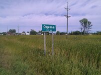
For anyone who wants to run with this, here's what Ogema looks like:

ogema mn.jpg
 

adtofca

Banned
Jan 22, 2016
88
102
California Sun
Detector(s) used
minelab thingy
Primary Interest:
All Treasure Hunting
all the math makes a brain ache . Knights of Pythias used many symbols and you are seeing some of these that they used . be back later to
explain . i have a headache now from the math .
lol
 

OP
OP
M

mdog

Bronze Member
Mar 22, 2011
2,366
4,419
all the math makes a brain ache . Knights of Pythias used many symbols and you are seeing some of these that they used . be back later to
explain . i have a headache now from the math .
lol

I know your pain. :BangHead:
 

OP
OP
M

mdog

Bronze Member
Mar 22, 2011
2,366
4,419
I never paid any attention to cemeteries until I read New Mexico Confidential. Steve's friend, Jim Weaver, gave some good things to look for in cemeteries.

I was lucky to have some clues that directed me to a cemetery, but what would you look for if you don't have a manuscript or a carving to guide you to such a place? I'll list a few things that I have found, that you can look for in the county you live in. I'm not saying it's gonna work for you, but it's something you can check out close to home. Maybe some of the other members will add some things.

1. Check out the map collections at your local library and look for county maps from the late 1800's. Try to find the type of map that shows towns and place names instead of the maps that show property lines and owner names. Find all the cemeteries in your county map and make sure you find the names of all of them.

2. Take each name and substitute the alphabetic number for each letter in the name, example: A=1, B=2, C=3 and so on. Look for any names that have numbers that add up to 74. Here's another example: LEROSE cemetery. L=12, E=5, R=18, O=15, S=19, E=5. Add the numbers up and you get 74. I believe 74 is a number of importance to look for when you're checking out cemeteries. I've never been able to find out why 74 would be an important number, but Dr. Syn offered a suggestion that it might be a backward 47 and might refer to the 47th Problem of Euclid. 47th PROBLEM OF EUCLID - What is the meaning of this Masonic Symbol? This would make sense because I've found several right triangles associated with the number 74. If you find a 74 association, these would be the cemeteries to check out first.

3. If you don't find any 74 cemeteries look at your map and see how the cemeteries are marked. The map I use has the cemeteries marked, cem with a cross next to it. The cross could be above the cem, below it or to the right or left of it. I've found that when the cross is to the right of the cem, that there is a 74 association at that cemetery. The association that I've found has been a family plot size of 74 feet, for example, a plot that measures 18 feet by 19 feet which adds up to 74.

4. If you have found any cemeteries of interest check out each one. When you go to a cemetery the first thing to look for is the biggest obelisk in the place. This tip came from Steve's friend and has proven useful to me. If there is an obelisk inside a family plot, measure the sides and see if you have a 74 foot plot. If you do have a place like this, you could have a large right triangle setup covering many miles.

5. As you try to find out if there is a right triangle setup, look for anything that might give you a direction to go from the obelisk. I found a row of medium size evergreens that where planted to show an arrow pointing south. If you don't have an obelisk, if there's a different monument inside the 74 plot, look for something on the monument that will give direction, maybe a hole to site through or something in the distance that lines up with the monument.

6. If you find a direction, it's time to look for the points of the right triangle. I've found google earth to be real helpful when I'm ready to run lines. Go in the direction indicated and look for something that sticks out, it could be 5 or 6 miles away, maybe more. Look for landmark place names, other cemeteries, mills, odd shaped buildings, unusual manmade landscape features, something that sticks out. I found a heart shaped pond about 6 miles straight south.

7. Now you have to find the third point. I would guess that the 74 cemetery plot will be to the north and the long line of the right triangle will be to the south. When you know these two points it will make it easy to find the right angle point. When you do find the right angle point, you might want to go to that place and look for some treasure related carvings or rock formations. You might even want to interview some of the local people and see if you can learn of any unknown treasure legends associated with that place.

If you don't have any luck with this stuff, you will have learned some things about your counties history. Those old graveyards are like an historical index.
 

OP
OP
M

mdog

Bronze Member
Mar 22, 2011
2,366
4,419
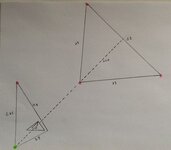
Here's an example of how cemeteries were used where I am to show a point of importance and then confirm it.

cem t.jpg

The pink dots are cemeteries and the green dot is a heart shaped pond. The numbers are miles and, as you can see, not to scale. The two small triangles, inside the right angle of the SW triangle, are cache related with many carvings and an open hole just outside the right angle of the smallest triangle. The dotted line starts at the midpoint between the two NE cemeteries, goes through the third cemetery of that triangle and straight to the heart pond. Two of the cemeteries on the big triangle had the same name and one of them has only one grave.
 

kanabite

Hero Member
May 27, 2006
549
368
southern utah
Detector(s) used
wander aimlessly in circles with camera in hand
Primary Interest:
All Treasure Hunting
Oh there is a much deeper meaning I think,
To that number I'm just too tired or lazy to find a link! Lol
 

Last edited:

Rebel - KGC

Gold Member
Jun 15, 2007
21,680
14,740
Reverse "74" to "47"... YORK RITE of Freemasonry includes Degrees 4-7... ROYAL ARCH or HOLY ROYAL ARCH; take it from there...
 

kanabite

Hero Member
May 27, 2006
549
368
southern utah
Detector(s) used
wander aimlessly in circles with camera in hand
Primary Interest:
All Treasure Hunting
Hi m dog , finding you a 74 link on the net that does not have all the weirdness along with it is proving to be somewhat difficult. Lol I guess I'll just put them up , then maybe you might consider Steve's comments about the new testament and the old solar religions .somewhere in the mix perhaps a guy could find a starting point .very hard to sift though all this stuff ,but the answers are out there some where.


"Seven Seals Mystery"


Jesus8880: The Sacred Geometry Mysteries of Christianity


English Gematria - The KEY & The LOCK - Esoteric Online


I still have not found what I'm looking for BTW . so many times the characters name change in our history but their stories started ? ? ? ?
 

OP
OP
M

mdog

Bronze Member
Mar 22, 2011
2,366
4,419
Reverse "74" to "47"... YORK RITE of Freemasonry includes Degrees 4-7... ROYAL ARCH or HOLY ROYAL ARCH; take it from there...

Thanks, Rebel. A little bit at a time, I'm learning about Freemasonry. It seems real complicated to me, but I'll keep reading.
 

Top Member Reactions

Users who are viewing this thread

Top